File list
This special page shows all uploaded files.
| Date | Name | Thumbnail | Size | User | Description | Versions |
|---|---|---|---|---|---|---|
| 16:31, 29 April 2024 | AirCom-BasesUS-AirMethods.png (file) |  |
98 KB | Starcom21 | AirCom US Bases Air Methods | 1 |
| 13:58, 16 March 2024 | Eight mile.png (file) | 12 KB | Drbeede | 1 | ||
| 16:19, 5 February 2024 | Portlandops2-qr.png (file) |  |
579 bytes | A417 | QR code with embedded link to FD Ops 2feed on zello.com | 1 |
| 16:07, 5 February 2024 | Portlandme-fd-dispatch-qr.png (file) |  |
490 bytes | A417 | QR code with embedded link to FD dispatch feed on zello.com | 1 |
| 17:13, 19 January 2024 | WCDPS.png (file) |  |
299 KB | Seagravebuff60 | WCPD Patch | 1 |
| 10:22, 17 January 2024 | White Plains Police badge.png.89c560bc1b3c75e40d0506ad4e084e71 1 .png (file) | 113 KB | Seagravebuff60 | 1 | ||
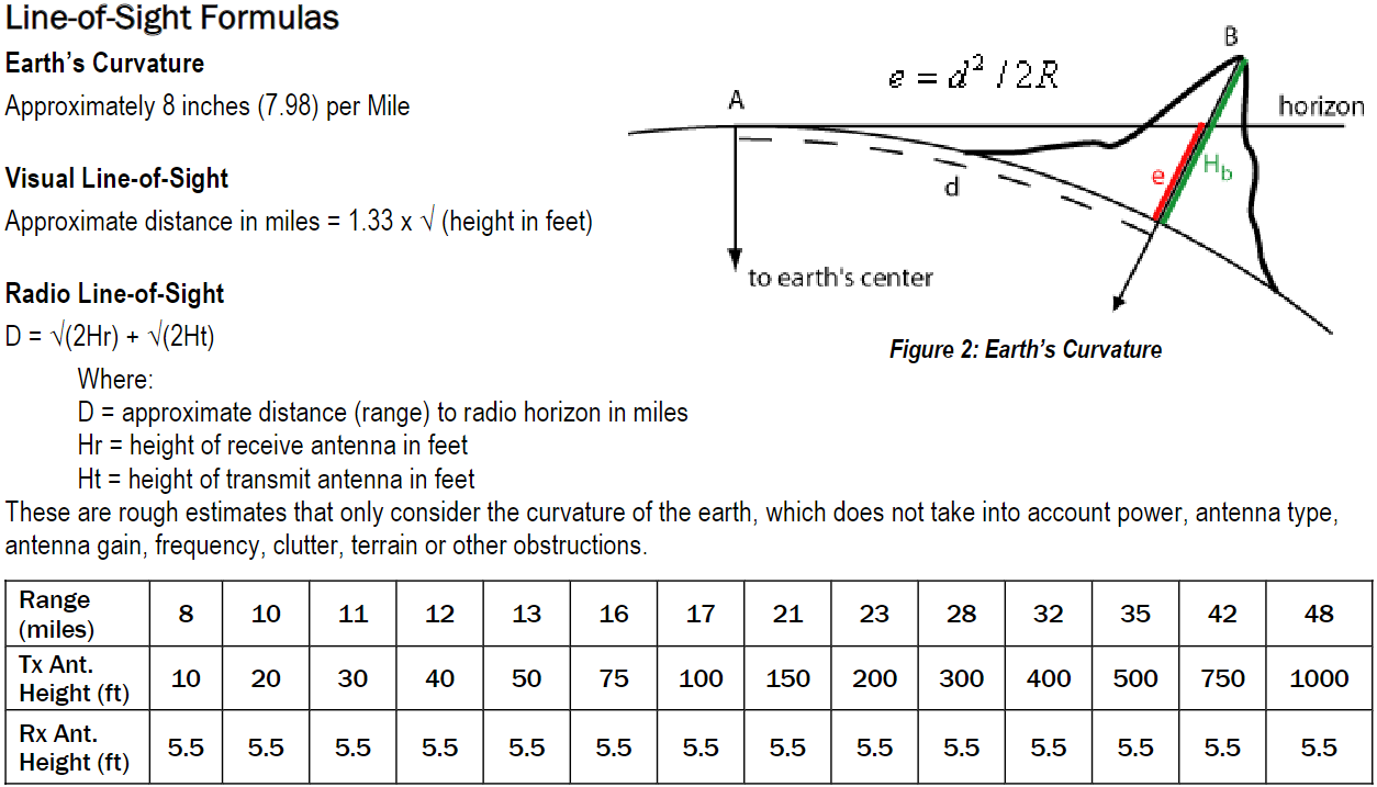
| 20:31, 13 January 2024 | Line-of-site-formulas.png (file) |  |
108 KB | Starcom21 | Line-of-Sight Formulas Earth’s Curvature Approximately 8 inches (7.98) per Mile Visual Line-of-Sight Approximate distance in miles = 1.33 x √ (height in feet) Radio Line-of-Sight D = √(2Hr) + √(2Ht) Where: D = approximate distance (range) to radio horizon in miles Hr = height of receive antenna in feet Ht = height of transmit antenna in feet These are rough estimates that only consider the curvature of the earth, which does not take into account power, antenna type, antenna gain, frequency, c... | 1 |
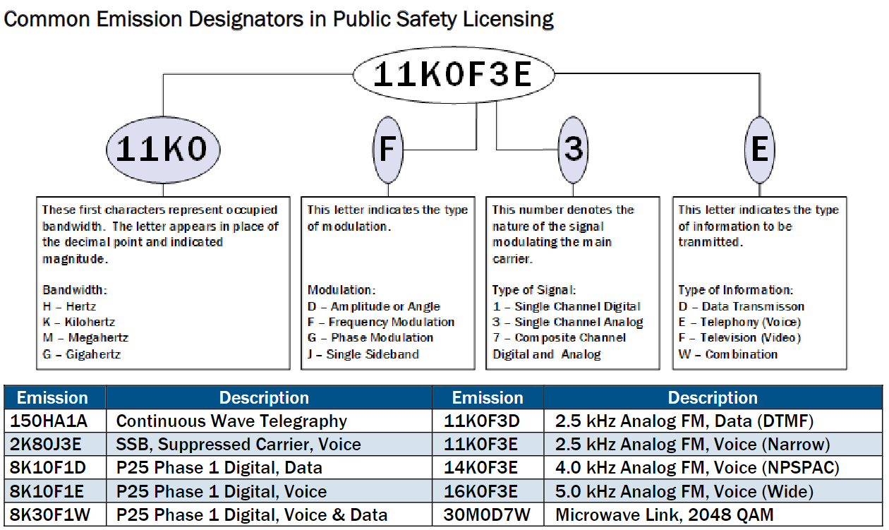
| 19:42, 13 January 2024 | Common Emission Designators.png (file) |  |
126 KB | Starcom21 | Common Emission Designators in Public Safety Licensing Emission Description Emission Description 150HA1A Continuous Wave Telegraphy 11K0F3D 2.5 kHz Analog FM, Data (DTMF) 2K80J3E SSB, Suppressed Carrier, Voice 11K0F3E 2.5 kHz Analog FM, Voice (Narrow) 8K10F1D P25 Phase 1 Digital, Data 14K0F3E 4.0 kHz Analog FM, Voice (NPSPAC) 8K10F1E P25 Phase 1 Digital, Voice 16K0F3E 5.0 kHz Analog FM, Voice (Wide) 8K30F1W P25 Phase 1 Digital, Voice & Data 30M0D7W Microwave Link, 2048 QAM | 1 |
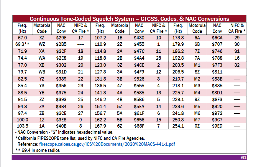
| 19:20, 13 January 2024 | CTCSS-NAC-codes.png (file) |  |
76 KB | Starcom21 | Continuous Tone-Coded Squelch System – CTCSS, Codes, & NAC Conversions Freq. (Hz) Motorola Code NAC Conv NIFC & CA Fire * Freq. (Hz) Motorola Code NAC Conv NIFC & CA Fire * Freq. (Hz) Motorola Code NAC Conv NIFC & CA Fire * 67.0 XZ $29E 17 107.2 1B $430 10 173.8 6A $6CA 29 69.3** WZ $2B5 ------ 110.9 2Z $455 1 179.9 6B $707 30 71.9 XA $2CF 18 114.8 2A $47C 11 186.2 7Z $746 31 74.4 WA $2E8 19 118.8 2B $4A4 28 192.8 7A $788 16 77.0 XB $302 20 123.0 3Z $4CE 2 203.5 M1 $7F3 32 79.7 WB $31D 21 127... | 1 |
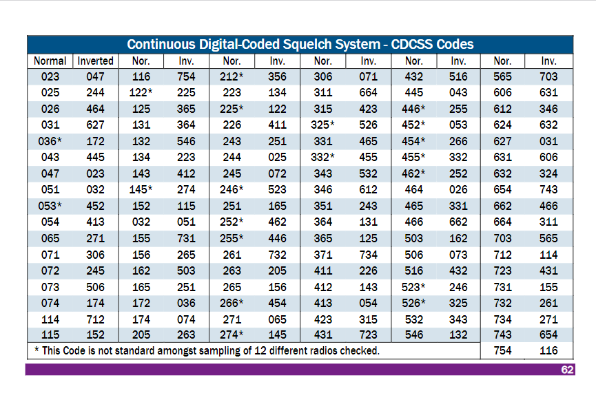
| 19:18, 13 January 2024 | CDCSS-tones.png (file) |  |
68 KB | Starcom21 | Continuous Tone-Coded Squelch System – CTCSS, Codes, & NAC Conversions Freq. (Hz) Motorola Code NAC Conv NIFC & CA Fire * Freq. (Hz) Motorola Code NAC Conv NIFC & CA Fire * Freq. (Hz) Motorola Code NAC Conv NIFC & CA Fire * 67.0 XZ $29E 17 107.2 1B $430 10 173.8 6A $6CA 29 69.3** WZ $2B5 ------ 110.9 2Z $455 1 179.9 6B $707 30 71.9 XA $2CF 18 114.8 2A $47C 11 186.2 7Z $746 31 74.4 WA $2E8 19 118.8 2B $4A4 28 192.8 7A $788 16 77.0 XB $302 20 123.0 3Z $4CE 2 203.5 M1 $7F3 32 79.7 WB $31D 21 127... | 1 |
| 14:03, 13 January 2024 | ADEM Emergency Management Area Map.png (file) |  |
147 KB | Starcom21 | Arkansas ADEM Emergency Management Area Map 2021 | 1 |
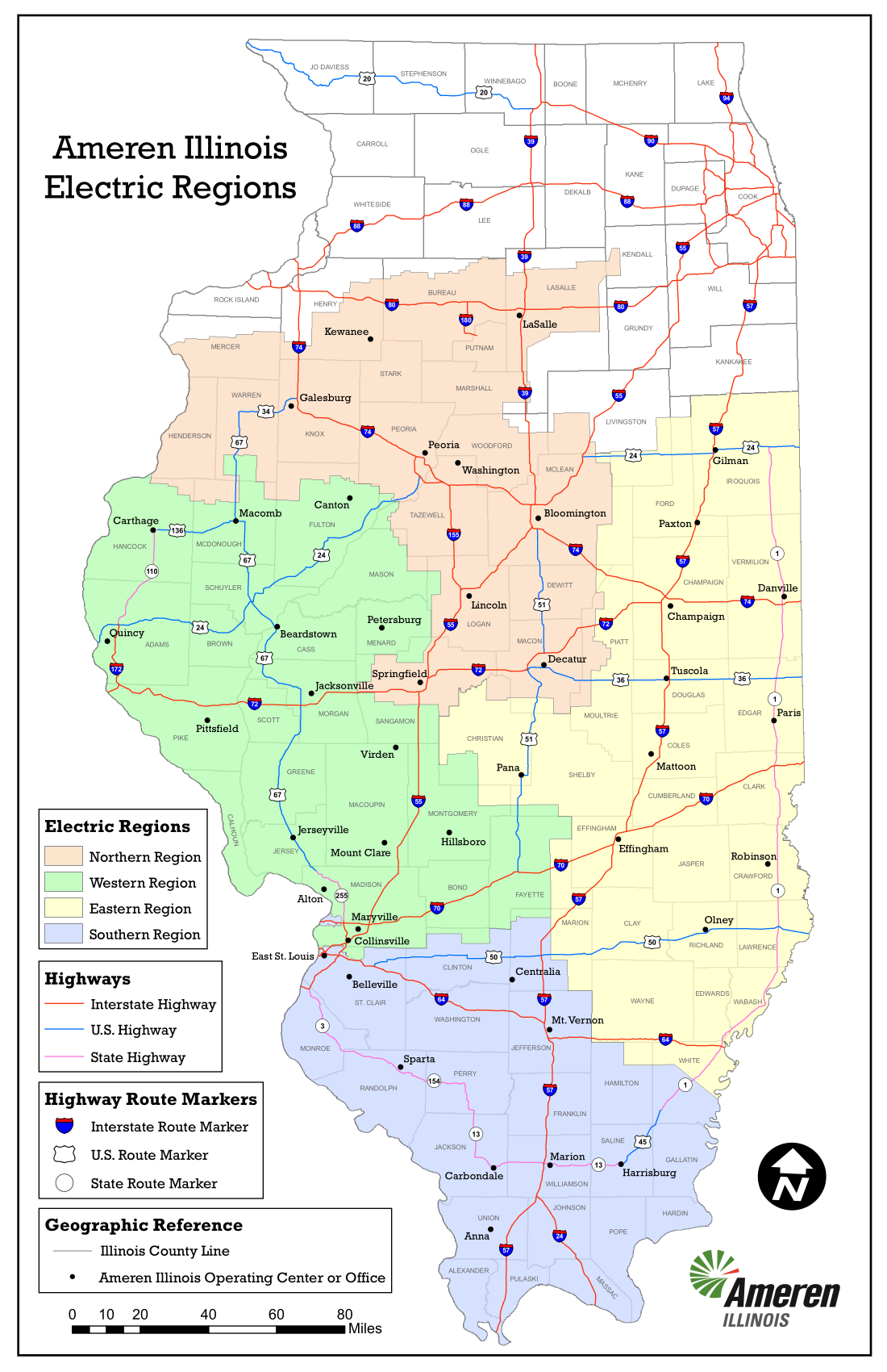
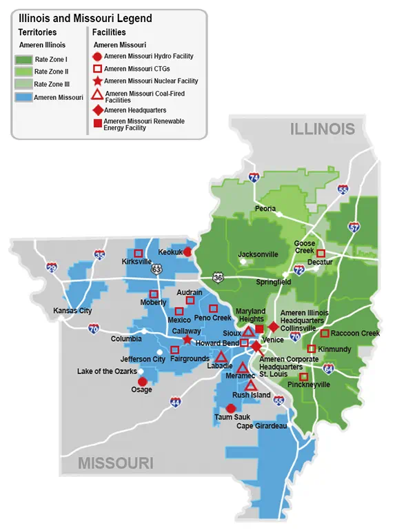
| 09:56, 11 January 2024 | AmerenIllinois-2023-service-territory-map-electric.png (file) |  |
463 KB | Starcom21 | Ameren Illinois 2023 service territory map electric | 1 |
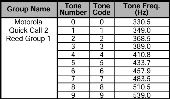
| 00:26, 2 January 2024 | Moto-QCII-Group1.png (file) |  |
53 KB | Rneals | 1 | |
| 18:36, 26 December 2023 | HDN CT.png (file) |  |
17 KB | Seagravebuff60 | 2 | |
| 18:36, 26 December 2023 | Marcus Com.png (file) |  |
4 KB | Seagravebuff60 | 2 | |
| 17:35, 26 December 2023 | A1logo.png (file) |  |
67 KB | Seagravebuff60 | 2 | |
| 09:01, 28 November 2023 | Triangle-logo-trans orig.png (file) | 7 KB | Seagravebuff60 | 3 | ||
| 12:10, 25 November 2023 | Goosetown Communications.png (file) |  |
15 KB | Seagravebuff60 | Goosetown Communications Logo | 1 |
| 16:14, 17 November 2023 | 1677775644677.png (file) | 181 KB | Michaelbrown2018 | 1 | ||
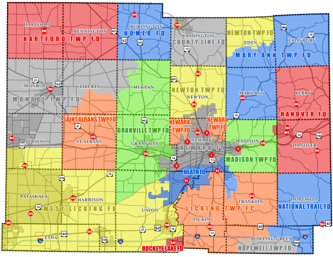
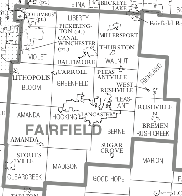
| 14:39, 8 November 2023 | LickingCountyFire.png (file) |  |
494 KB | Andrewtv08 | Small city annexations. Anticipating forming of County Line Fire District from former Utica Fire Department and Utica Emergency Squad beginning Jan 1, 2024. | 2 |
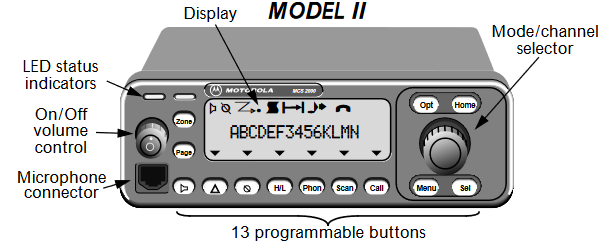
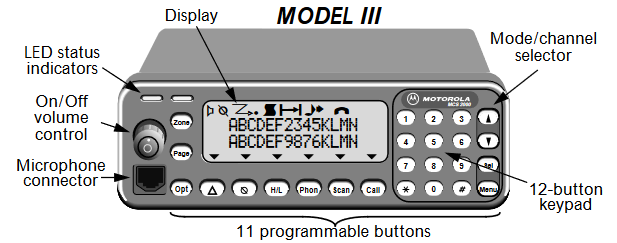
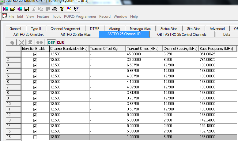
| 10:22, 5 November 2023 | Mcs2kmod2.png (file) |  |
36 KB | A417 | errant black line removed | 2 |
| 10:18, 5 November 2023 | Mcs2kmod3.png (file) |  |
32 KB | A417 | 1 | |
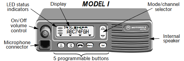
| 10:17, 5 November 2023 | Mcs2kmod1.png (file) |  |
30 KB | A417 | 1 | |
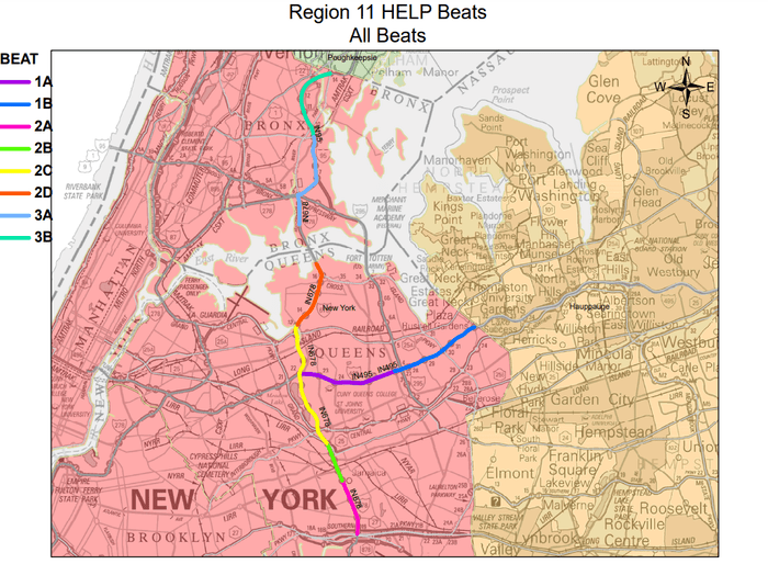
| 13:17, 23 October 2023 | R11 HELP.png (file) |  |
144 KB | Seagravebuff60 | NYSDOT HELP R11 Sector Map | 1 |
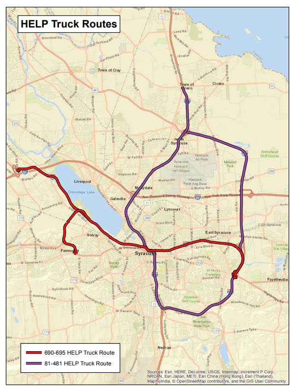
| 13:14, 23 October 2023 | R3 Help.png (file) |  |
733 KB | Seagravebuff60 | NYSDOT HELP R3 Trucks Sector Map | 1 |
| 12:26, 23 October 2023 | R11 Help.png (file) |  |
185 KB | Seagravebuff60 | NYSDOT R11 Help Sector Map | 1 |
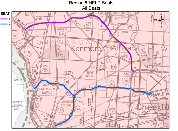
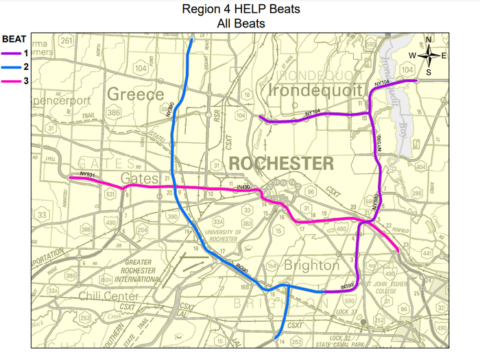
| 12:21, 23 October 2023 | R4 HELP.png (file) |  |
159 KB | Seagravebuff60 | 2 | |
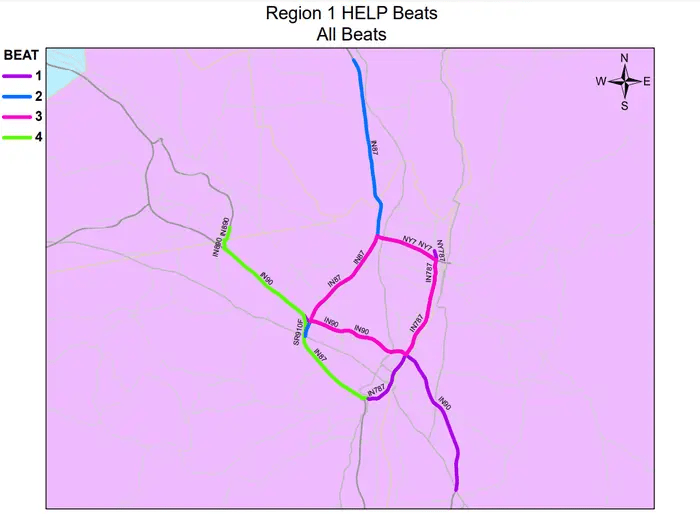
| 11:47, 23 October 2023 | 2023-10-23 12 37 44-HELP Map.mxd 700x514.png (file) |  |
94 KB | Seagravebuff60 | NYS DOT R1 Sector Map NEW | 1 |
| 11:19, 23 October 2023 | Help2.png (file) | 70 KB | Seagravebuff60 | NYSDOT HElP Trucks Logo | 1 | |
| 15:47, 17 October 2023 | Hazelwood-business-park-layout-with-idi-warehouse.png (file) |  |
1.19 MB | Starcom21 | Hazelwood-business-park-layout-with-idi-warehouse. | 1 |
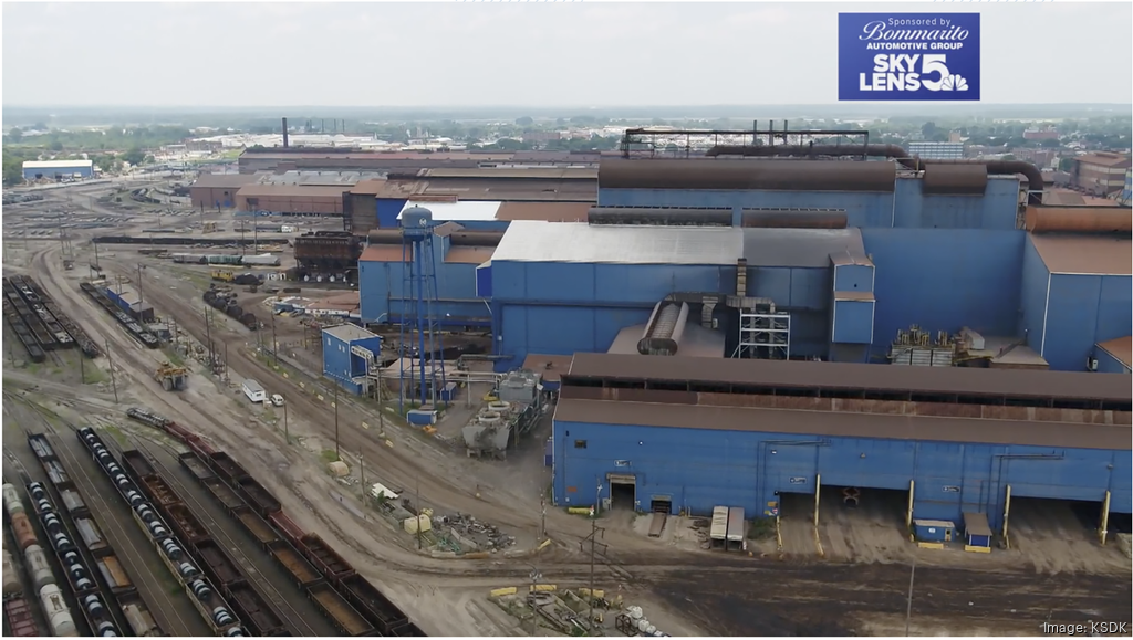
| 12:35, 3 October 2023 | Us-steel-granite-city-works-aerial-100223-ksdk.png (file) |  |
1.16 MB | Starcom21 | US Steel Granite City 2023 | 1 |
| 08:05, 19 September 2023 | Moswin sm.png (file) |  |
13 KB | Starcom21 | MOSWIN logo | 1 |
| 13:09, 27 August 2023 | Iemaohs.png (file) | 370 KB | Starcom21 | Illinois Emergency Management Agency and Office of Homeland Security logo | 1 | |
| 17:00, 25 August 2023 | Washu-297e3c194f501001b82869ee77820000.png (file) |  |
14 KB | Starcom21 | wash u logo st louis mo | 1 |
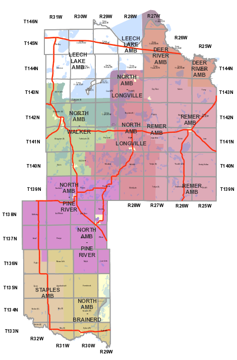
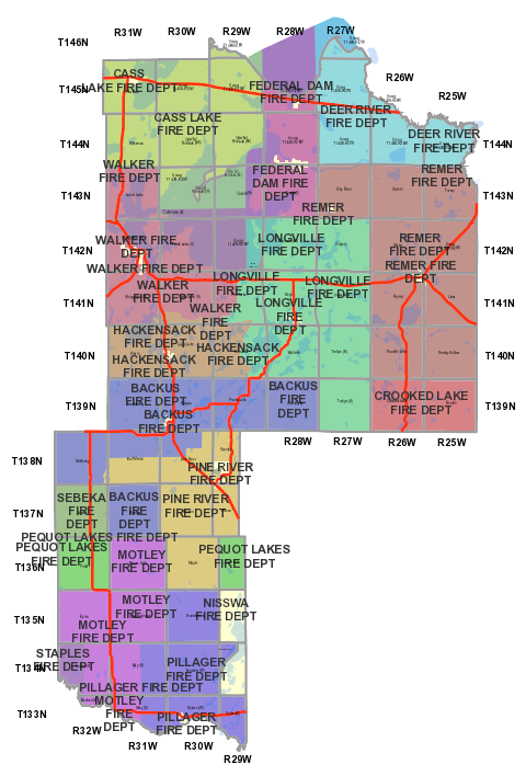
| 14:54, 24 August 2023 | Cass Co MN EMS Map.png (file) |  |
123 KB | Mmtstc | 2 | |
| 14:54, 24 August 2023 | Cass Co MN Fire Map.png (file) |  |
161 KB | Mmtstc | 2 | |
| 13:01, 8 August 2023 | ISP SOG MapPNG.png (file) |  |
935 KB | Starcom21 | Illinois State Police Strategic Operations Command 2023 | 1 |
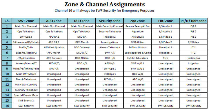
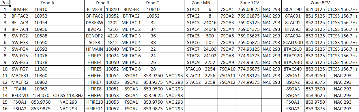
| 13:36, 4 August 2023 | Swf zones and channels.png (file) |  |
129 KB | Statcoaster | 1 | |
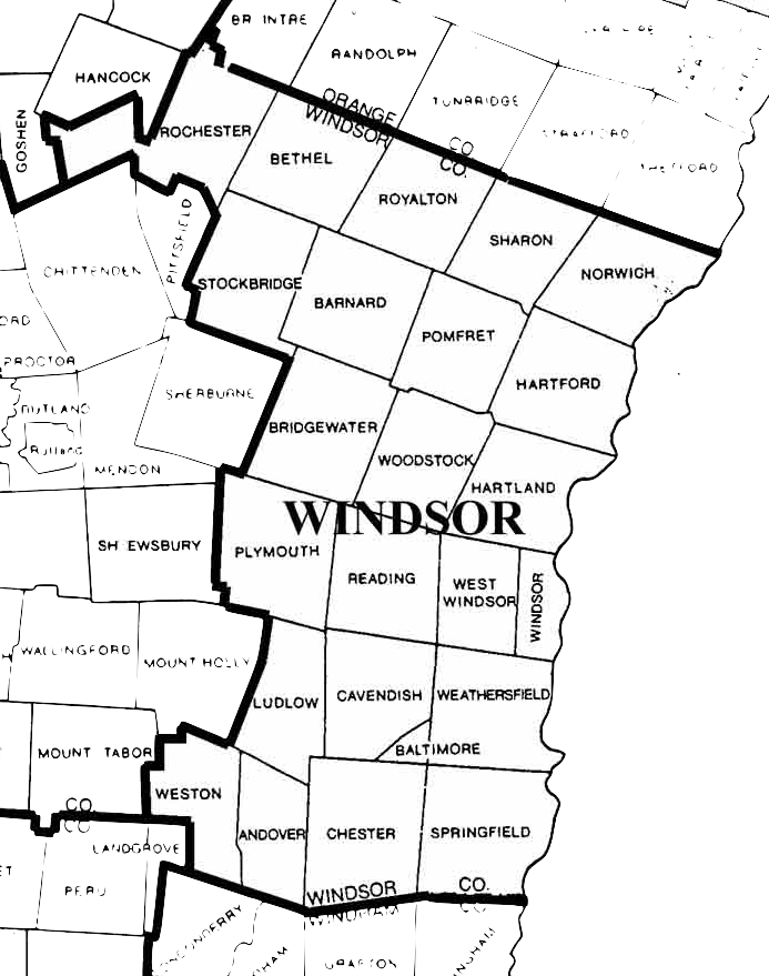
| 16:30, 21 July 2023 | Windsor County VT Map.png (file) |  |
272 KB | Battalion3leb | 1 | |
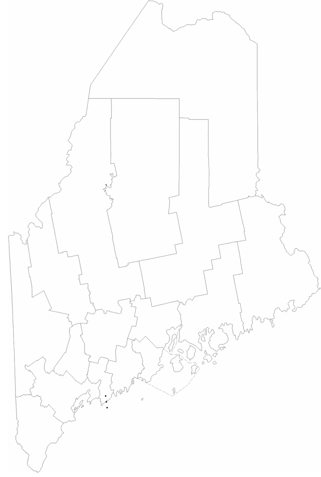
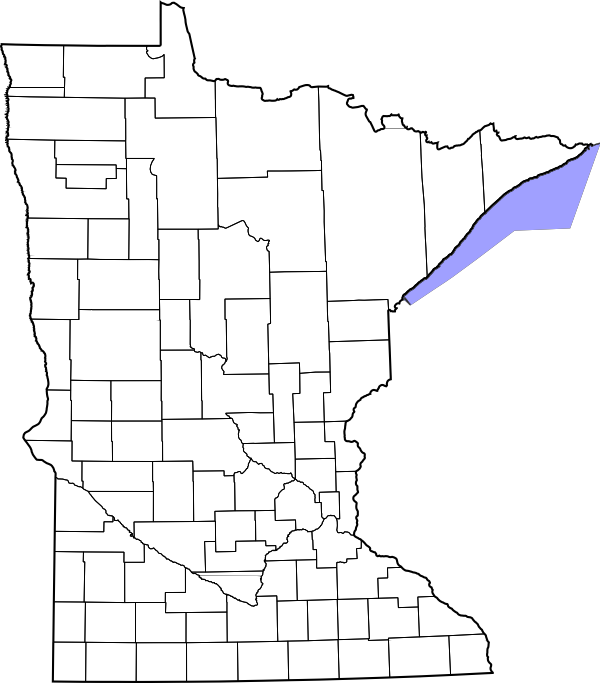
| 07:07, 19 July 2023 | Maine-counties.png (file) |  |
87 KB | A417 | 2 | |
| 13:17, 29 March 2023 | PeoriaStarkCountyJointETSBlogo.png (file) | 96 KB | Starcom21 | Peoria Stark County Joint ETSB logo | 1 | |
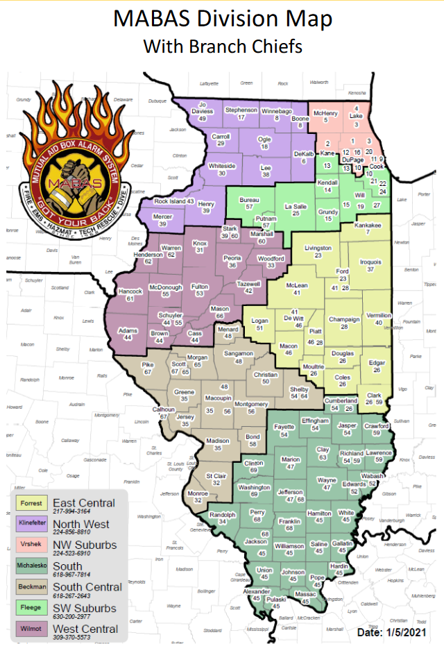
| 19:51, 20 March 2023 | MABAS2021.png (file) |  |
468 KB | Starcom21 | MABAS IL Fire Division Map 2021 by county | 1 |
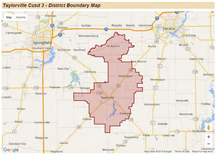
| 10:24, 16 March 2023 | TaylorvilleCUSD3map.png (file) |  |
490 KB | Starcom21 | Taylorville IL School District #3 Boundary Map | 1 |
| 06:15, 27 January 2023 | ISP-Troop3.png (file) |  |
19 KB | Starcom21 | Illinois State Police Troop 3 Metro Chicago 2023 | 1 |
| 11:53, 3 January 2023 | ISP Troop Map.png (file) |  |
1.53 MB | Spitfire8520 | Higher resolution image. | 2 |
| 16:49, 18 December 2022 | Ameren.png (file) |  |
266 KB | Starcom21 | 1 | |
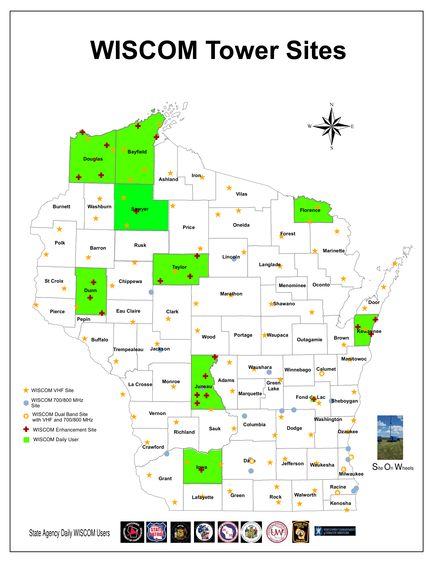
| 00:06, 18 November 2022 | WISCOM-2020.png (file) |  |
249 KB | DVINTHEHOUSEMAN | Latest WISCOM map | 1 |
| 14:03, 8 September 2022 | Firetg.png (file) |  |
113 KB | Kd7jfv | 1 | |
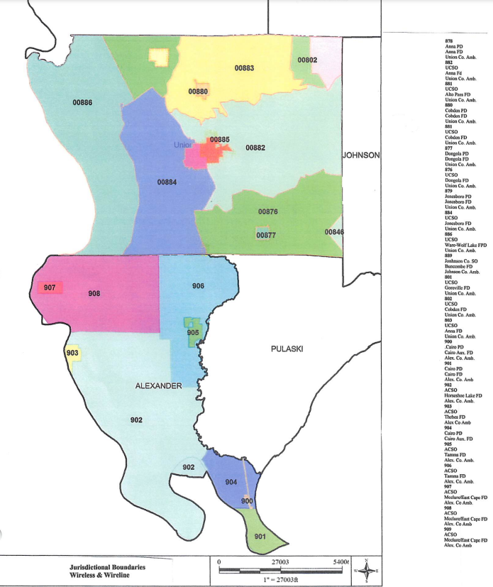
| 11:50, 1 August 2022 | Union.pdf 202281162839.png (file) |  |
420 KB | Starcom21 | Union Pulaski Alexander County 911 Map | 2 |
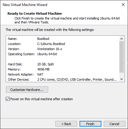
| 17:02, 24 July 2022 | Create VM Finish.png (file) |  |
13 KB | CanesFan95 | 1 | |
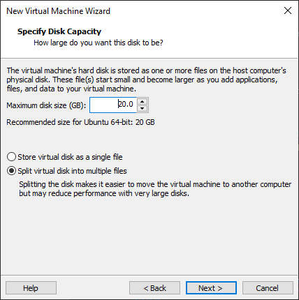
| 17:01, 24 July 2022 | VM Disk Size.png (file) |  |
13 KB | CanesFan95 | 1 | |
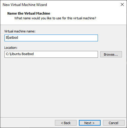
| 16:58, 24 July 2022 | Name Virtual Machine Boatbod.png (file) |  |
7 KB | CanesFan95 | 1 | |
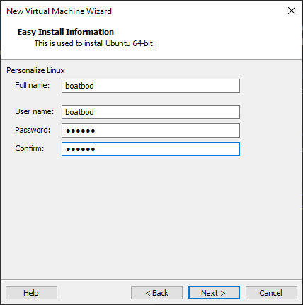
| 16:50, 24 July 2022 | Enter Password.png (file) |  |
7 KB | CanesFan95 | 1 | |
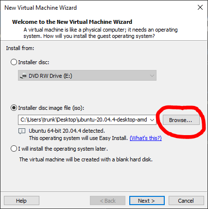
| 16:48, 24 July 2022 | Select Ubuntu .iso File.png (file) |  |
16 KB | CanesFan95 | 1 | |
| 16:45, 24 July 2022 | VMWare Green + Sign.png (file) |  |
6 KB | CanesFan95 | 1 | |
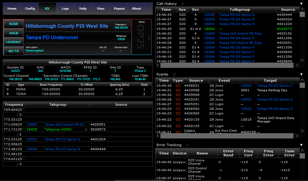
| 16:41, 24 July 2022 | OP25 Osmocom Screenshot.png (file) |  |
73 KB | CanesFan95 | 1 | |
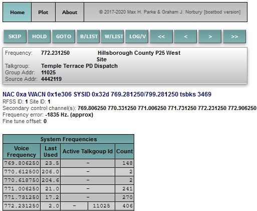
| 16:33, 24 July 2022 | OP25 Boatbod Screenshot.png (file) |  |
23 KB | CanesFan95 | 1 | |
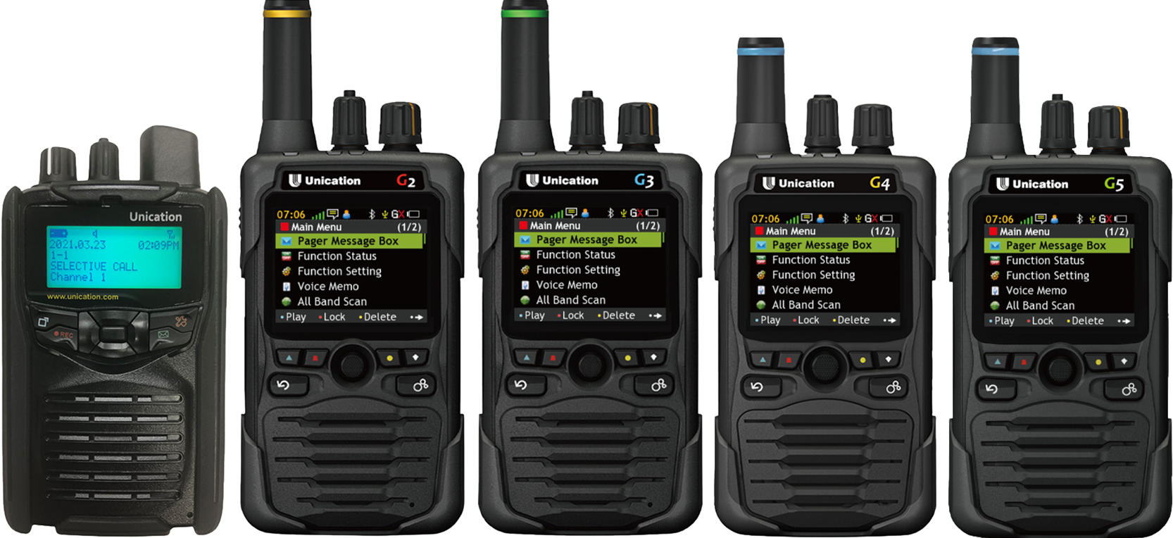
| 18:24, 5 June 2022 | GSeries Family.png (file) |  |
1.28 MB | Jabbeaux | 1 | |
| 18:02, 5 June 2022 | Unication G5.png (file) |  |
253 KB | Jabbeaux | fix sizing, background, screen | 2 |
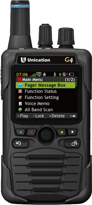
| 18:02, 5 June 2022 | Unication G4.png (file) |  |
200 KB | Jabbeaux | 2 | |
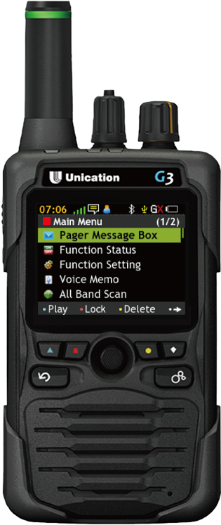
| 18:01, 5 June 2022 | Unication G3.png (file) |  |
271 KB | Jabbeaux | fix sizing, background, screen | 2 |
| 18:01, 5 June 2022 | Unication G2.png (file) |  |
271 KB | Jabbeaux | fix sizing, background, screen | 2 |
| 18:01, 5 June 2022 | Unication G1.png (file) |  |
242 KB | Jabbeaux | fix sizing, background, screen | 2 |
| 00:56, 24 May 2022 | G5 diagram.png (file) |  |
909 KB | Jabbeaux | Cleaned up layout, fully customized the text descriptions, significant formatting and layout changes. | 2 |
| 18:06, 28 April 2022 | NAFD Area Served.png (file) |  |
1.33 MB | Avdrummerboy | 1 | |
| 07:40, 31 March 2022 | LZ.png (file) |  |
83 KB | Bryanthered | 1 | |
| 20:31, 27 March 2022 | N1SP.png (file) |  |
452 KB | VOXScanningYT | 1 | |
| 16:34, 26 February 2022 | Madison County Fire Districts 2022a.png (file) |  |
110 KB | Cann1995 | 1 | |
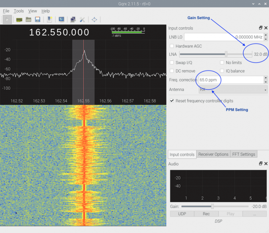
| 10:48, 18 April 2021 | RTL GQRX Gain PPM.png (file) |  |
892 KB | Blantonl | How to determine PPM and Gain for RTL Stick using GQRX | 1 |
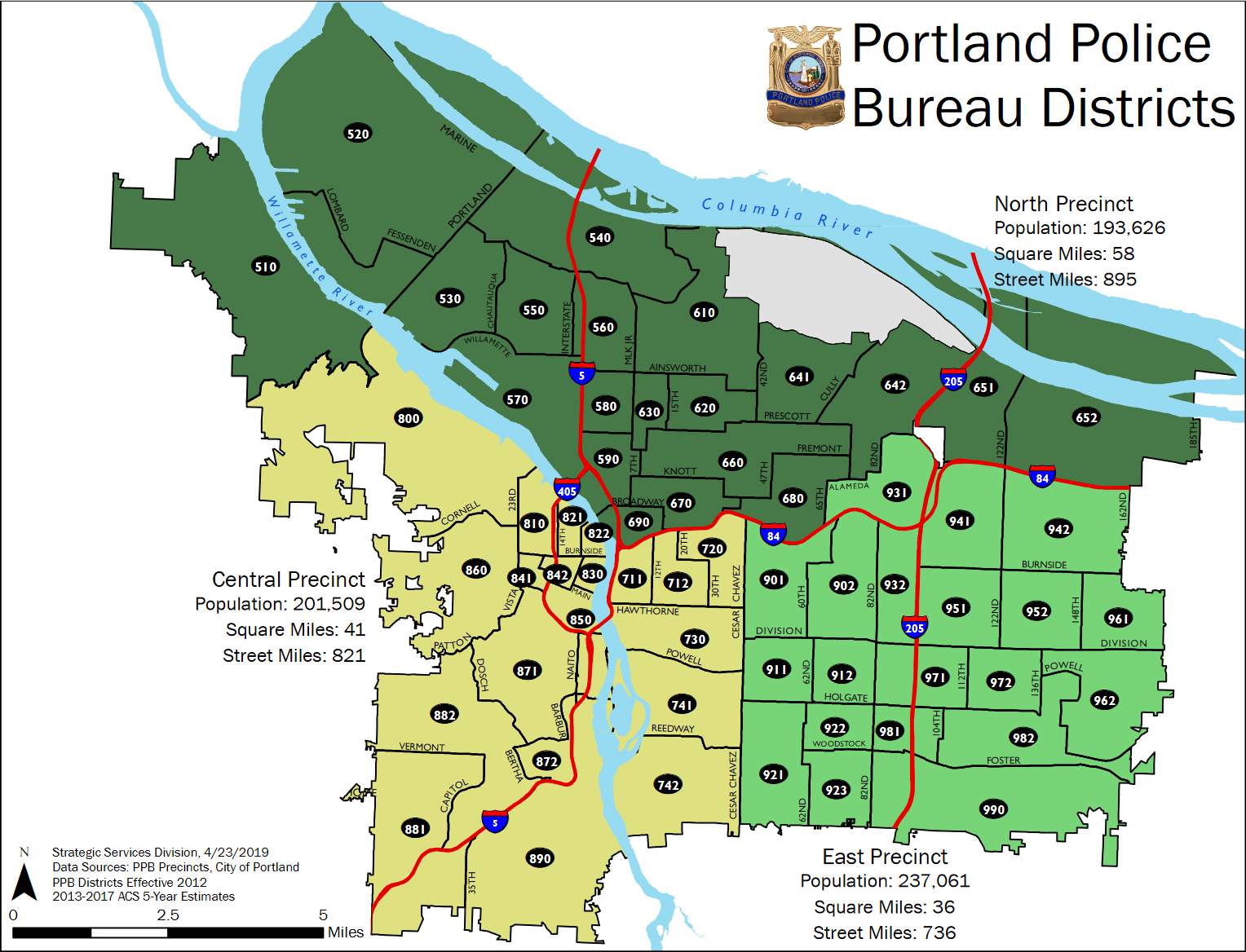
| 01:59, 9 March 2021 | PortlandORpoliceDistrictConsolidation.png (file) |  |
319 KB | V A R I A B L E | 1 | |
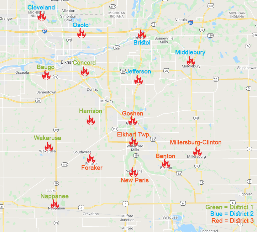
| 01:24, 21 November 2020 | Elkhart District Map.png (file) |  |
259 KB | FrostTheFox | Map of the Elkhart County fire districts. | 1 |
| 19:16, 9 November 2020 | DuPageSheriffPatrolBeats.png (file) |  |
710 KB | Starcom21 | DuPageSheriffPatrolBeats.png | 1 |
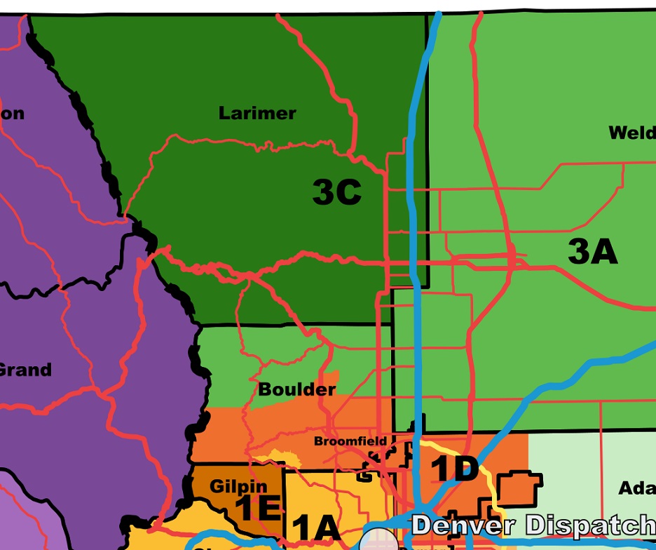
| 16:37, 18 October 2020 | Colorado-All-Hazards-Region-Map.png (file) |  |
411 KB | Rbuxton | 1 | |
| 16:15, 13 April 2020 | MPFD Fleetmap.png (file) |  |
20 KB | Fwfdengine2 | 1 | |
| 16:07, 13 April 2020 | Saint Louis Park Fleetmap.png (file) |  |
36 KB | Fwfdengine2 | 1 | |
| 16:03, 13 April 2020 | Richfield Fleetmap.png (file) |  |
40 KB | Fwfdengine2 | 1 | |
| 16:02, 13 April 2020 | Minnetonka Fleetmap.png (file) |  |
47 KB | Fwfdengine2 | 1 | |
| 16:00, 13 April 2020 | Hopkins Fire.png (file) |  |
29 KB | Fwfdengine2 | 1 | |
| 15:59, 13 April 2020 | Golden Valley Fleetmap.png (file) |  |
29 KB | Fwfdengine2 | 1 | |
| 15:58, 13 April 2020 | Excelsior Fleetmap.png (file) |  |
31 KB | Fwfdengine2 | 1 | |
| 15:56, 13 April 2020 | Edina Fleetmap.png (file) |  |
41 KB | Fwfdengine2 | 1 | |
| 15:41, 13 April 2020 | Eden Prairie Fleetmap.png (file) | 30 KB | Fwfdengine2 | 1 | ||
| 15:25, 13 April 2020 | Bloomington Fleetmap.png (file) |  |
64 KB | Fwfdengine2 | 1 | |
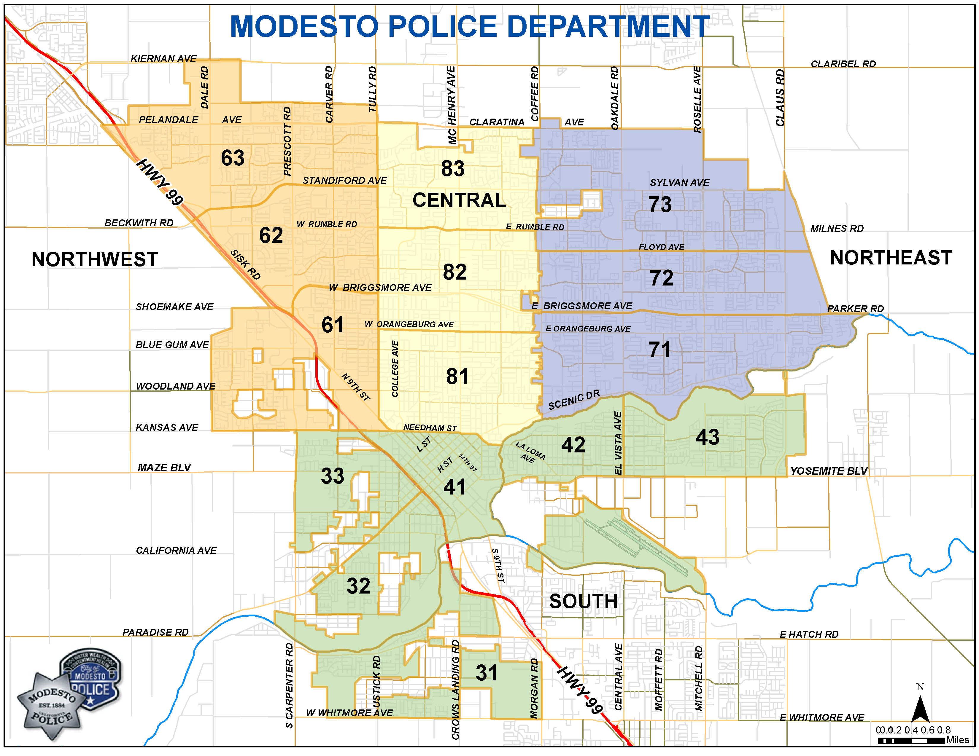
| 12:48, 21 March 2020 | Modesto Police Beat Map 2020.png (file) |  |
491 KB | 2k1typeSH | 1 | |
| 17:26, 16 March 2020 | NYSP.png (file) |  |
134 KB | Seagravebuff60 | 2 | |
| 17:22, 16 March 2020 | NYSP MAP.png (file) |  |
287 KB | Seagravebuff60 | 1 | |
| 17:12, 16 March 2020 | Download.png (file) |  |
20 KB | Seagravebuff60 | 1 | |
| 16:49, 16 March 2020 | Unnamed.png (file) |  |
18 KB | Seagravebuff60 | 1 | |
| 13:54, 12 March 2020 | Nsp map.png (file) | 261 KB | Orion ne | 1 | ||
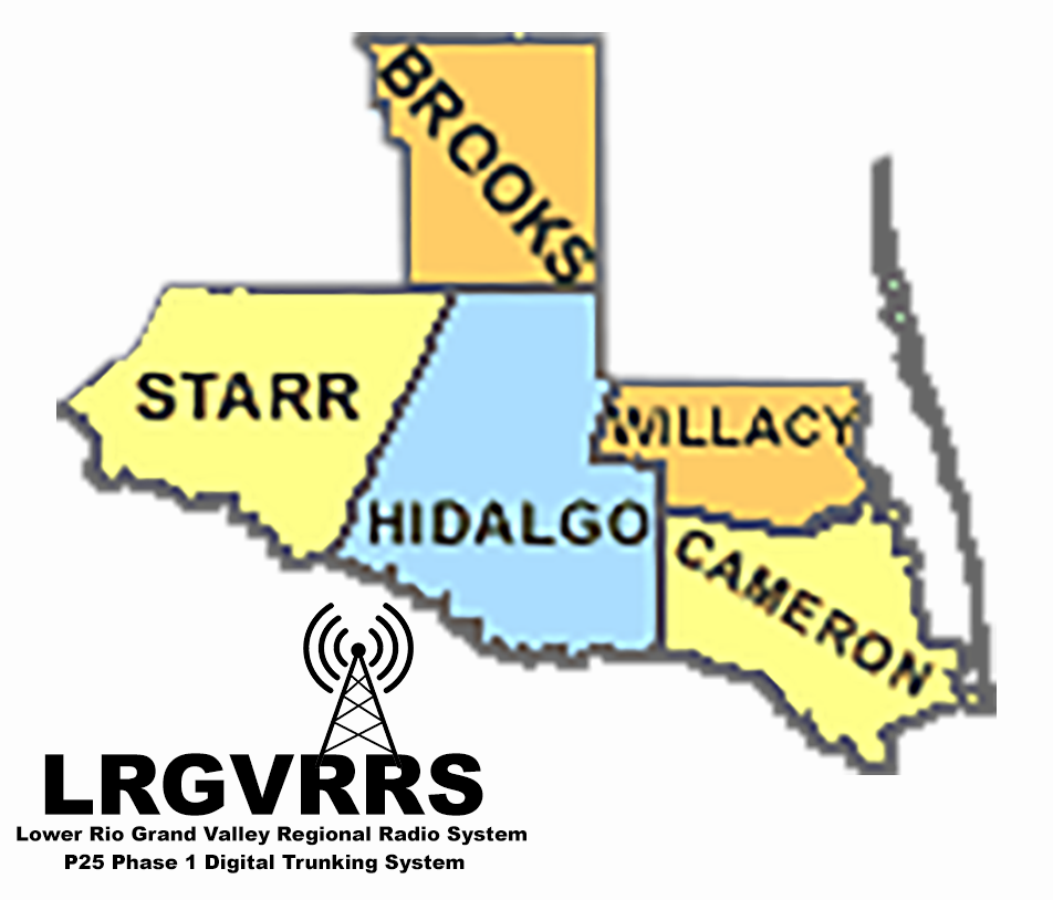
| 10:12, 17 December 2019 | LRGVRRS-county-map.png (file) |  |
313 KB | Jimbo 103 | 1 | |
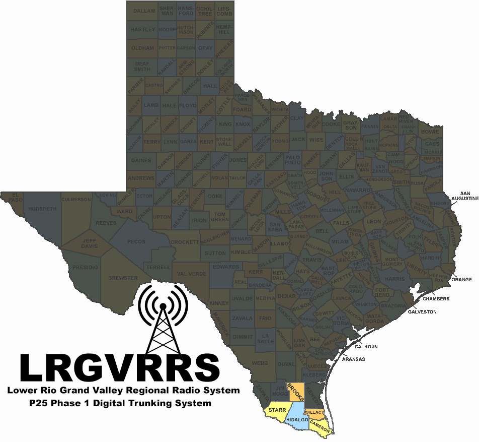
| 10:11, 17 December 2019 | LRGVRRS-map.png (file) |  |
192 KB | Jimbo 103 | 1 | |
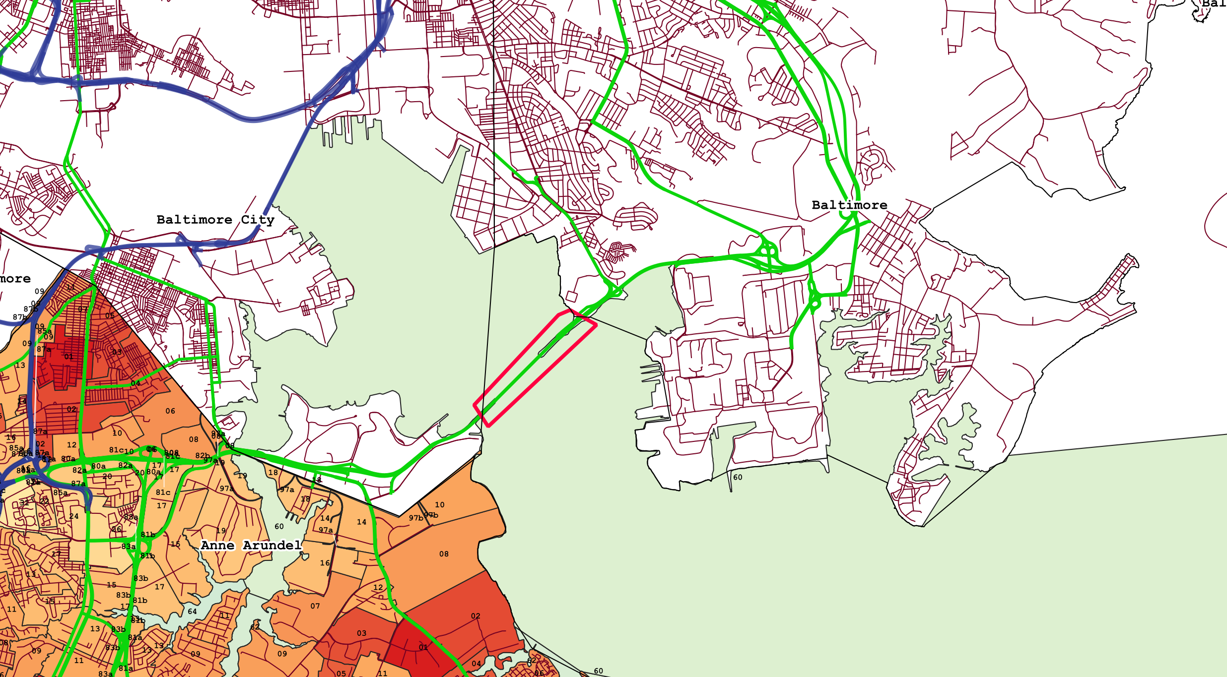
| 10:30, 13 December 2019 | Key Bridge.png (file) |  |
1.65 MB | Jpeterson24 | 1 | |
| 09:25, 13 December 2019 | SB I97 & EB RT3.png (file) |  |
703 KB | Jpeterson24 | 1 | |
| 20:19, 29 August 2019 | CSP Troops3.PNG (file) |  |
158 KB | Crazy88 | 2 | |
| 13:00, 13 May 2019 | Fairfield County Ohio Map.png (file) |  |
79 KB | Wa8pyr | 1 | |
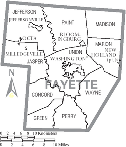
| 12:55, 13 May 2019 | Fayette County Ohio Map.png (file) |  |
58 KB | Wa8pyr | 1 | |
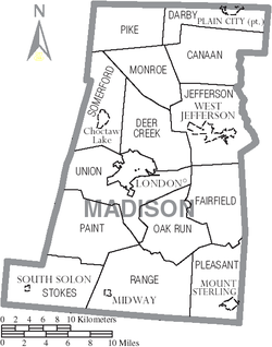
| 11:27, 13 May 2019 | Madison County Ohio Map.png (file) |  |
63 KB | Wa8pyr | 1 | |
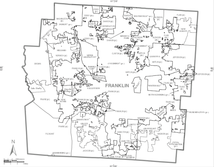
| 11:23, 13 May 2019 | Franklin County Ohio Map.png (file) |  |
211 KB | Wa8pyr | Map of Franklin County | 1 |
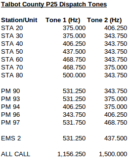
| 18:11, 12 May 2019 | Talbot P25 Tones.png (file) |  |
24 KB | Boatbod | 1 | |
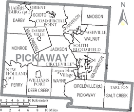
| 15:25, 12 May 2019 | Pickaway County Ohio Map.png (file) |  |
73 KB | Wa8pyr | Pickaway County Ohio | 1 |
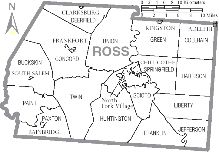
| 12:53, 9 May 2019 | Ross County Ohio.png (file) |  |
47 KB | Wa8pyr | Ross County map with townships | 1 |
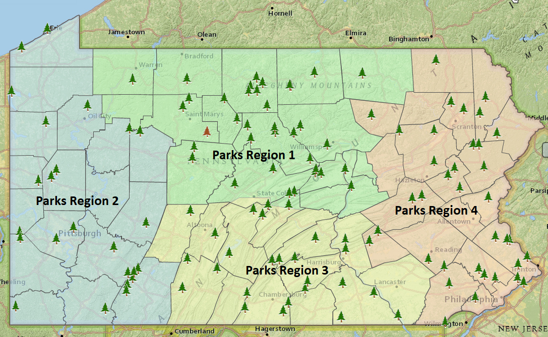
| 15:03, 25 February 2019 | Park Region Map.PNG (file) |  |
1.58 MB | HM1529 | 1 | |
| 14:45, 11 February 2019 | Radio IDs on the PA 700Mhz Air- ground systems 2.png (file) |  |
10 KB | KB3KBR | This is a screen shot of all heard RIDS on the 700Mhz Air-Ground syatem as recieved from the Venango site. | 1 |
| 14:38, 11 February 2019 | Radio IDs on the PA 700Mhz Air- ground systems 1.png (file) |  |
34 KB | KB3KBR | This is a screen shot of all heard RIDS on the 700Mhz Air-Ground syatem as recieved from the Venango site. | 1 |
| 10:00, 10 January 2019 | Web UNIDEN-SDS200-LoQTR LEFT-rt.png (file) |  |
926 KB | Phyberoptics | Uniden SDS200 | 1 |
| 22:48, 7 December 2018 | RS13 ChannelMap.png (file) |  |
19 KB | Gilligan | 1 | |
| 14:03, 6 June 2018 | ScanMacoupinCountyFBpageCover.png (file) |  |
273 KB | Starcom21 | 1 | |
| 23:40, 9 July 2017 | TrunkPlayer.png (file) |  |
81 KB | Northernsummit | 1 | |
| 03:07, 28 January 2017 | CSP Troops.PNG (file) |  |
1.77 MB | Spitfire8520 | Changed resolution for thumbnail rendering. | 4 |
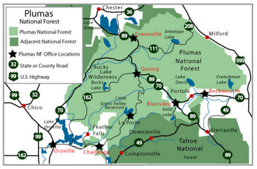
| 04:09, 7 June 2016 | R5 Plumas NF Mini Map 2016.PNG (file) |  |
668 KB | Exsmokey | Mini Map of the Plumas National Forest. | 1 |
| 17:22, 3 April 2016 | OSP Dispatcher Map.png (file) |  |
571 KB | Wa8pyr | 1 | |
| 20:30, 31 March 2016 | P25trunking1.png (file) |  |
49 KB | W9BU | 1 | |
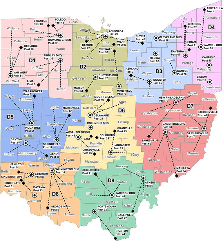
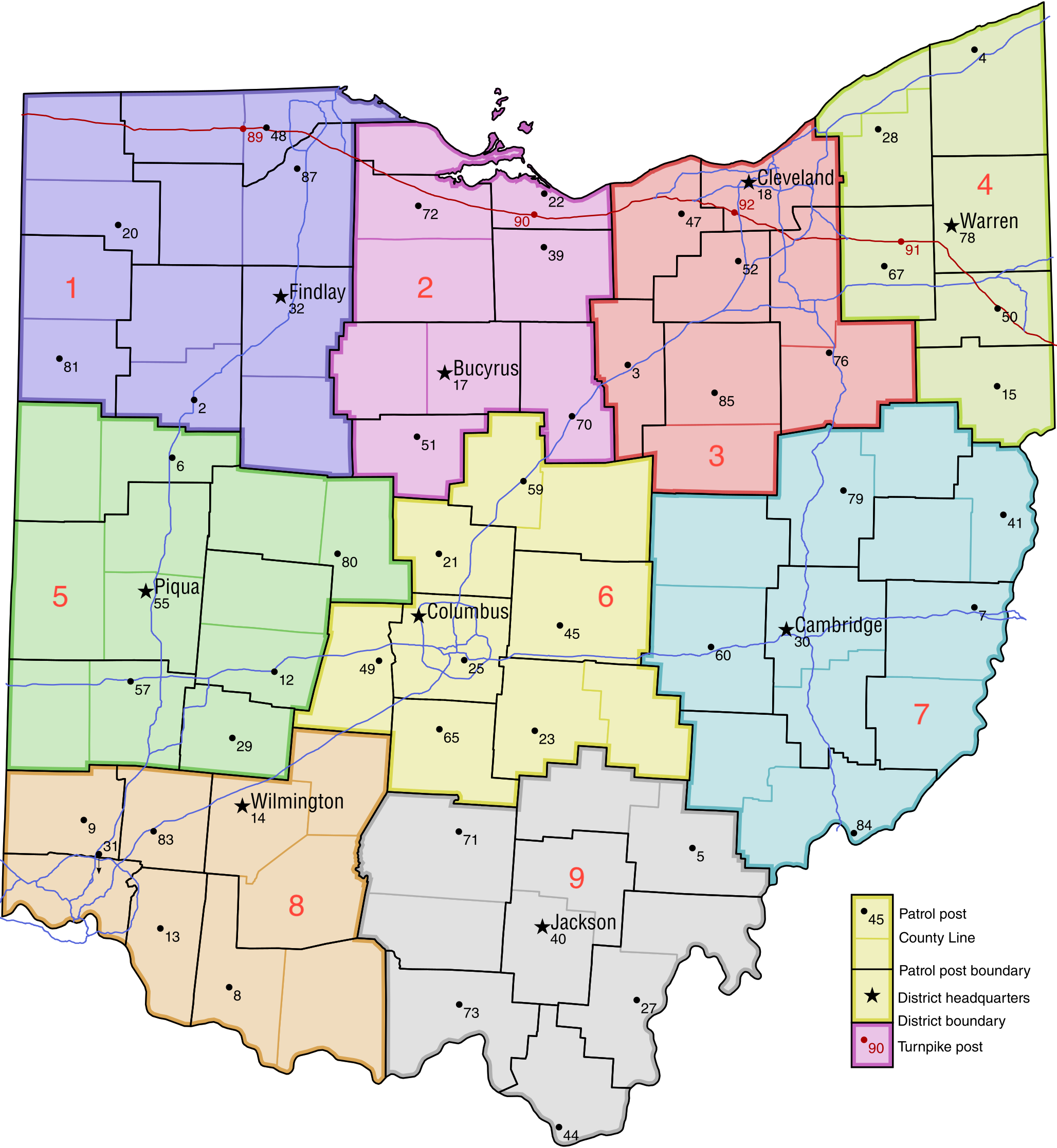
| 23:54, 24 January 2016 | Ohio Highway Patrol Map.png (file) |  |
749 KB | Ibagli | new districts | 17 |
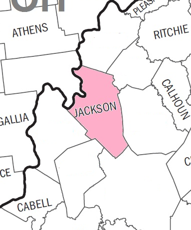
| 13:00, 18 July 2015 | JacksonCountyWV-Blank.png (file) | 123 KB | Andrewtv08 | Blank map for neighboring county links. | 1 | |
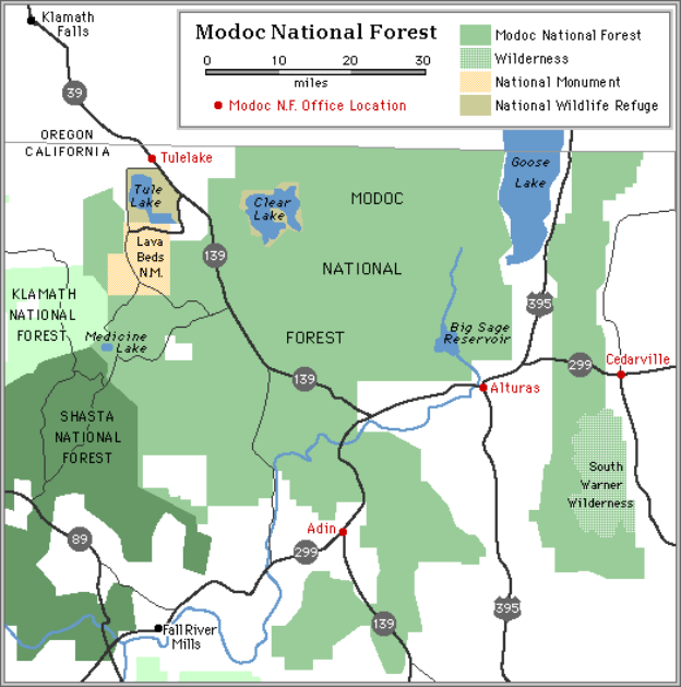
| 09:59, 24 March 2015 | USFS CA Modoc NF Small Map.png (file) |  |
122 KB | Exsmokey | Modoc NF Small Map. | 1 |
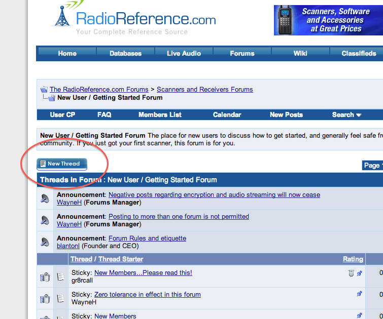
| 14:02, 24 February 2015 | NewThread.png (file) |  |
137 KB | Blantonl | 1 | |
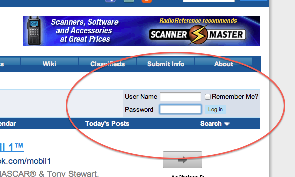
| 13:55, 24 February 2015 | Forums login.png (file) |  |
88 KB | Blantonl | 1 | |
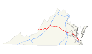
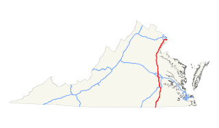
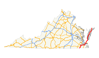
| 02:21, 24 February 2015 | TRVA Map I64 320px.png (file) |  |
18 KB | QDP2012 | Map of I-64 in Virginia License: http://en.wikipedia.org/wiki/File:I-64_%28VA%29_map.svg Creator: http://commons.wikimedia.org/wiki/User:25or6to4 Source: ImgFile=http://upload.wikimedia.org/wikipedia/commons/thumb/2/26/I-64_%28VA%29_map.svg/320px-I-64_ | 1 |
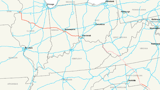
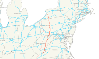
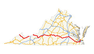
| 02:16, 24 February 2015 | TRVA Map I66 320px.png (file) |  |
43 KB | QDP2012 | Map of I-66 in Virginia License: http://en.wikipedia.org/wiki/File:Interstate_66_map.png Creator: http://en.wikipedia.org/wiki/User:Stratosphere Source: ImgFile=http://upload.wikimedia.org/wikipedia/commons/thumb/5/54/Interstate_66_map.png/320px-Inters | 1 |
| 02:11, 24 February 2015 | TRVA Map I74 320px.png (file) |  |
69 KB | QDP2012 | Map of I-74 in Virginia License: http://en.wikipedia.org/wiki/File:Interstate_74_map.png Creator: http://en.wikipedia.org/wiki/User:Stratosphere Source: ImgFile=http://upload.wikimedia.org/wikipedia/commons/thumb/1/1d/Interstate_74_map.png/320px-Inters | 1 |
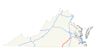
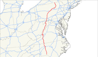
| 02:06, 24 February 2015 | TRVA Map I77 320px.png (file) |  |
18 KB | QDP2012 | Map of I-77 in Virginia License: http://en.wikipedia.org/wiki/File:I-77_%28VA%29_map.svg Creator: http://commons.wikimedia.org/wiki/User:25or6to4 Source: ImgFile=http://upload.wikimedia.org/wikipedia/commons/thumb/5/58/I-77_%28VA%29_map.svg/320px-I-77_ | 1 |
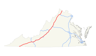
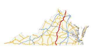
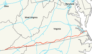
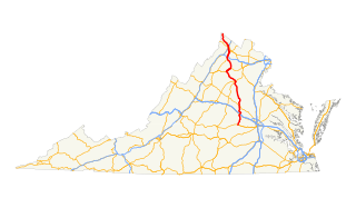
| 01:59, 24 February 2015 | TRVA Map I81 320px.png (file) |  |
19 KB | QDP2012 | Map of I-81 in Virginia License: http://en.wikipedia.org/wiki/File:I-81_%28VA%29_map.svg Creator: http://commons.wikimedia.org/wiki/User:25or6to4 Source: ImgFile=http://upload.wikimedia.org/wikipedia/commons/thumb/d/d4/I-81_%28VA%29_map.svg/320px-I-81_ | 1 |
| 01:49, 24 February 2015 | TRVA Map I85 320px.png (file) |  |
18 KB | QDP2012 | Map of I-95 in Virginia License: http://en.wikipedia.org/wiki/File:I-85_%28VA%29_map.svg Creator: http://commons.wikimedia.org/wiki/User:25or6to4 Source: ImgFile=http://upload.wikimedia.org/wikipedia/commons/thumb/b/b9/I-85_%28VA%29_map.svg/320px-I-85_ | 1 |
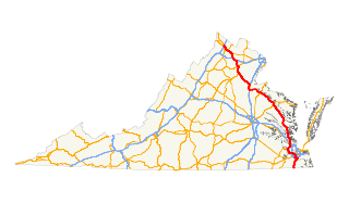
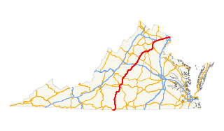
| 01:35, 24 February 2015 | TRVA Map I95 320px.png (file) |  |
18 KB | QDP2012 | Map of I-95 in Virginia License: http://en.wikipedia.org/wiki/File:I-95_%28VA%29_map.svg Creator: http://commons.wikimedia.org/wiki/User:25or6to4 Source: ImgFile=http://upload.wikimedia.org/wikipedia/commons/thumb/c/c3/I-95_%28VA%29_map.svg/320px-I-95_ | 1 |
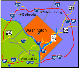
| 01:29, 24 February 2015 | TRVA Map I495 277px.png (file) |  |
48 KB | QDP2012 | Map of I-495 (Capital Beltway) in Virginia License: http://en.wikipedia.org/wiki/File:Capital_Beltway_Map_Color.svg Creator: http://commons.wikimedia.org/wiki/User:Squiggygfm Source: ImgFile=http://upload.wikimedia.org/wikipedia/commons/thumb/2/21/Capi | 1 |
| 01:16, 24 February 2015 | TRVA Map US01 320px.png (file) |  |
28 KB | QDP2012 | Map of US 1 in Virginia License: http://en.wikipedia.org/wiki/File:US_1_%28VA%29_map.svg Creator: http://commons.wikimedia.org/wiki/User:25or6to4 Source: ImgFile=http://upload.wikimedia.org/wikipedia/commons/thumb/b/be/US_1_%28VA%29_map.svg/320px-US_1_ | 1 |
| 01:09, 24 February 2015 | TRVA Map US11 320px.png (file) |  |
30 KB | QDP2012 | Map of US 11 in Virginia License: http://en.wikipedia.org/wiki/File:US_11_%28VA%29_map.svg Creator: http://commons.wikimedia.org/wiki/User:25or6to4 Source: ImgFile=http://upload.wikimedia.org/wikipedia/commons/thumb/3/3f/US_11_%28VA%29_map.svg/320px-US | 1 |
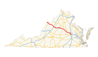
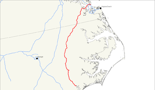
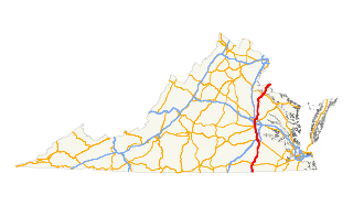
| 01:04, 24 February 2015 | TRVA Map US13 320px.png (file) |  |
28 KB | QDP2012 | Map of US 13 in Virginia License: http://en.wikipedia.org/wiki/File:US_13_%28VA%29_map.svg Creator: http://commons.wikimedia.org/wiki/User:25or6to4 Source: ImgFile=http://upload.wikimedia.org/wikipedia/commons/thumb/f/fa/US_13_%28VA%29_map.svg/320px-US | 1 |
| 00:56, 24 February 2015 | TRVA Map US15 320px.png (file) |  |
28 KB | QDP2012 | Map of US 15 in Virginia License: http://en.wikipedia.org/wiki/File:US_15_%28VA%29_map.svg Creator: http://commons.wikimedia.org/wiki/User:25or6to4 Source: ImgFile=http://upload.wikimedia.org/wikipedia/commons/thumb/e/e8/US_15_%28VA%29_map.svg/320px-US | 1 |
| 00:18, 24 February 2015 | TRVA Map US17 320px.png (file) |  |
28 KB | QDP2012 | Map of US 17 in Virginia License: http://en.wikipedia.org/wiki/File:US_17_%28VA%29_map.svg Creator: http://commons.wikimedia.org/wiki/User:25or6to4 Source: ImgFile=http://upload.wikimedia.org/wikipedia/commons/thumb/8/80/US_17_%28VA%29_map.svg/320px-US | 1 |
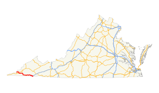
| 00:10, 24 February 2015 | TRVA Map US19 320px.png (file) |  |
28 KB | QDP2012 | Map of US 19 in Virginia License: http://en.wikipedia.org/wiki/File:US_19_%28VA%29_map.svg Creator: http://commons.wikimedia.org/wiki/User:25or6to4 Source: ImgFile=http://upload.wikimedia.org/wikipedia/commons/thumb/3/3c/US_19_%28VA%29_map.svg/320px-US | 1 |
| 00:03, 24 February 2015 | TRVA Map US21 320px.png (file) |  |
65 KB | QDP2012 | Map of US 21 in Virginia License: http://en.wikipedia.org/wiki/File:US_21_map.png Creator: http://en.wikipedia.org/wiki/User:Stratosphere Source: ImgFile=http://upload.wikimedia.org/wikipedia/commons/thumb/a/a0/US_21_map.png/320px-US_21_map.png | 1 |
| 23:57, 23 February 2015 | TRVA Map US23 320px.png (file) |  |
28 KB | QDP2012 | Map of US 23 in Virginia License: http://en.wikipedia.org/wiki/File:US_23_%28VA%29_map.svg Creator: http://commons.wikimedia.org/wiki/User:25or6to4 Source: ImgFile=http://upload.wikimedia.org/wikipedia/commons/thumb/8/8a/US_23_%28VA%29_map.svg/320px-US | 1 |
| 16:49, 23 February 2015 | TRVA Map US29 320px.png (file) |  |
28 KB | QDP2012 | Map of US 29 in Virginia License: http://en.wikipedia.org/wiki/File:US_29_%28VA%29_map.svg Creator: http://commons.wikimedia.org/wiki/User:25or6to4 Source: ImgFile=http://upload.wikimedia.org/wikipedia/commons/thumb/8/89/US_29_%28VA%29_map.svg/320px-US | 1 |
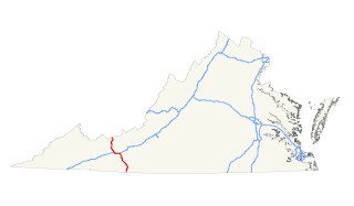
| 16:43, 23 February 2015 | TRVA Map US33 320px.png (file) |  |
28 KB | QDP2012 | Map of US 33 in Virginia License: http://en.wikipedia.org/wiki/File:US_33_%28VA%29_map.svg Creator: http://commons.wikimedia.org/wiki/User:25or6to4 Source: ImgFile=http://upload.wikimedia.org/wikipedia/commons/thumb/2/26/US_33_%28VA%29_map.svg/320px-US | 1 |
| 16:37, 23 February 2015 | TRVA Map US50 320px.png (file) |  |
30 KB | QDP2012 | Map of US 50 in Virginia License: http://en.wikipedia.org/wiki/File:US_50_%28VA%29_map.svg Creator: http://commons.wikimedia.org/wiki/User:25or6to4 Source: ImgFile=http://upload.wikimedia.org/wikipedia/commons/thumb/8/81/US_50_%28VA%29_map.svg/320px-US | 1 |
| 16:32, 23 February 2015 | TRVA Map US52 320px.png (file) |  |
28 KB | QDP2012 | Map of US 52 in Virginia License: http://en.wikipedia.org/wiki/File:US_52_%28VA%29_map.svg Creator: http://commons.wikimedia.org/wiki/User:25or6to4 Source: ImgFile=http://upload.wikimedia.org/wikipedia/commons/thumb/e/ed/US_52_%28VA%29_map.svg/320px-US | 1 |
| 02:52, 19 February 2015 | TRVA Map US58 320px.png (file) |  |
59 KB | QDP2012 | Map of US 58 in Virginia License: http://en.wikipedia.org/wiki/File:US_58_map.png Creator: http://en.wikipedia.org/wiki/User:Stratosphere Source: ImgFile=http://upload.wikimedia.org/wikipedia/commons/thumb/9/9e/US_58_map.png/320px-US_58_map.png | 1 |
| 16:20, 16 February 2015 | TRVA Map US60 320px.png (file) |  |
28 KB | QDP2012 | Map of US 60 in Virginia License: http://en.wikipedia.org/wiki/File:US_60_%28VA%29_map.svg Creator: http://commons.wikimedia.org/wiki/User:25or6to4 Source: ImgFile=http://upload.wikimedia.org/wikipedia/commons/thumb/a/af/US_60_%28VA%29_map.svg/320px-US | 1 |
| 16:18, 16 February 2015 | TRVA Map US219 320px.png (file) |  |
67 KB | QDP2012 | Map of US 219 in Virginia License: http://en.wikipedia.org/wiki/File:US_219_map.png Creator: http://commons.wikimedia.org/wiki/User:25or6to4 Source: ImgFile=http://upload.wikimedia.org/wikipedia/commons/thumb/a/ac/US_219_map.png/320px-US_219_map.png | 1 |
| 16:06, 16 February 2015 | TRVA Map US220 320px.png (file) |  |
60 KB | QDP2012 | Map of US 220 in Virginia License: http://en.wikipedia.org/wiki/File:US_220_map.png Creator: http://commons.wikimedia.org/wiki/User:25or6to4 Source: ImgFile=http://upload.wikimedia.org/wikipedia/commons/thumb/8/88/US_220_map.png/320px-US_220_map.png | 1 |
| 15:58, 16 February 2015 | TRVA Map US221 320px.png (file) |  |
29 KB | QDP2012 | Map of US 221 in Virginia License: http://en.wikipedia.org/wiki/File:US_221_%28VA%29_map.svg Creator: http://commons.wikimedia.org/wiki/User:25or6to4 Source: ImgFile=http://upload.wikimedia.org/wikipedia/commons/thumb/0/03/US_221_%28VA%29_map.svg/320px | 1 |
| 10:00, 14 February 2015 | TRVA Map US250 320px.png (file) |  |
30 KB | QDP2012 | Map of US 250 in Virginia License: http://en.wikipedia.org/wiki/File:US_250_%28VA%29_map.svg Creator: http://commons.wikimedia.org/wiki/User:25or6to4 Source: ImgFile=http://upload.wikimedia.org/wikipedia/commons/thumb/b/bc/US_250_%28VA%29_map.svg/320px | 1 |
| 09:55, 14 February 2015 | TRVA Map US258 320px.png (file) |  |
34 KB | QDP2012 | Map of US 258 in Virginia and North Carolina License: http://en.wikipedia.org/wiki/File:US_258_map.png Creator: http://commons.wikimedia.org/wiki/User:25or6to4 Source: ImgFile=http://upload.wikimedia.org/wikipedia/commons/thumb/e/eb/US_258_map.png/320p | 1 |
| 09:47, 14 February 2015 | TRVA Map US301 320px.png (file) |  |
29 KB | QDP2012 | Map of US 301 in Virginia License: http://en.wikipedia.org/wiki/File:US_301_%28VA%29_map.svg Creator: http://commons.wikimedia.org/wiki/User:25or6to4 Source: ImgFile=http://upload.wikimedia.org/wikipedia/commons/thumb/c/c4/US_301_%28VA%29_map.svg/320px | 1 |
| 09:41, 14 February 2015 | TRVA Map US340 320px.png (file) |  |
28 KB | QDP2012 | Map of US 340 in Virginia License: http://en.wikipedia.org/wiki/File:US_340_%28VA%29_map.svg Creator: http://commons.wikimedia.org/wiki/User:25or6to4 Source: ImgFile=http://upload.wikimedia.org/wikipedia/commons/thumb/0/07/US_340_%28VA%29_map.svg/320px | 1 |
| 03:22, 13 February 2015 | TRVA Map US421 320px.png (file) |  |
30 KB | QDP2012 | Map of US 421 in Virginia License: http://en.wikipedia.org/wiki/File:US_421_%28VA%29_map.svg Creator: http://commons.wikimedia.org/wiki/User:25or6to4 Source: ImgFile=http://upload.wikimedia.org/wikipedia/commons/thumb/2/25/US_421_%28VA%29_map.svg/320px | 1 |
| 03:14, 13 February 2015 | TRVA Map US460 320px.png (file) |  |
29 KB | QDP2012 | Map of US 460 in Virginia License: http://en.wikipedia.org/wiki/File:US_460_%28VA%29_map.svg Creator: http://commons.wikimedia.org/wiki/User:25or6to4 Source: ImgFile=http://upload.wikimedia.org/wikipedia/commons/thumb/8/86/US_460_%28VA%29_map.svg/320px | 1 |
| 04:07, 12 February 2015 | TRVA Map US501 320px.png (file) |  |
29 KB | QDP2012 | Map of US 501 in Virginia License: http://en.wikipedia.org/wiki/File:US_501_%28VA%29_map.svg Creator: http://commons.wikimedia.org/wiki/User:25or6to4 Source: ImgFile=http://upload.wikimedia.org/wikipedia/commons/thumb/2/24/US_501_%28VA%29_map.svg/320px | 1 |
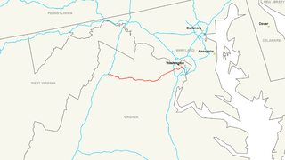
| 02:25, 11 February 2015 | TRVA Map US522 320px.png (file) |  |
30 KB | QDP2012 | Map of US 522 in Virginia License: http://en.wikipedia.org/wiki/File:US_522_%28VA%29_map.svg Creator: http://commons.wikimedia.org/wiki/User:25or6to4 Source: ImgFile=http://upload.wikimedia.org/wikipedia/commons/thumb/5/5c/US_522_%28VA%29_map.svg/320px | 1 |
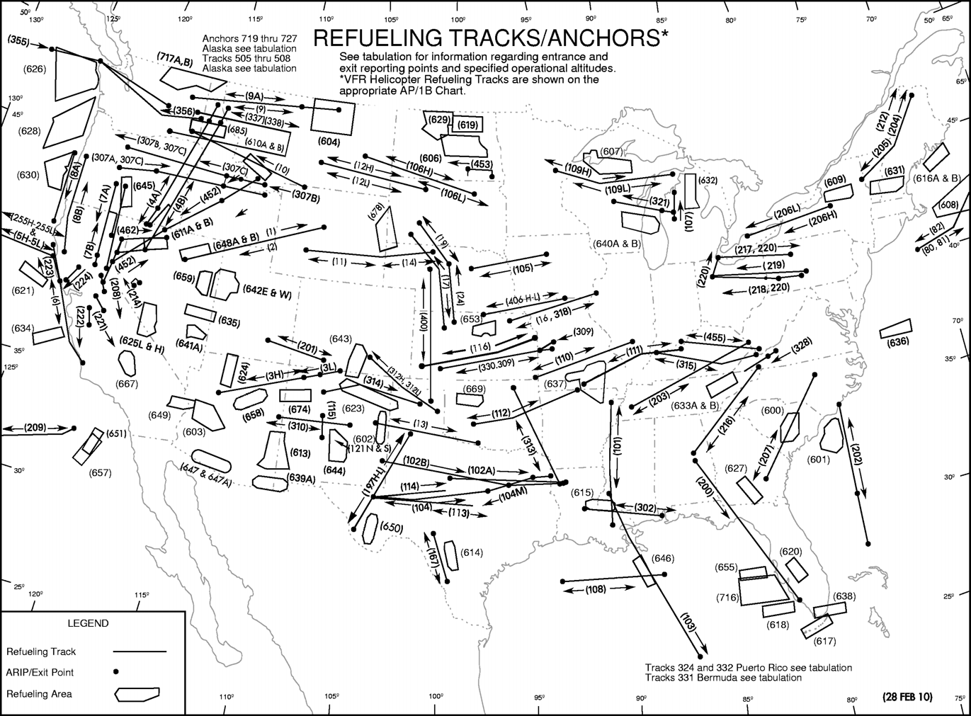
| 22:13, 26 October 2014 | Ar map sep14.png (file) |  |
636 KB | Ke5tlf | Refueling Tracks/Anchors | 1 |
| 11:45, 23 October 2014 | 159th FW.png (file) |  |
54 KB | Ke5tlf | 159th Fighter Wing (159 FW) emblem | 1 |
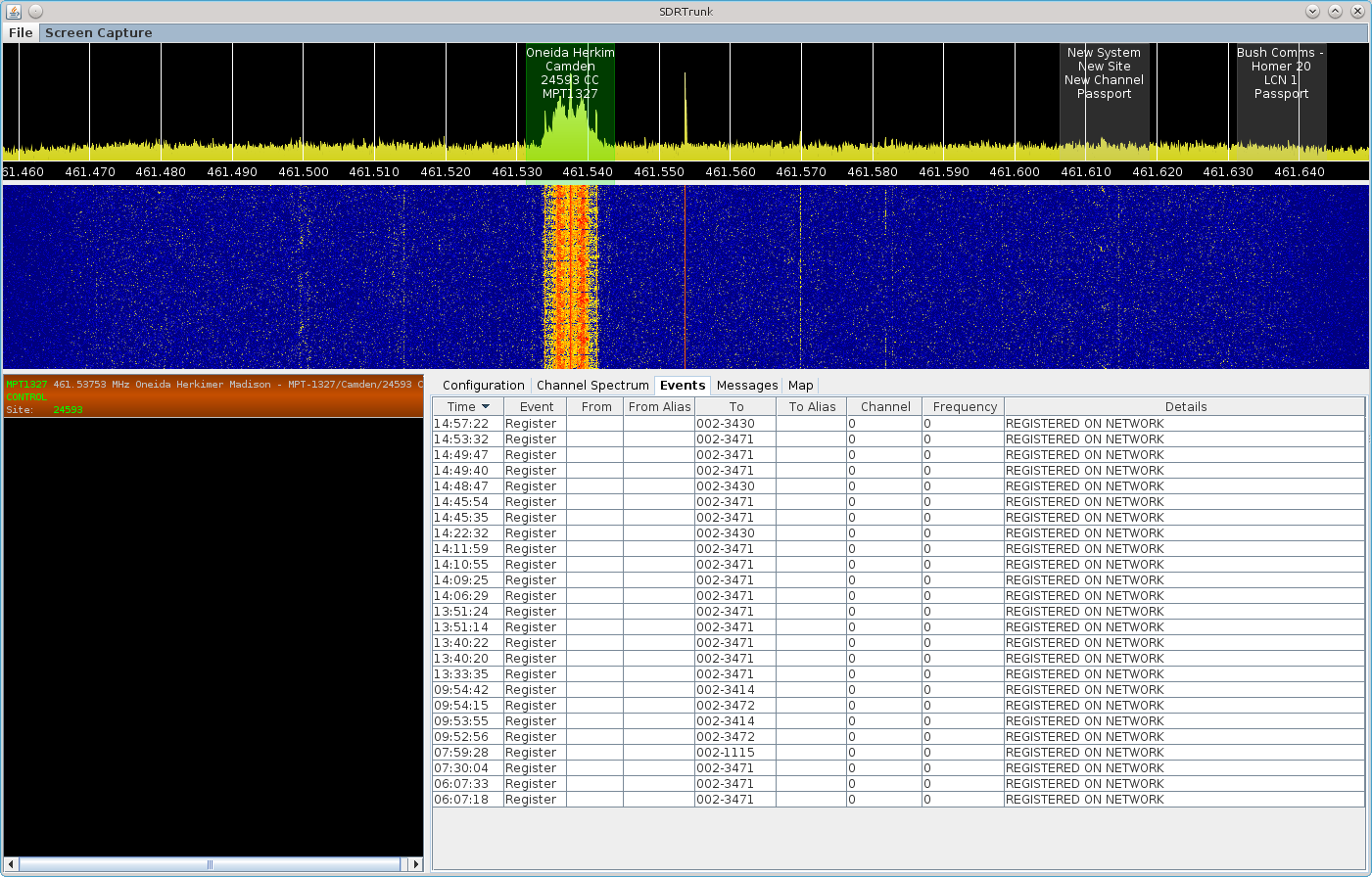
| 17:40, 4 September 2014 | Sid 8021 system testing.png (file) |  |
201 KB | Dsheirer | SDRTrunk - system radio testing and registration for new MPT1327 network | 1 |
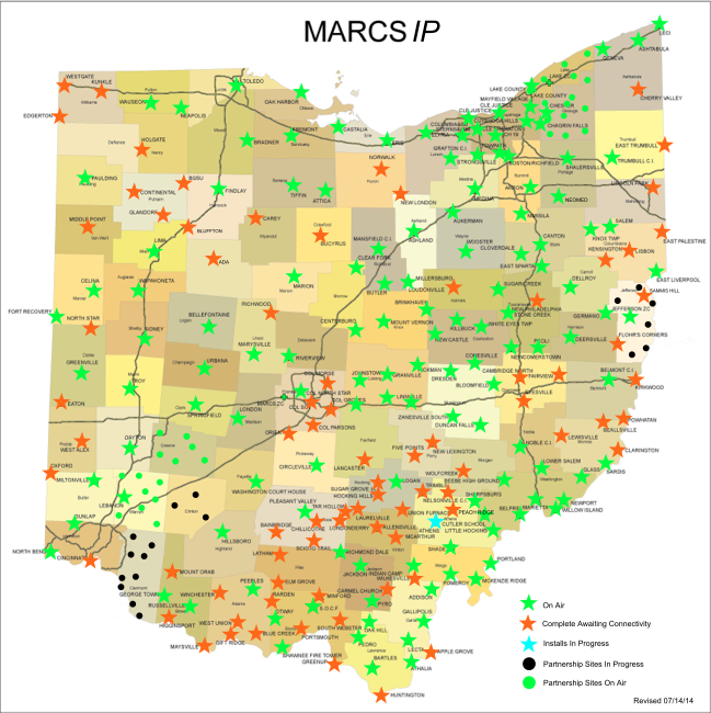
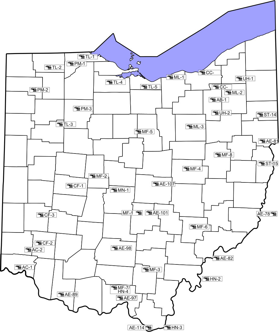
| 21:00, 24 July 2014 | MARCS-IPMap071414.png (file) |  |
339 KB | Wa8pyr | Ohio MARCS-IP Sites and status July 14, 2014 | 1 |
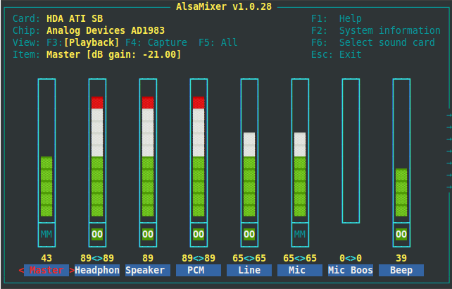
| 13:55, 19 July 2014 | ALSAMixer.png (file) |  |
31 KB | Jawnah | View of the ALSA mixing console from the alsamixer utility on a Debian system. | 1 |
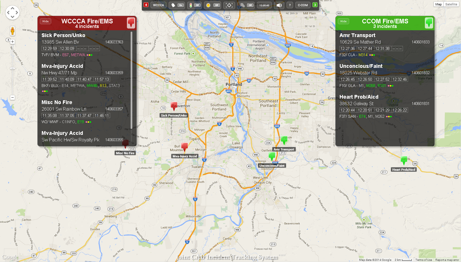
| 14:38, 22 June 2014 | Jits cad may2013.png (file) |  |
744 KB | PMJ2kx | Revised layout as of June 2014 | 2 |
| 15:33, 18 June 2014 | Rs1.PNG (file) |  |
49 KB | Butelsoftware | 1 | |
| 10:43, 13 June 2014 | W5DIb.png (file) |  |
1.08 MB | Sporter | W5DI linked repeater system | 1 |
| 18:13, 10 May 2014 | Rtlsdr.png (file) |  |
73 KB | Blantonl | 1 | |
| 09:17, 24 March 2014 | Logo tw4 150x150.png (file) |  |
7 KB | Ke5tlf | Training Air Wing 4 insignia | 1 |
| 09:16, 24 March 2014 | Logo tw2 150x150.png (file) |  |
6 KB | Ke5tlf | Training Air Wing 2 insignia | 1 |
| 11:42, 23 March 2014 | Logo vt9 150x150.png (file) |  |
10 KB | Ke5tlf | Training Squadron NINE insignia | 1 |
| 11:41, 23 March 2014 | Logo vt7 150x150.png (file) |  |
11 KB | Ke5tlf | Training Squadron SEVEN insignia | 1 |
| 11:39, 23 March 2014 | Logo tw1 150x150.png (file) |  |
6 KB | Ke5tlf | Training Air Wing 1 insignia | 1 |
| 07:00, 23 March 2014 | Logo vt6 150x150.png (file) |  |
9 KB | Ke5tlf | Training Squadron SIX insignia | 1 |
| 06:59, 23 March 2014 | Logo vt3 150x150.png (file) |  |
11 KB | Ke5tlf | Training Squadron THREE insignia | 1 |
| 06:59, 23 March 2014 | Logo vt2 150x150.png (file) |  |
10 KB | Ke5tlf | Training Squadron TWO insignia | 1 |
| 22:36, 21 March 2014 | Blue Angels Insignia.png (file) |  |
85 KB | Ke5tlf | Blue Angels Insignia | 1 |
| 21:37, 21 March 2014 | 455th FTS Emblem.png (file) |  |
219 KB | Ke5tlf | 455th Flying Training Squadron insignia | 1 |
| 21:36, 21 March 2014 | 451st FTS Emblem.png (file) |  |
213 KB | Ke5tlf | 451st Flying Training Squadron insignia | 1 |
| 21:26, 21 March 2014 | 479th FTS logo.png (file) | 178 KB | Ke5tlf | 479th Flying Training Group | 1 | |
| 21:23, 21 March 2014 | VT-86 logo.png (file) | 22 KB | Ke5tlf | Training Squadron EIGHT SIX insignia | 1 | |
| 21:18, 12 September 2013 | IpnHeader.png (file) |  |
141 KB | Blantonl | 1 | |
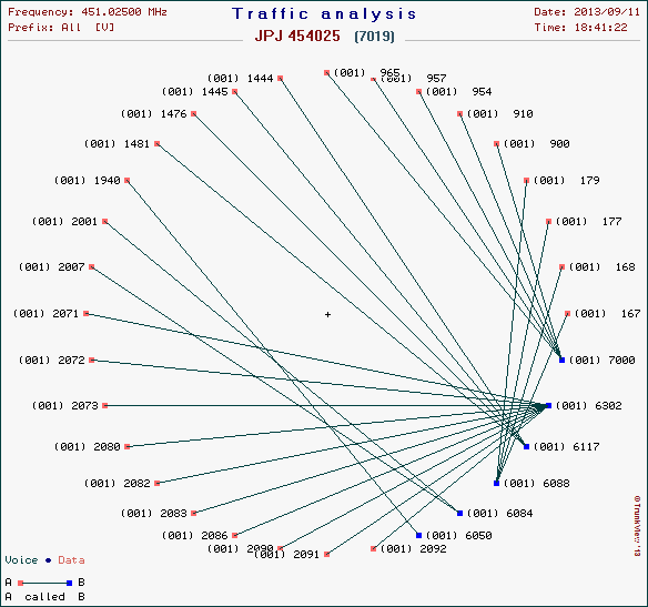
| 08:36, 12 September 2013 | AnalyaiaJPJ.png (file) |  |
16 KB | Virtualspin315 | 28697 (7019) Smith Hill - Utica Traffic analysis | 1 |
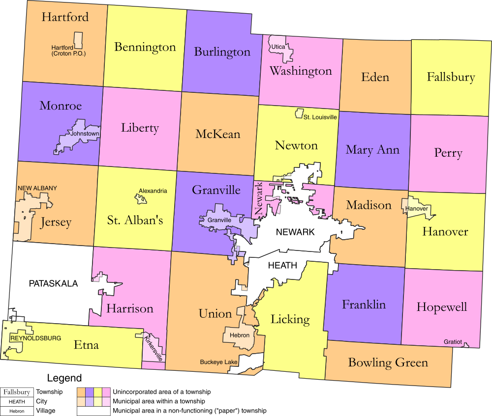
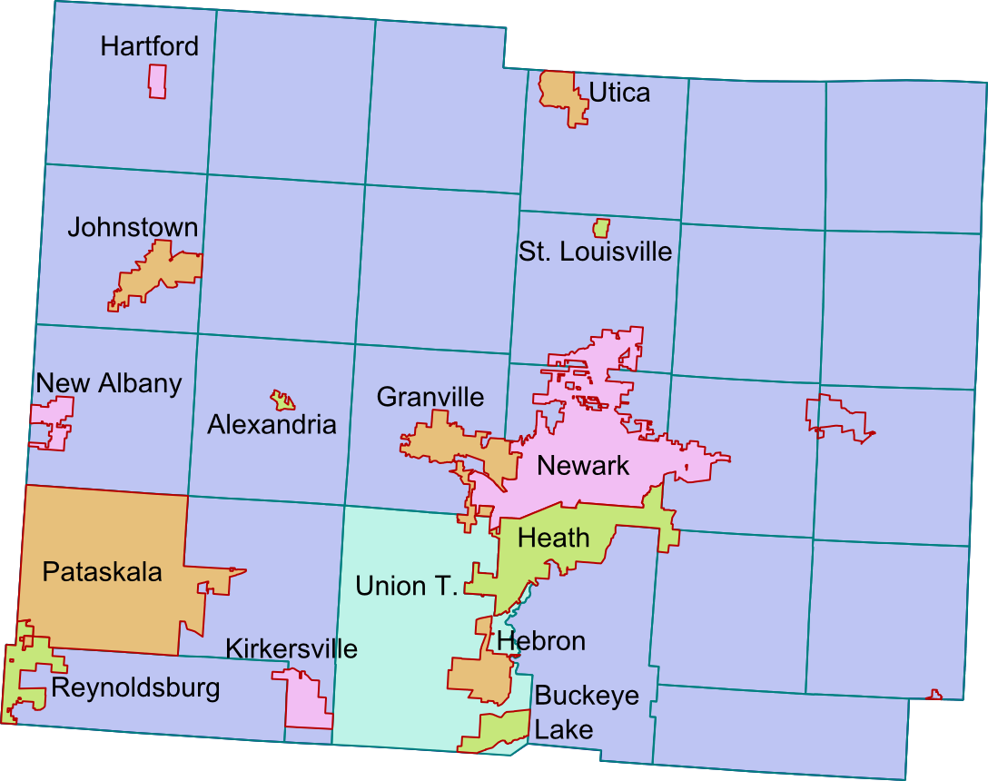
| 18:23, 27 August 2013 | Licking County Map.png (file) |  |
226 KB | Ibagli | Change Buckeye Lake | 3 |
| 20:05, 22 May 2013 | RC PSCS Logo.png (file) | 128 KB | Chauffeur6 | 1 | ||
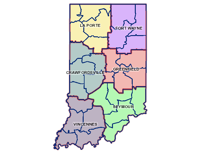
| 04:01, 18 April 2013 | Indiana DOT District Map.png (file) |  |
11 KB | Scannerfreak | 1 | |
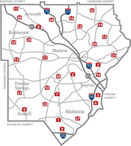
| 22:49, 17 March 2013 | CCFD Stations.png (file) |  |
72 KB | B7spectra | Locations of Cobb County Fire Stations | 1 |
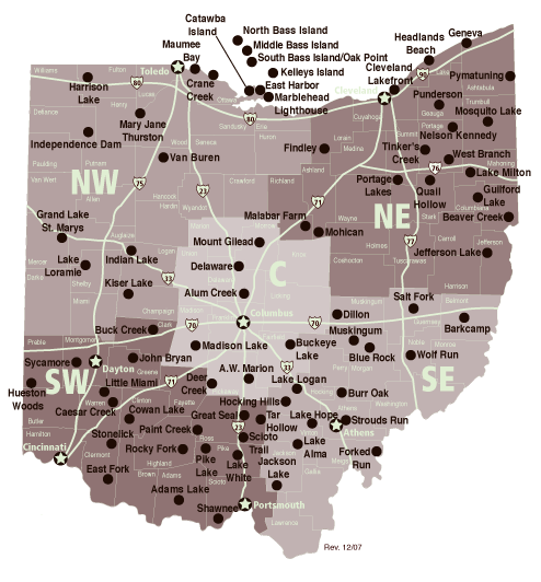
| 17:51, 13 February 2013 | Ohio Medical Helicopters.png (file) |  |
198 KB | Ibagli | Updates | 7 |
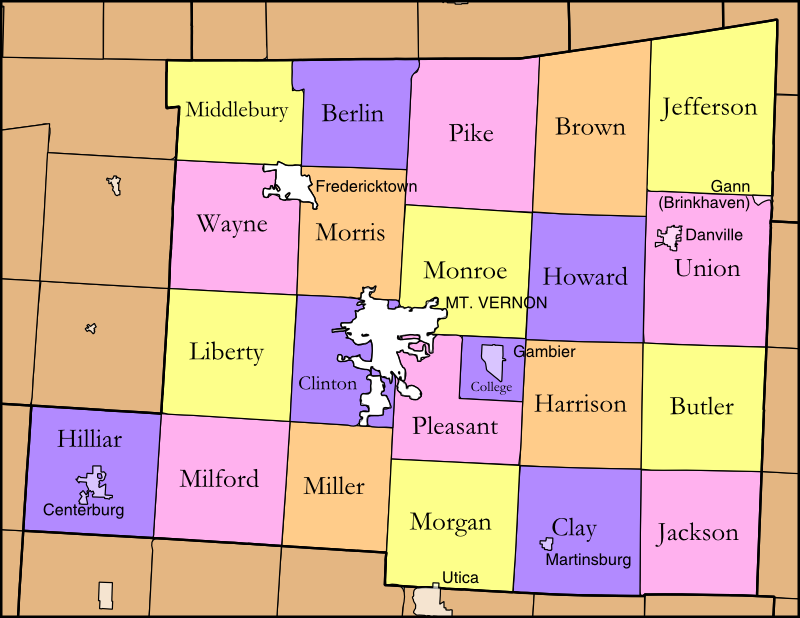
| 18:42, 11 December 2012 | Knox County Map.png (file) |  |
145 KB | Ibagli | 2 | |
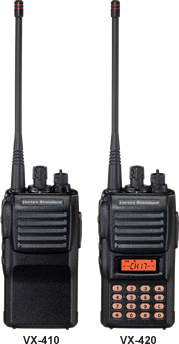
| 19:40, 29 November 2012 | VX-520.png (file) |  |
30 KB | Kc0wkp | 1 | |
| 19:20, 29 November 2012 | 420.png (file) |  |
63 KB | Kc0wkp | 1 | |
| 15:28, 9 November 2012 | APX7000TMSnotsentsymbol.png (file) |  |
991 bytes | Wqoj972 | APX series TMS message not sent symbol. | 1 |
| 15:25, 9 November 2012 | APX7000TMSsentsymbol.png (file) |  |
909 bytes | Wqoj972 | APX series TMS message sent symbol. | 1 |
| 15:22, 9 November 2012 | APX7000TMSpriority+requrepl.png (file) |  |
1 KB | Wqoj972 | APX series TMS notification of priority message received requesting reply. | 1 |
| 15:20, 9 November 2012 | APX7000TMSrequreply.png (file) |  |
1 KB | Wqoj972 | APX series TMS message received requesting reply. | 1 |
| 15:12, 9 November 2012 | APX7000TMSpriorityRx.png (file) |  |
1,013 bytes | Wqoj972 | APX series TMS priority message received symbol. | 1 |
| 15:11, 9 November 2012 | APX7000TMSreceivedsymbol.png (file) |  |
725 bytes | Wqoj972 | APX series TMS received symbol. | 1 |
| 14:59, 9 November 2012 | APX7000votingscansymbol.png (file) |  |
1,023 bytes | Wqoj972 | APX series voting scan symbol. | 1 |
| 14:57, 9 November 2012 | APX7000priorityscansymbol.png (file) |  |
949 bytes | Wqoj972 | APX series priority scan symbol. | 1 |
| 14:56, 9 November 2012 | APX7000scansymbol.png (file) |  |
769 bytes | Wqoj972 | APX series scan symbol | 1 |
| 14:52, 9 November 2012 | APX7000RSSIsymbol.png (file) |  |
782 bytes | Wqoj972 | APX series RSSI symbol. | 1 |
| 14:50, 9 November 2012 | APX7000TxSymbol.png (file) |  |
1 KB | Wqoj972 | APX series Tx symbol | 1 |
| 14:44, 9 November 2012 | APX7000RxSymbol.png (file) |  |
1 KB | Wqoj972 | APX series Rx symbol. | 1 |
| 14:40, 9 November 2012 | APX7000AESSecureOperation.png (file) |  |
2 KB | Wqoj972 | An APX series AES secure operation symbol | 1 |
| 14:38, 9 November 2012 | APX7000SecureOperation.png (file) |  |
1 KB | Wqoj972 | An APX series secure hardware operation symbol. | 1 |
| 14:35, 9 November 2012 | APX7000Monitorsymbol.png (file) |  |
597 bytes | Wqoj972 | APX series monitor (carrier squelch) symbol (conventional only). | 1 |
| 14:32, 9 November 2012 | APX7000LowPowersymbol.png (file) |  |
343 bytes | Wqoj972 | APX series low power symbol | 1 |
| 14:31, 9 November 2012 | APX7000HighPower.png (file) |  |
320 bytes | Wqoj972 | APX series high power symbol | 1 |
| 14:29, 9 November 2012 | APX7000TAsymbol.png (file) |  |
619 bytes | Wqoj972 | APX series Talkaround/direct mode symbol. | 1 |
| 14:17, 9 November 2012 | APX7000CallReceived.png (file) |  |
1 KB | Wqoj972 | The APX series Call Received notification. | 1 |
| 14:14, 9 November 2012 | APX7000BattMeter.png (file) |  |
448 bytes | Wqoj972 | APX series Battery meter. | 1 |
| 14:12, 9 November 2012 | APX7000LowBattMeter.png (file) |  |
418 bytes | Wqoj972 | APX series low-battery meter symbol. | 1 |
| 14:08, 9 November 2012 | ARSdata-InTransit.png (file) | 739 bytes | Wqoj972 | APX series ARS data symbol. Data in transit. | 1 | |
| 14:00, 9 November 2012 | ARSdata-LoggedOut.png (file) |  |
586 bytes | Wqoj972 | ARS data symbol when logged-out of ARS. | 1 |
| 19:30, 1 November 2012 | ER2.png (file) |  |
415 KB | Edgerift | 2 | |
| 19:27, 1 November 2012 | ER1.png (file) |  |
108 KB | Edgerift | 6 | |
| 02:01, 22 August 2012 | MadisonEMS.png (file) |  |
130 KB | Ibagli | 1 | |
| 21:34, 21 July 2012 | MARCS Map.png (file) |  |
466 KB | Ibagli | Manchester | 21 |
| 01:41, 18 July 2012 | PasadenaCTT.png (file) |  |
62 KB | Jlanfn | Settings for using Win96 to program Pasadena, CA ICIS P25 site. | 1 |
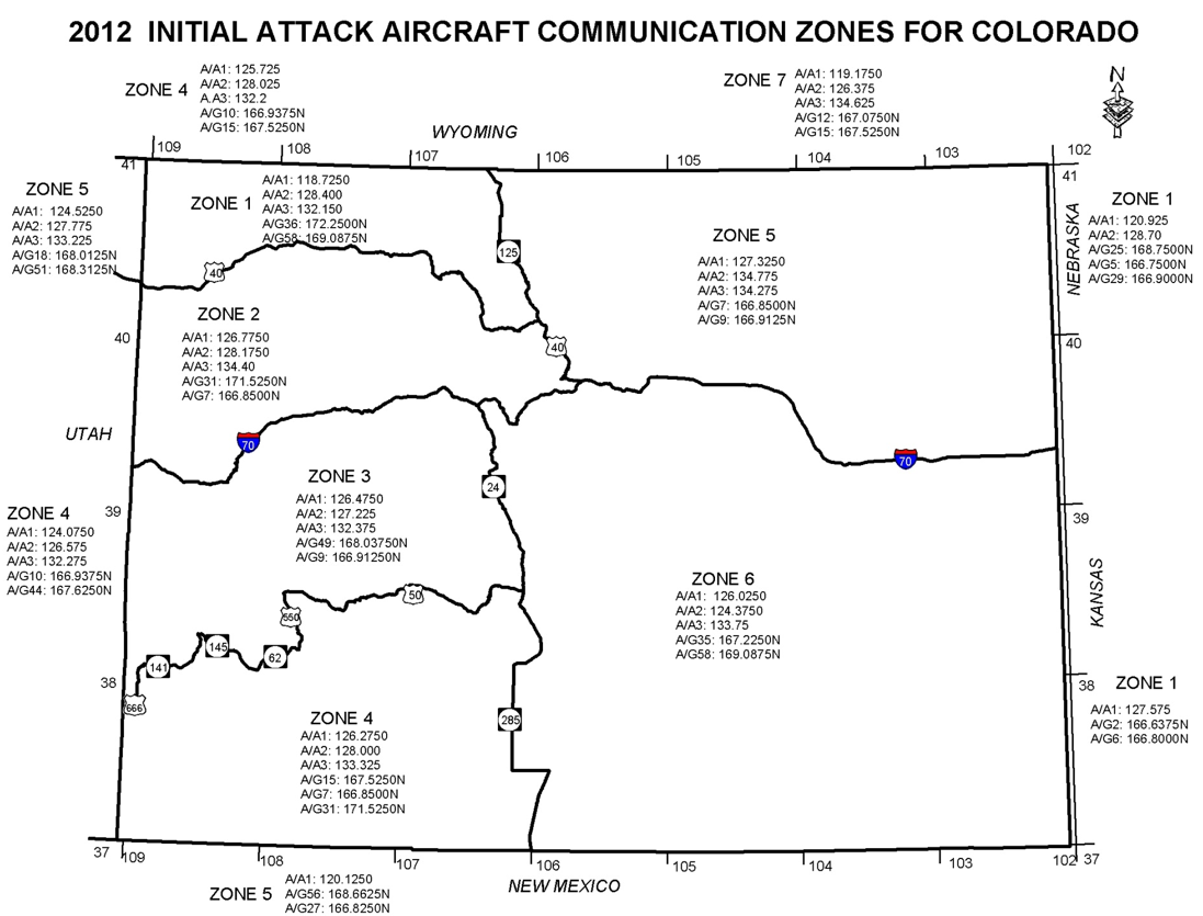
| 11:10, 28 June 2012 | 2012InitialAttack.png (file) |  |
301 KB | Greenthumb | 1 | |
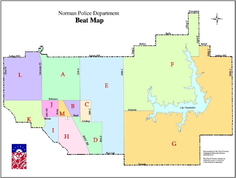
| 17:33, 9 June 2012 | NPD-Beat-Map.PNG (file) |  |
187 KB | Plaws | Norman, Oklahoma, Police Dept beat map. Current as of 2011. | 1 |
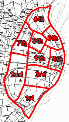
| 16:22, 19 May 2012 | Stlcitydists.png (file) |  |
19 KB | Qubix | St. Louis Metropolitan Police Department | 1 |
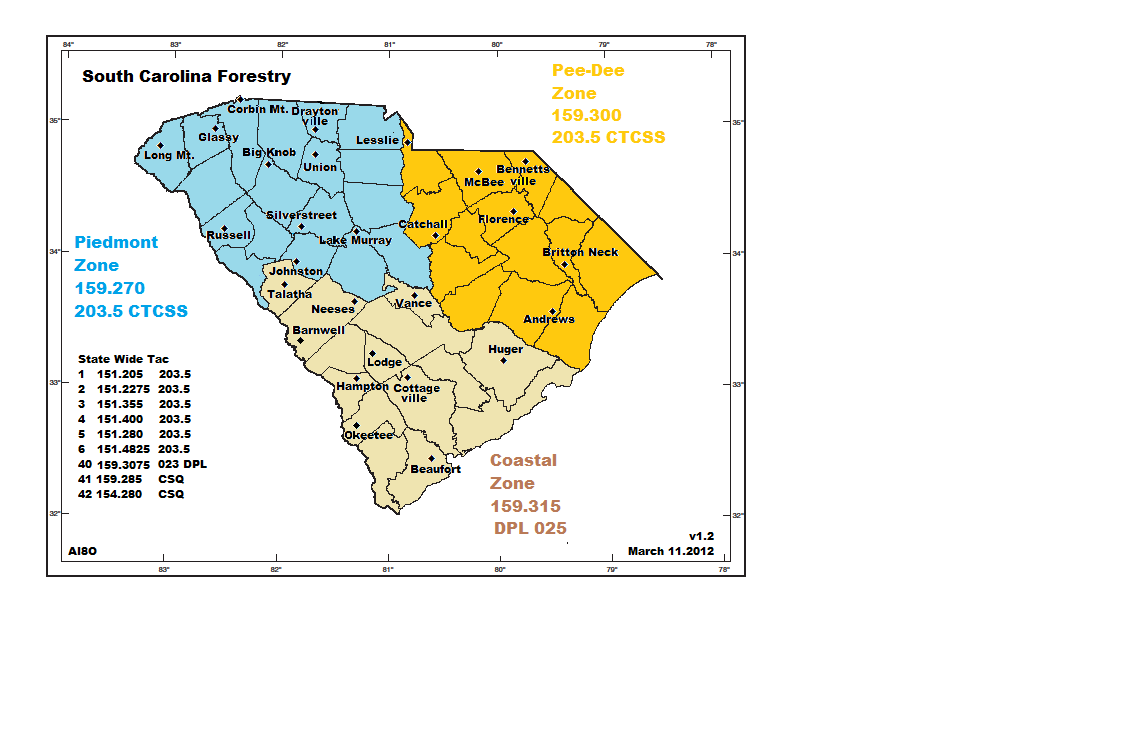
| 17:58, 11 March 2012 | SC Forestry Zones.png (file) |  |
72 KB | Ai8o | 2 | |
| 09:53, 5 March 2012 | 911Scanner6.png (file) |  |
73 KB | Hermanm | 1 | |
| 09:53, 5 March 2012 | 911Scanner5.png (file) |  |
125 KB | Hermanm | 1 | |
| 09:53, 5 March 2012 | 911Scanner4.png (file) |  |
108 KB | Hermanm | 1 | |
| 09:52, 5 March 2012 | 911Scanner3.png (file) |  |
103 KB | Hermanm | 1 | |
| 09:52, 5 March 2012 | 911Scanner2.png (file) |  |
30 KB | Hermanm | 1 | |
| 09:51, 5 March 2012 | 911Scanner1.png (file) |  |
101 KB | Hermanm | 1 | |
| 23:28, 3 March 2012 | Holmes Fire.png (file) |  |
39 KB | Ibagli | Holmes County Fire Map | 1 |
| 13:48, 12 February 2012 | ScannerRadioDeluxe3.png (file) |  |
373 KB | GordonE | 1 | |
| 13:47, 12 February 2012 | ScannerRadioDeluxe2.png (file) |  |
129 KB | GordonE | 1 | |
| 13:46, 12 February 2012 | ScannerRadioDeluxe1.png (file) |  |
645 KB | GordonE | 1 | |
| 14:01, 13 January 2012 | Thirdscreen.png (file) |  |
302 KB | Cmilian | 1 | |
| 13:57, 13 January 2012 | Fourthscreen.png (file) |  |
295 KB | Cmilian | 1 | |
| 13:56, 13 January 2012 | Secondscreen.png (file) |  |
290 KB | Cmilian | 2 | |
| 13:52, 13 January 2012 | Mainscreen.png (file) |  |
333 KB | Cmilian | 1 | |
| 12:19, 13 January 2012 | PoliceMonitor5.png (file) |  |
91 KB | Ggraves | Police Monitor App - Browse Feeds (State View) | 1 |
| 12:19, 13 January 2012 | PoliceMonitor4.png (file) |  |
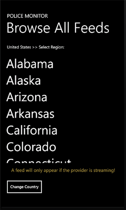
99 KB | Ggraves | Police Monitor App - Browse Feeds | 1 |
| 12:18, 13 January 2012 | PoliceMonitor3.png (file) |  |
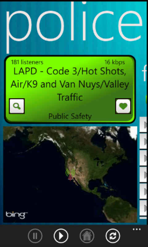
73 KB | Ggraves | Police Monitor App - Feed Player | 1 |
| 12:18, 13 January 2012 | PoliceMonitor2.png (file) |  |
113 KB | Ggraves | Police Monitor App - Top Feeds | 1 |
| 12:16, 13 January 2012 | PoliceMonitor1.png (file) |  |
89 KB | Ggraves | Police Monitor App - Select Action Page | 1 |
| 08:18, 27 December 2011 | System map.png (file) |  |
591 KB | Mciupa | 1 | |
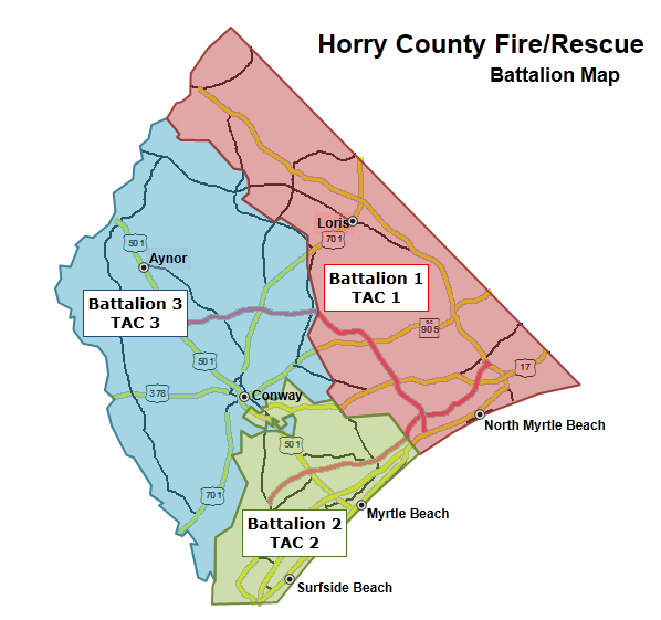
| 22:43, 13 December 2011 | HCFR Batt Map.png (file) |  |
57 KB | Brycel | Horry Co (SC) Fire/Rescue Battalion Map | 1 |
| 19:48, 1 October 2011 | Saint Tammany Louisiana.png (file) |  |
207 KB | MarkHinton | A Google hybrid map showing St. Tammany Parish, Louisiana | 1 |
| 14:18, 2 August 2011 | CPD-7 Zone5.png (file) |  |
356 KB | Ibagli | 1 | |
| 14:18, 2 August 2011 | CPD-5 Zone3.png (file) |  |
414 KB | Ibagli | 1 | |
| 14:17, 2 August 2011 | CPD-6 Zone4.png (file) |  |
275 KB | Ibagli | 1 | |
| 14:17, 2 August 2011 | CPD-4 Zone2.png (file) |  |
393 KB | Ibagli | 1 | |
| 14:17, 2 August 2011 | CPD-3 Zone1.png (file) |  |
349 KB | Ibagli | 1 | |
| 14:17, 2 August 2011 | CPD-2 Precincts.png (file) |  |
132 KB | Ibagli | 1 | |
| 14:07, 2 August 2011 | CPD-1 Zones.png (file) |  |
142 KB | Ibagli | 2 | |
| 12:41, 22 May 2011 | RRdevice6.png (file) |  |
170 KB | Appfaucet | 1 | |
| 12:38, 22 May 2011 | RRdevice2.png (file) |  |
152 KB | Appfaucet | 1 | |
| 12:37, 22 May 2011 | RRdevice.png (file) |  |
138 KB | Appfaucet | 1 | |
| 12:37, 22 May 2011 | RRdevice1.png (file) |  |
165 KB | Appfaucet | 1 | |
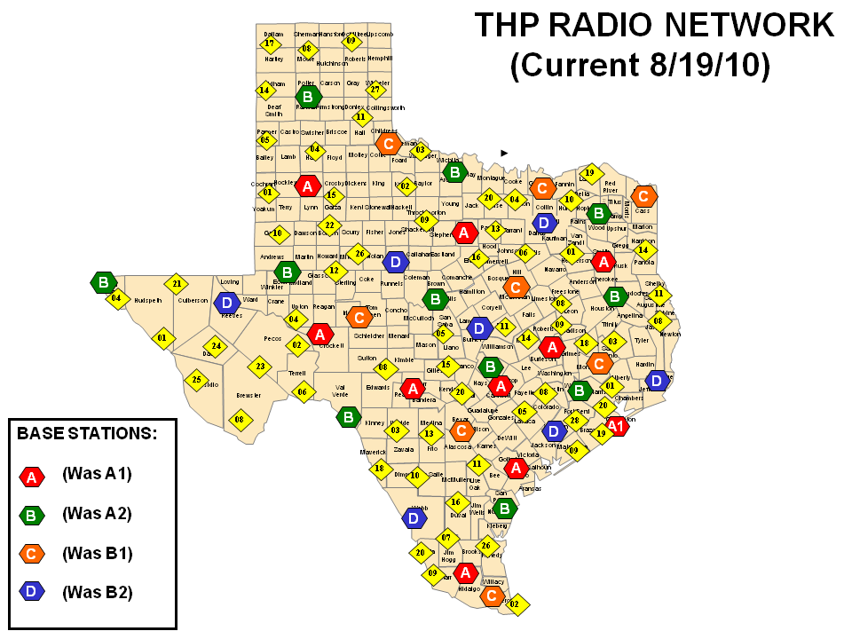
| 21:01, 22 March 2011 | STATE MAP - NEW NAMES - ALL THP STATIONS 7-28-10.png (file) |  |
125 KB | Ericcarlson | Texas DPS Radio Network Map, 8/19/2010 | 1 |
| 11:42, 24 February 2011 | Bb3.png (file) |  |
73 KB | GordonE | 1 | |
| 11:42, 24 February 2011 | Bb2.png (file) |  |
86 KB | GordonE | 1 | |
| 11:42, 24 February 2011 | Bb1.png (file) |  |
31 KB | GordonE | 1 | |
| 22:13, 23 February 2011 | ScannerRadioScreen3.png (file) |  |
68 KB | GordonE | 1 | |
| 22:12, 23 February 2011 | ScannerRadioScreen2.png (file) |  |
49 KB | GordonE | 5 | |
| 22:12, 23 February 2011 | ScannerRadioScreen1.png (file) |  |
92 KB | GordonE | 6 | |
| 17:00, 28 January 2011 | 200px-Metrolinx logo.png (file) | 18 KB | Mciupa | 1 | ||
| 13:34, 28 January 2011 | MiWay Header780x116.png (file) | 19 KB | Mciupa | 2 | ||
| 09:17, 20 January 2011 | Callboxxt.png (file) |  |
68 KB | Donslow | Example of a MURS Call Box XT units without keypad. | 1 |
| 08:24, 11 January 2011 | Hpusb.PNG (file) |  |
41 KB | Butelsoftware | 1 | |
| 11:23, 22 December 2010 | MmtstcQR.png (file) |  |
327 bytes | Mmtstc | 1 | |
| 11:19, 5 December 2010 | Spirit-Logo.png (file) | 32 KB | Northerner71 | 1 | ||
| 15:47, 4 December 2010 | Licking County lowband repeaters.png (file) |  |
209 KB | Ibagli | 3 | |
| 11:59, 4 December 2010 | PR3.png (file) |  |
236 KB | Iphonedev32 | 2 | |
| 11:57, 4 December 2010 | PR2.png (file) |  |
310 KB | Iphonedev32 | 2 | |
| 11:52, 4 December 2010 | PR1.png (file) |  |
311 KB | Iphonedev32 | 2 | |
| 03:28, 21 November 2010 | Southern Ontario County Map Blank.png (file) | 582 KB | Ibagli | 1 | ||
| 17:52, 8 September 2010 | Digiscanner2.png (file) |  |
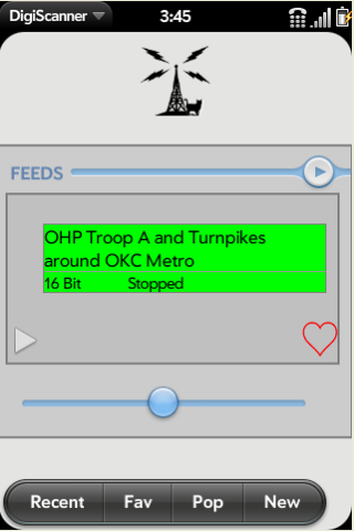
27 KB | Merphie | Search page in DigiScanner | 1 |
| 17:49, 8 September 2010 | Digiscanner4.png (file) |  |
57 KB | Merphie | Feed list page for DigiScanner | 1 |
| 17:46, 8 September 2010 | Digiscanner1.png (file) |  |
31 KB | Merphie | Screen shot of DigiScanner | 1 |
| 17:44, 8 September 2010 | Digiscanner.png (file) |  |
4 KB | Merphie | DigiScanner Logo | 1 |
| 21:47, 1 September 2010 | OCICS20100901.png (file) |  |
106 KB | Ianew | OCICS control channel data as viewed with UniTrunker. | 1 |
| 19:52, 1 August 2010 | Kitsap.png (file) |  |
18 KB | Madhatter66 | Location of Kitsap County | 1 |
| 00:38, 11 July 2010 | BotetourtFirstDueMap.png (file) |  |
15 KB | Rzelenske | Image of Botetourt County's Fire and Rescue first due dispatch map. Image taken from http://yourbces.org/page17.html No copyright infrigement intended. | 1 |
| 21:17, 10 July 2010 | Cuyahoga County RR.png (file) |  |
39 KB | Ibagli | 1 | |
| 08:33, 6 June 2010 | Arc20.png (file) |  |
81 KB | Butelsoftware | 1 | |
| 20:22, 29 May 2010 | 150px-Air Canada Centre svg.png (file) |  |
4 KB | Mciupa | 1 | |
| 09:02, 7 May 2010 | 712px-Viva York Region route map svg.png (file) |  |
128 KB | Mciupa | 1 | |
| 21:49, 6 May 2010 | 650px-TTC streetcarmap-2005.png (file) |  |
115 KB | Mciupa | 1 | |
| 21:46, 6 May 2010 | 750px-TTCsubwayRTmap-2007 svg.png (file) |  |
74 KB | Mciupa | 3 | |
| 19:41, 27 April 2010 | Wiki.png (file) |  |
22 KB | Mciupa | 1 | |
| 18:18, 8 April 2010 | 300px-Map of Clark County Ohio With Municipal and Township Labels.PNG (file) |  |
68 KB | Radioscan | Map of Clark County, Ohio | 1 |
| 14:41, 26 March 2010 | Redwood MN Map.PNG (file) |  |
57 KB | Mmtstc | 1 | |
| 08:25, 18 March 2010 | PSNHServiceTerritory.png (file) |  |
410 KB | Gonorth | New Hampshire PSNH Service Territory | 1 |
| 15:04, 24 February 2010 | Screenshot3 SR.png (file) |  |
60 KB | Neptune2000 | Station List | 1 |
| 15:01, 24 February 2010 | Screenshot2 SR.png (file) |  |
35 KB | Neptune2000 | Categories | 1 |
| 14:31, 24 February 2010 | Screenshot2 en.png (file) |  |
59 KB | Neptune2000 | RadioReference list of Stations | 1 |
| 16:36, 9 February 2010 | South.png (file) |  |
229 bytes | Mmtstc | 1 | |
| 16:36, 9 February 2010 | North.png (file) |  |
232 bytes | Mmtstc | 1 | |
| 16:36, 9 February 2010 | East.png (file) |  |
207 bytes | Mmtstc | 1 | |
| 16:35, 9 February 2010 | West.png (file) |  |
209 bytes | Mmtstc | 1 | |
| 16:31, 9 February 2010 | Compass rose pale-50x50.png (file) |  |
5 KB | Mmtstc | 1 | |
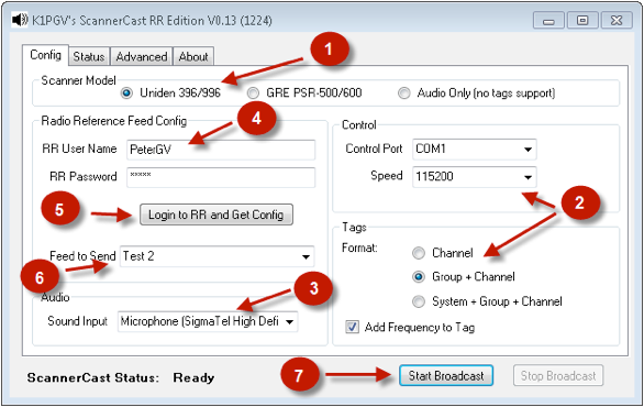
| 11:56, 15 January 2010 | ScannerCastConfig.png (file) |  |
81 KB | Blantonl | 1 | |
| 18:47, 31 December 2009 | Berry College PD signal codes.png (file) |  |
6 KB | Ka3jjz | 1 | |
| 12:46, 21 December 2009 | Police Stream.png (file) |  |
2 KB | Richtidd | 1 | |
| 16:32, 9 December 2009 | Screen3.png (file) |  |
80 KB | Bear105 | 1 | |
| 16:32, 9 December 2009 | Screen1.png (file) |  |
111 KB | Bear105 | 1 | |
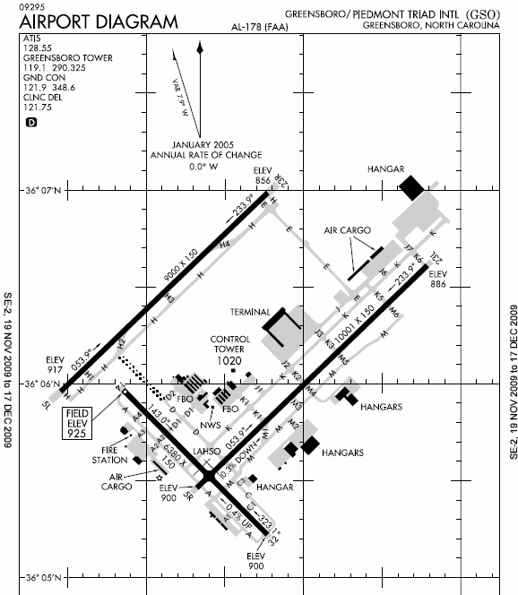
| 13:39, 7 December 2009 | GSO Airport Diagram.png (file) |  |
78 KB | Kendrik578 | 1 | |
| 07:09, 28 November 2009 | RR Browser Preview.png (file) |  |
43 KB | Ka3jjz | 1 | |
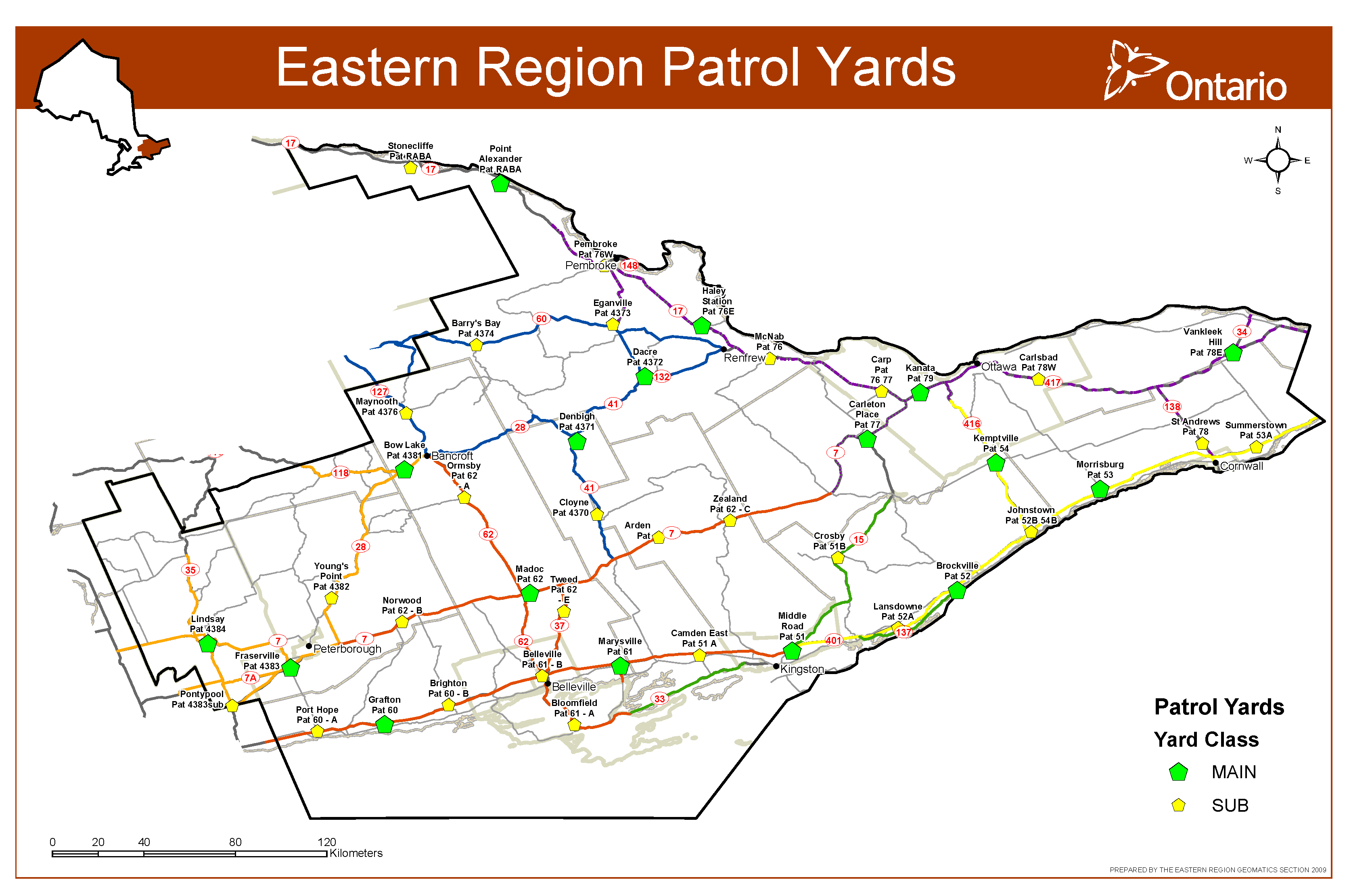
| 14:54, 25 November 2009 | Eastern Region Patrol Yards.png (file) |  |
243 KB | Bezking | 1 | |
| 00:27, 17 November 2009 | Minnesota County Map Blank.png (file) | 69 KB | Ibagli | 1 | ||
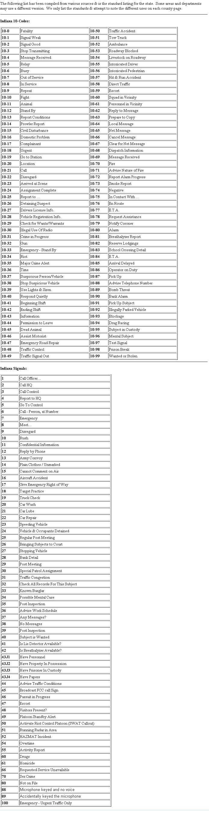
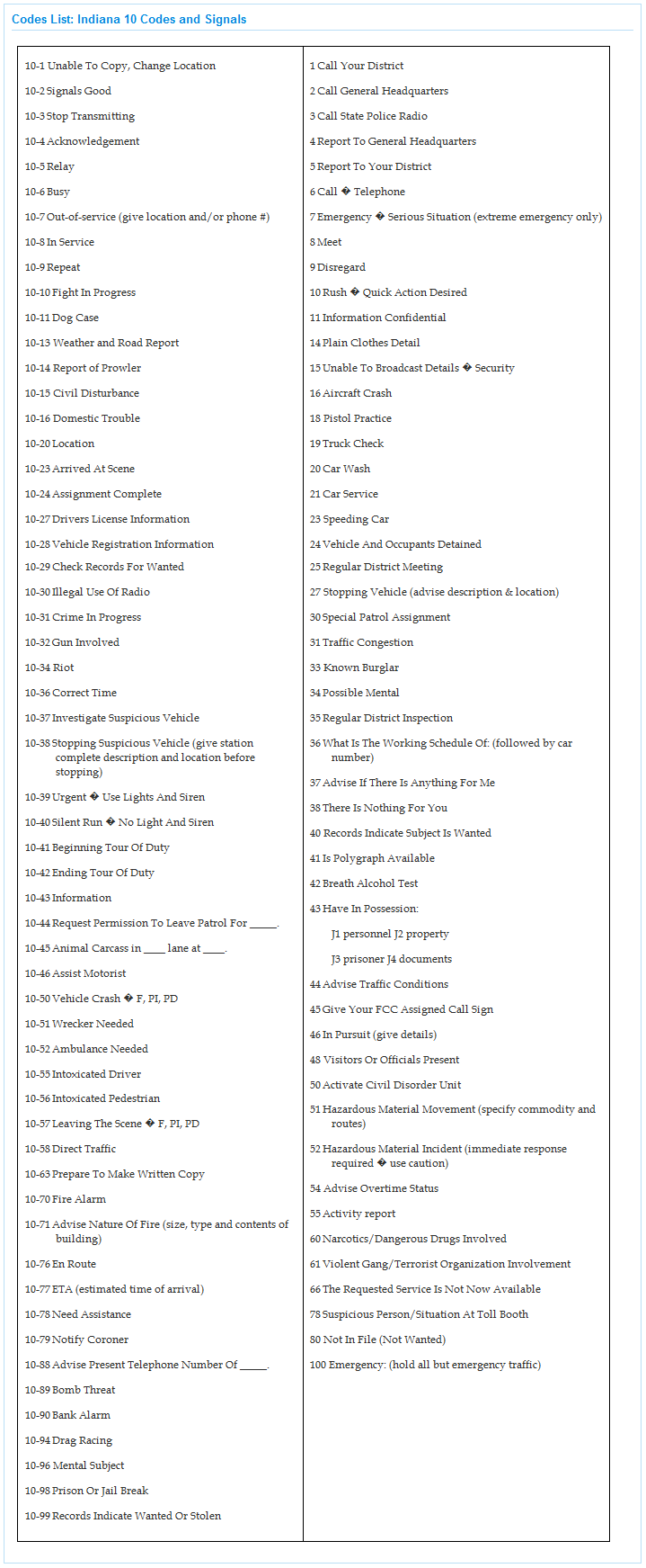
| 12:48, 8 November 2009 | Indiana 10-Codes and Signals.png (file) |  |
72 KB | Ka3jjz | 1 | |
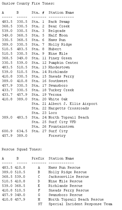
| 20:09, 7 November 2009 | Onslow County Fire EMS Tones.png (file) |  |
14 KB | Ka3jjz | 1 | |
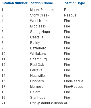
| 07:36, 7 November 2009 | Nash County Fire and Rescue.png (file) |  |
6 KB | Ka3jjz | 1 | |
| 19:57, 4 November 2009 | Orangeburg Co. Status Codes.png (file) |  |
2 KB | Ka3jjz | 1 | |
| 19:56, 4 November 2009 | Orangeburg Co. Signals.png (file) |  |
8 KB | Ka3jjz | 1 | |
| 19:55, 4 November 2009 | Orangeburg Co. 10-codes.png (file) |  |
19 KB | Ka3jjz | 1 | |
| 17:44, 4 November 2009 | Clay County Fire Stations.png (file) |  |
3 KB | Ka3jjz | 1 | |
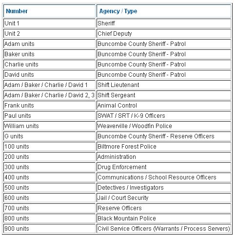
| 05:36, 3 November 2009 | Buncombe county LE Unit Numbers.png (file) |  |
12 KB | Ka3jjz | 1 | |
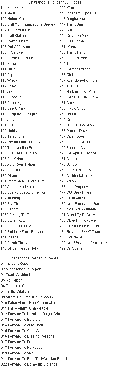
| 20:58, 30 October 2009 | Chattanooga Police 400 Codes & D Codes.png (file) |  |
25 KB | Ka3jjz | 1 | |
| 19:18, 26 October 2009 | Mshpmap.png (file) |  |
31 KB | Starcom21 | missouRi hIHgway patrol map with troop areas | 1 |
| 11:42, 25 October 2009 | York County Fire Tones.png (file) |  |
4 KB | Ka3jjz | 1 | |
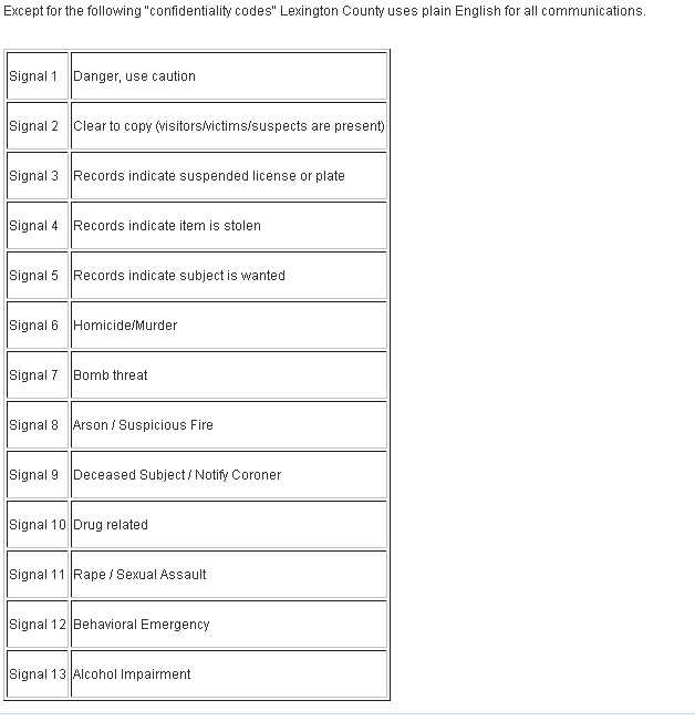
| 11:32, 25 October 2009 | Lexington County Public Safety Signal Codes.png (file) |  |
12 KB | Ka3jjz | 1 | |
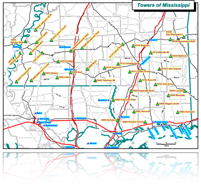
| 20:48, 18 October 2009 | MSWIN Current Towers.png (file) |  |
402 KB | Ke5tlf | 1 | |
| 00:11, 18 October 2009 | Precint-map.png (file) |  |
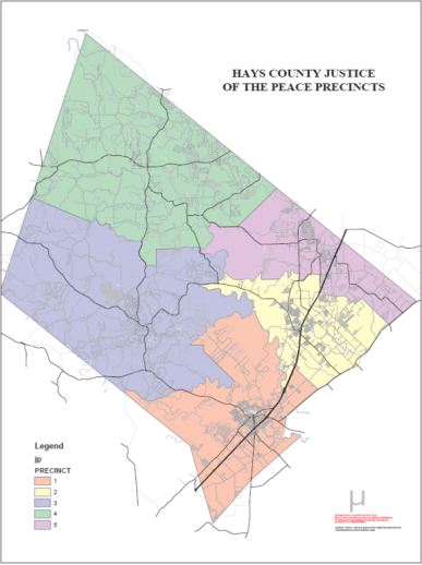
142 KB | Texasemt13 | Hays County Precinct Map | 1 |
| 14:11, 12 October 2009 | Ellis County Call Signals.PNG (file) |  |
32 KB | Ka3jjz | 1 | |
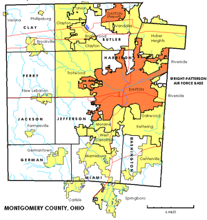
| 14:15, 11 October 2009 | 300px-Montgomerytownships.PNG (file) |  |
100 KB | Radioscan | Map of Montgomery County, Ohio townships, cities and villages. | 1 |
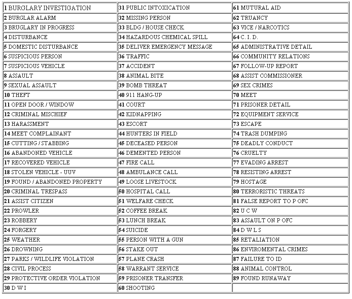
| 20:28, 28 September 2009 | Indiana 10 codes and signals.png (file) |  |
120 KB | Ka3jjz | 1 | |
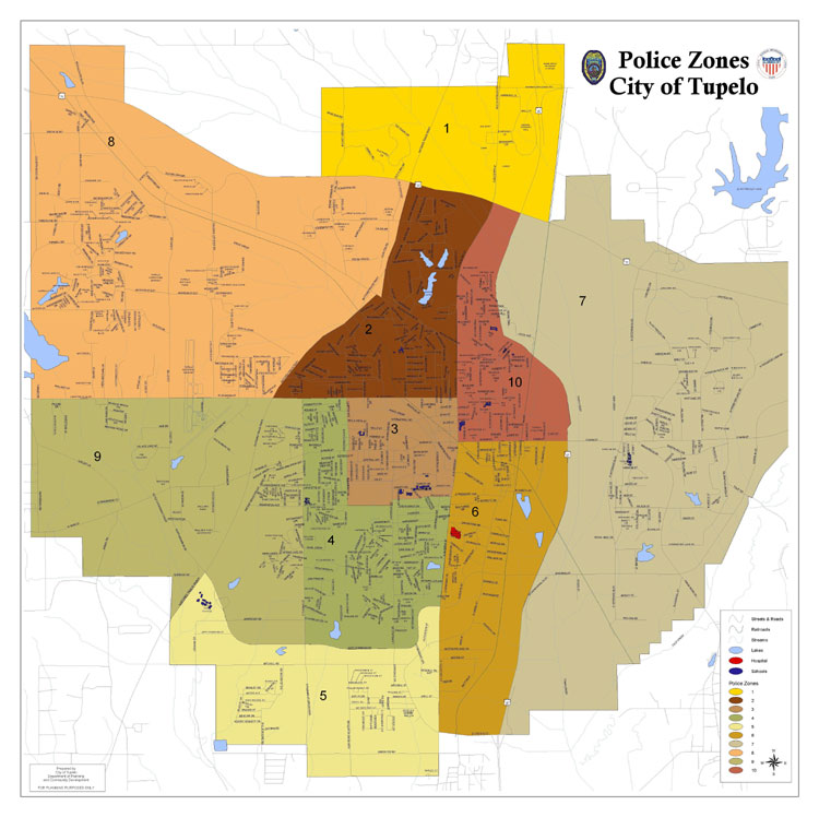
| 18:03, 23 September 2009 | Tupelopdzones.png (file) |  |
611 KB | Milf | Map of the City of Tupelo PD Zones | 1 |
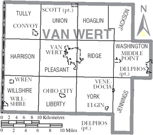
| 12:52, 20 September 2009 | Map of Van Wert County Ohio With Municipal and Township Labels.PNG (file) |  |
61 KB | Radioscan | Map of Van Wert County, Ohio including villages and townships. | 1 |
| 16:14, 8 September 2009 | PS2.png (file) |  |
82 KB | Blantonl | 1 | |
| 16:13, 8 September 2009 | PS1.png (file) |  |
191 KB | Blantonl | 1 | |
| 21:26, 27 August 2009 | Schools.png (file) |  |
2 KB | Ibagli | 1 | |
| 21:26, 27 August 2009 | Police.png (file) |  |
3 KB | Ibagli | 1 | |
| 21:26, 27 August 2009 | Hospitals.png (file) |  |
942 bytes | Ibagli | 1 | |
| 21:26, 27 August 2009 | Firedept.png (file) |  |
3 KB | Ibagli | 1 | |
| 23:20, 26 August 2009 | Collaboration Category Map.png (file) |  |
83 KB | Ibagli | 1 | |
| 21:51, 26 August 2009 | Licking County (OH) Blank.png (file) | 19 KB | Ibagli | 2 | ||
| 00:07, 20 August 2009 | MARCS Map with Roads.png (file) |  |
473 KB | Ibagli | 2 | |
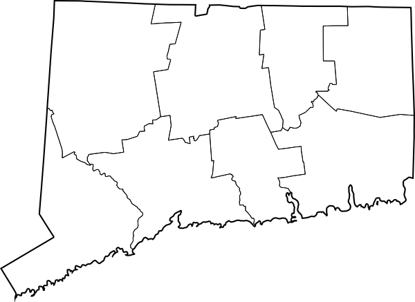
| 02:27, 19 August 2009 | Connecticut County Map Blank.png (file) | 38 KB | Ibagli | 1 | ||
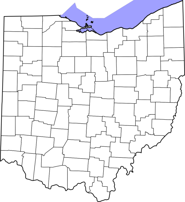
| 03:04, 17 August 2009 | Ohio County Map Blank.png (file) | 92 KB | Ibagli | 1 | ||
| 16:25, 12 August 2009 | USFS R6 Aircraft.png (file) |  |
125 KB | Kd7kdc | Forest Service Region 6 Aircraft Freq by District Map Circa 2009 | 1 |
| 19:19, 15 July 2009 | Zones.png (file) |  |
94 KB | Wa8pyr | Ohio MARCS zones | 1 |
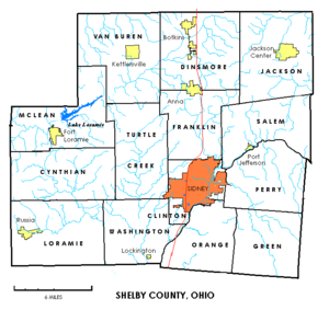
| 12:11, 12 July 2009 | 300px-Shelbytownships.PNG (file) |  |
63 KB | Radioscan | Map of townships in Shelby County, Ohio | 1 |
| 11:07, 12 July 2009 | Map of Marion County Ohio With Municipal and Township Labels.PNG (file) |  |
50 KB | Radioscan | Map of Marion County, Ohio showing municipalities and townships. | 1 |
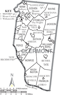
| 08:59, 11 July 2009 | 200px-Map of Clermont County Ohio With Municipal and Township Labels.PNG (file) |  |
68 KB | Radioscan | Map of Clermont County showing Municipalities and Townships | 1 |
| 01:31, 14 June 2009 | Licking County Police.png (file) |  |
194 KB | Ibagli | 1 | |
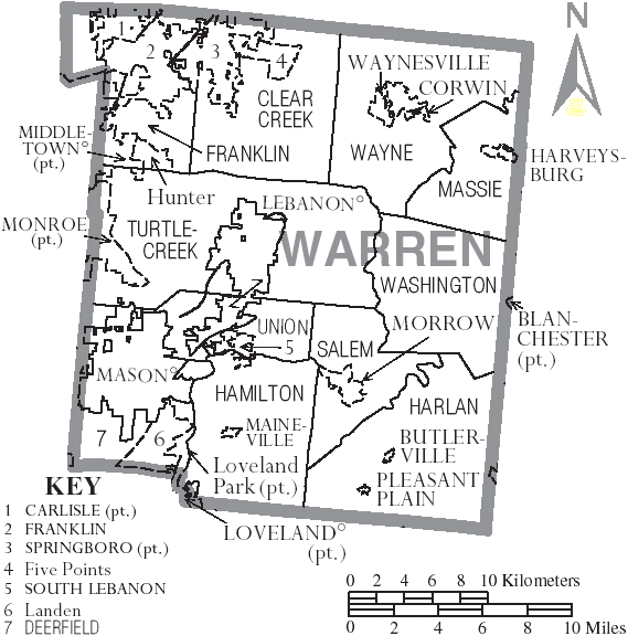
| 22:32, 10 June 2009 | Map of Warren County Ohio With Municipal and Township Labels.PNG (file) |  |
59 KB | Radioscan | 1 | |
| 19:47, 10 June 2009 | Map of Pike County Ohio With Municipal and Township Labels.PNG (file) |  |
38 KB | Radioscan | 1 | |
| 10:54, 10 June 2009 | Map of Butler County Ohio With Municipal and Township Labels.PNG (file) |  |
54 KB | Radioscan | Map of Butler County, Ohio | 1 |
| 10:36, 1 June 2009 | Map of Clinton County Ohio With Municipal and Township Labels.PNG (file) |  |
41 KB | Radioscan | Map of Clinton County, Ohio showing townships and municipalities. | 1 |
| 12:56, 31 May 2009 | Parkregion.png (file) |  |
165 KB | Wa8pyr | Ohio DNR Parks & Recreation regions, showing parks grouped by region | 1 |
| 12:55, 31 May 2009 | Stateregion.png (file) |  |
127 KB | Wa8pyr | Ohio DNR statewide regions showing park locations | 1 |
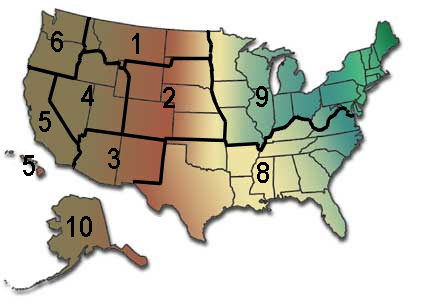
| 06:35, 31 May 2009 | UNITED STATES FOREST SERVICE REGION MAP.png (file) |  |
116 KB | Gvranchosbill | UNITED STATES FOREST SERVICE REGION MAP | 1 |
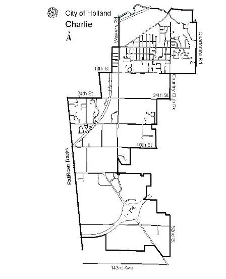
| 13:33, 28 April 2009 | Charlie.png (file) |  |
111 KB | Slash | Zone C (Charlie) | 1 |
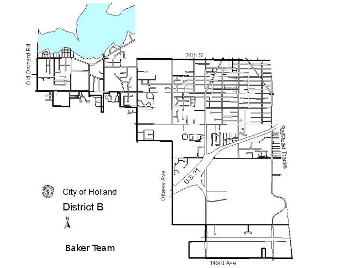
| 13:33, 28 April 2009 | Baker.png (file) |  |
177 KB | Slash | Zone B (Baker) | 1 |
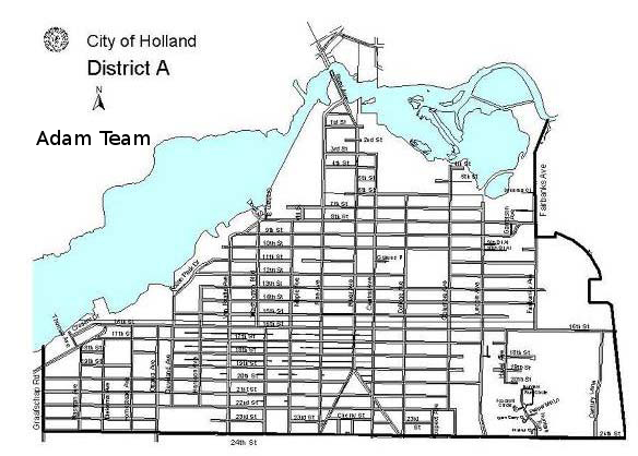
| 13:31, 28 April 2009 | Adam.png (file) |  |
251 KB | Slash | Zone A (Adam) | 1 |
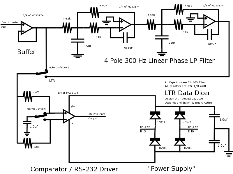
| 20:06, 4 February 2006 | LTRDicer1.png (file) |  |
53 KB | Mikeag | This is a schematic showing modifications necessary to a discriminator output to make it work better when using LTRTrunk and similar LTR utilities | 1 |
_Blank.png)