Railroads (IL)
From The RadioReference Wiki
Revision as of 01:48, 30 October 2016 by N9jig (talk | contribs) (→BNSF (Burlington Northern - Santa Fe))
Revision as of 01:48, 30 October 2016 by N9jig (talk | contribs) (→BNSF (Burlington Northern - Santa Fe))
(This is a work under construction)
Contents
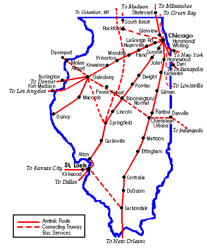
Amtrak
Web Links
- IDOT Railroad Map: http://www.idot.illinois.gov/.../maps.../railroad-maps/il%20railroad%20map%202012.pdf
- KB&S Wiki Page: http://en.wikipedia.org/wiki/Kankakee,_Beaverville_and_Southern_Railroad
Unidentified Hits
MetroEast St. Louis
160.56000  M CSQ  unid - "Crossing the diamond in Girard"  FM  Railroad
161.10000  M CSQ  unid  FM  Railroad
161.45000  M CSQ  unid - Wood River area  FM  Railroad
161.50500  M CSQ  unid  FM  Railroad
Statewide
Amtrak
161.28 heard in use:
- Will County
- Dwight
- Bloomington-Normal
- Detector near Elkhart (Menard)
- Springfield Area
Former use in the Springfield to St Louis Line, but no longer used
BNSF (Burlington Northern - Santa Fe)
161.0100 used for MOW on all former ATSF lines, rarely used on former BN lines.
44.58000 BM BNSF 44.58 unknown use - recently added a lot of BM various locations IL, other states 6/08.