Airports Tulsa County (OK)
From The RadioReference Wiki
Revision as of 12:07, 30 December 2017 by Andy51edge (talk | contribs)
| ICAO: | KRVS |
| FAA: | RVS |
| City: | Tulsa |
| County: | Tulsa |
| State: | Oklahoma |
| TRACON: | Tulsa[ref] |
| ARTCC: | Kansas City |
|
| |
| Database | AirNav |
| Forum | FlightAware |
|
| |
| Aviation FAQ | Aviation Glossary |
|
| |
| Wiki FAQ | MediaWiki |
| QuickRef | PDF Card |
Welcome to the Richard Lloyd Jones Jr Airport (KRVS) aviation article, the airport located in Tulsa County, Oklahoma.
This is where you, the user, may index any articles, frequencies-lists, etc. that you develop for scanning related topics for this airport.
Contents
Airport Information
Richard Lloyd Jones Jr. Airport (IATA: RVS, ICAO: KRVS, FAA LID: RVS) is a city owned, public use airport located five nautical miles (6 mi, 9 km) south of the central business district of Tulsa, a city in Tulsa County, Oklahoma, United States. It is included in the National Plan of Integrated Airport Systems for 2011–2015, which categorized it as a general aviation facility and reliever airport for Tulsa International Airport.
Jones Airport is one of the busiest in the United States. In 2005, it had 347,000 operations, enough to rank it fourth among general aviation (GA) airports and thirtieth among all airports, according to a 2007 FAA report. It also was the busiest in Oklahoma, outranking both Will Rogers World Airport and Tulsa International.
Richard Lloyd Jones Jr Airport Air Traffic Control
| Frequency | License | Type | Tone | Alpha Tag | Description | Mode | Tag |
|---|---|---|---|---|---|---|---|
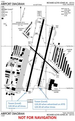
| 120.30000 | KQ9029 | BM | CSQ | Riverside CTAF | Jones (Riverside) CTAF | AM | Aircraft |
| 119.20000 | KQ9029 | BM | CSQ | Riverside Tower | Jones (Riveside) Tower | AM | Aircraft |
| 122.95000 | BM | CSQ | Riverside Uniicm | Jones (Riverside) Unicom | AM | Aircraft | |
| 121.70000 | KQ9029 | BM | CSQ | Riverside Ground | Jones (Riverside) Ground | AM | Aircraft |
| 124.50000 | BM | CSQ | Riverside C/D | Jones (Riverside) Clearance Delivery | AM | Aircraft | |
| 126.50000 | BM | CSQ | Riverside ATIS | Jones (Riverside) ATIS | AM | Aircraft | |
| 134.70000 | BM | CSQ | Riverside Radar | Jones (Riverside) Basic Radar Service | AM | Aircraft |
- The tower's callsign is "Riverside"
- The tower's hours of operation are 7:00am to 10:00pm local time.
- 120.30 is the primary tower frequency active whenever the tower is open, and after the tower closes it becomes the Common Traffic Advisory Frequency (CTAF).
- 119.20 is used as a tower frequency when advertised on ATIS, normally on runway 1R/19L during times of high traffic volume.
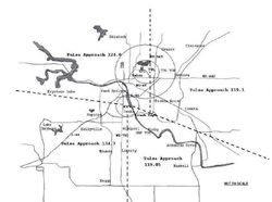
- Radar services and sequencing into the airport are provided by Tulsa Tower's TRACON similar to a class C airport by a letter of agreement between Riverside tower and Tulsa tower.[ref]
- During times of low traffic, for most northbound VFR traffic and most IFR traffic departure radar services are on 124.00. For others it is normally on 134.70.
- For arrivals the approach frequency is normally announced on ATIS. 134.70 is normally used for VFR arrivals. 124.0 is used for IFR arrivals and when volume is low.
Businesses
| Frequency | License | Type | Tone | Alpha Tag | Description | Mode | Tag |
|---|---|---|---|---|---|---|---|
| 130.30000 | WQKP711 | BM | CSQ | Riverside Jet | Jet Center Aircraft Communications | AM | Aircraft |
| 469.55000 | BM | 025 DPL | Riverside Jet | Jet Center Fixed Base Operations | FMN | Business | |
| 129.45000 | KDQ3 | BM | CSQ | ARINC SF RADIO | ARINC San Francisco Radio | AM | Aircraft |
- Riverside Jet Center's lists 130.30 on their website but the license has lapsed and the frequency is no longer listed on airnav.com.
- 469.550 appears to be silent.
- The other FBO on the field is Christiansen Aviation. Their webstie and airnav.com lists 122.95 as being their air to ground frequency.
- Based off of close call capture, 462.3750 DCS465 is believed to be used by Christiansen for handheld radios (Mobile half-duplex). The radio frequency is not licensed and another DMR station is licensed nearby. (WQST822)
Aircraft spotting
There is an outside the fence public viewing area on the southwest side of the airport. The facility has a broadcast FM repeater for the tower and ground control frequencies.[ref]Wikipedia article

