Difference between revisions of "Department of Roads (NE)"
From The RadioReference Wiki
| Line 35: | Line 35: | ||
===Dist 3-Norfolk=== | ===Dist 3-Norfolk=== | ||
| − | + | *Columbus (311) | |
| − | + | *Clarkson (313?) | |
| − | + | *Humphrey-(313?) | |
| − | + | *Bloomfield (322) | |
| − | + | *Plainview (324) | |
| − | + | *Niobrara (325) | |
| − | + | *Norfolk (331) | |
| − | + | *South Sioux City (341) | |
| − | + | *Lyons (342?) | |
| − | + | *Wayne (351) | |
| − | + | *Crofton (352) | |
| − | + | *Hartington (352) | |
| − | + | *Laurel-(353) | |
| − | + | *Newcastle (353) | |
| − | + | *Albion (Unknown) | |
| − | + | *Neligh (Unknown) | |
| − | + | *West Point (Unknown) | |
Revision as of 05:21, 7 February 2021
Contents
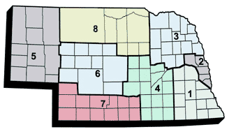
Nebraska Roads Districts
Yard Listings
Dist 1-Lincoln
- Lincoln – 302 Superior St. (111)
- Seward (112)
- David City (113)
- Wahoo (114)
- Greenwood (115)
- Dorchester (122)
- Beatrice (124)
- Lincoln – 5300 Salt Valley View St. (125)
- Palmyra (131)
- Nebraska City (132)
- Tecumseh (133)
- Auburn (134)
- Pawnee City (135?)
- Fairbury (unknown)
- Falls City (Unknown)
Dist 2-Omaha
- Omaha 108 (211)
- Omaha Morman Bridge (212)
- Omaha South (213)
- Blair (221)
- Fremont (222)
- Elkhorn (232)
- Gretna (234)
- Platmouth (236)
Dist 3-Norfolk
- Columbus (311)
- Clarkson (313?)
- Humphrey-(313?)
- Bloomfield (322)
- Plainview (324)
- Niobrara (325)
- Norfolk (331)
- South Sioux City (341)
- Lyons (342?)
- Wayne (351)
- Crofton (352)
- Hartington (352)
- Laurel-(353)
- Newcastle (353)
- Albion (Unknown)
- Neligh (Unknown)
- West Point (Unknown)
