Ohio MARCS - Multi-Agency Radio Communications
From The RadioReference Wiki
About
The Ohio Multi-Agency Radio Communications System (MARCS) is a Motorola Type II SmartZone/Omnilink system with 100% digital audio.
Most state agencies use this system to some extent, with agencies like the Highway Patrol, Department of Natural Resources, Emergency Management and other emergency services using the system almost exclusively.
Various local agencies also use the system; please check the database for a complete listing of talkgroups.
Monitoring MARCS
The following scanners can be used to track the system:
- GRE: PSR-500, PSR-600
- Radio Shack: PRO-106, PRO-197, PRO-96 and PRO-2096
- Uniden: BC250D, BC785D, BC296D, BC796D, BCD396T, BCD396XT, BCD996T and BCD996XT
Unconfirmed Sites
19x CELINA (MERCER)
+40° 33' 10.50", -84° 31' 2.10"
40.552917, -84.517250
CALLSIGN:  WQKH688
ALIAS:
TWR REG #: 1266029
TWR OWNER:  STATE OF OHIO
1300 FT WEST OF DIBBLE RD
N OF SR703 BY RR TRACKS
CELINA, OHIO
MERCER COUNTY

NOTE: Construction completed 3-18-09.   Randy has pictures!
1xx VAN WERT (VAN WERT)
+40° 52' 42.60", -84° 34' 40.00"
40.878500, -84.577778
WQGR446
ALIAS:
N CHERRY ST INT WITH GLEASON ST
VAN WERT, OHIO
VAN WERT COUNTY
293 FINDLAY (HANCOCK)
+41° 4' 42.00", -83° 38' 53.00"
41.078333, -83.648056
TWR REG: 1015615
TWR OWNER:  STATE OF OHIO
LICENSES:
WQKL660 - TRUNKED FREQS
MARCS SID:
SITE ALIAS:
3201 N MAIN ST
FINDLAY, OHIO
HANCOCK COUNTY

NOTE:  According to a PDF attachment submitted along with the FCC application
0003885320 (which was subsequently issued WQKL660 callsign), There will be two voice
freqs licensed by the State of Ohio - Plus, four frequencies from the Findlay City
Services license (WPKV206) will also be used on this site.   Sounds like some new
users are planned in Hancock Co.
2XX HOLGATE (HENRY)
+41° 18' 12.50", -84° 12' 36.50"
41.303472,-84.210139
TWR REG #: 1234396
TWR OWNER: STATE OF OH DAS
LICENSES:
MARCS SID: 2XX
J530 COUNTY RD 18
FLORIDA, OHIO
HENRY COUNTY
2XX EAST SPARTA (STARK)
+40° 39' 43.80", -81° 22' 13.60"
40.662167,-81.370444
TWR REG #: 1240800
TWR OWNER: STATE OF OH DAS
LICENSES:
MARCS SID:
9916 RIDGE AVENUE SOUTH
EAST SPARTA, OH
STARK COUNTY
3xx HILLSBORO (HIGHLAND)
+39° 15' 14.00", -83° 36' 30.00"
39.253889, -83.608333
WQJJ355
3 MI N
HILLSBORO, OHIO
HIGHLAND COUNTY
3xx WASHINGTON CH (FAYETTE)
+39° 31' 3.50", -83° 25' 4.30"
39.517639, -83.417861
WQJJ355
1584 CREEK RD, S.E.
WASHINGTON COURTHOUSE, OHIO
FAYETTE COUNTY
xxx PORT WASHINGTON (TUSCARAWAS)
+40° 14' 47.00", -81° 26' 10.00"
40.246389, -81.436111
TWR REG #: 1244824
TWR OWNER: OHIO, STATE OF
LICENSES
WQKJ265 - TRUNKED FREQS
867.8625
868.4250
(possibly related to Site 445 GILMORE)
MARCS SID:
SITE ALIAS:
15829 Gilmore Road SE
PORT WASHINGTON, OHIO
TUSCARAWAS COUNTY
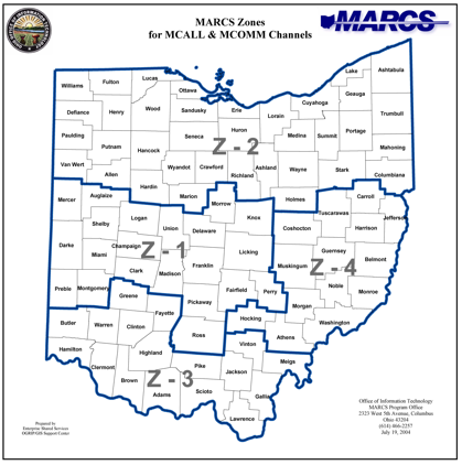
System Zones
At one point the zone map below may have been accurate, but in recent areas there has been quite a bit of movement of sites out of one zone and into another. This map is not 100% accurate but is the best we have available.
Related Links
- Ohio MARCS Yahoo Group - Group Discussion of the Ohio Multi-Agency Radio Communications System
- Ohio MARCS Homepage - Ohio DAS / OIT MARCS Homepage
- Ohio MARCS Newsletter - Ohio MARCS Newsletters
