Difference between revisions of "Ohio MARCS - Multi-Agency Radio Communications"
From The RadioReference Wiki
| Line 48: | Line 48: | ||
* 6F10-038 Kirkwood (853.05000c) | * 6F10-038 Kirkwood (853.05000c) | ||
* 6F10-040 Kensington (853.90000c) | * 6F10-040 Kensington (853.90000c) | ||
| + | * 6F10-049 Deersville (852.78750a 853.17500d 860.43750) | ||
* 6F10-050 Germano (852.10000a 852.37500c) | * 6F10-050 Germano (852.10000a 852.37500c) | ||
* 6F10-051 New Alexandria (852.18750a 852.82500c 856.46250) | * 6F10-051 New Alexandria (852.18750a 852.82500c 856.46250) | ||
Revision as of 14:15, 1 May 2016
| System Name | State of Ohio MARCS - Multi-Agency Radio Communications |
| System Type | Motorola Type II SmartZone OmniLink w/Project 25 |
| System ID | 6F0F, 6F10, 6F16, 712D, 9112 |
| Connect Tone | 83.72, 97.30, 90.00, 128.57 |
| Wide Area Communications Network | ? |
| Network Access Code | ? |
| TRBO Color Code | ? |
| NXDN RAN | |
| Band | 800 |
| County | Various |
| State | Ohio |
| Ownership | Public |
|
| |
| State of Ohio MARCS - Multi-Agency Radio Communications RR DB Entry | |
| State of Ohio MARCS - Multi-Agency Radio Communications Site Map from the RRDB | |
| Ohio Discussion Forum | |
|
| |
| MediaWiki | |
| QuickRef | |
| PDF Card | |
Welcome to the State of Ohio MARCS - Multi-Agency Radio Communications collaboration article, a Trunked Radio System located in Ohio.
This is where you, the user, may index any articles you develop for scanning related topics for this Trunked Radio System.
Contents
About
The Ohio Multi-Agency Radio Communications System (MARCS) is a Motorola Type II SmartZone/Omnilink system with 100% digital audio.
Most state agencies use this system to some extent, with agencies like the Highway Patrol, Department of Natural Resources, Emergency Management and other emergency services using the system almost exclusively.
Various local agencies also use the system; please check the database for a complete listing of talkgroups.
See the Ohio Counties page in the Wiki or the Ohio State Agencies page for additional information on system subscribers.
Monitoring MARCS
The following scanners can be used to track the system:
- GRE: PSR-500, PSR-600, PSR-800
- Radio Shack: PRO-106, PRO-197, PRO-96, PRO-2096, PRO-651, and PRO-652
- Uniden: BC250D, BC785D, BC296D, BC796D, BCD396T, BCD396XT, BCD996T, BCD996XT, HomePatrol-1, BCD436HP, and BCD536HP
- Whistler: WS1040, WS1065, WS1080
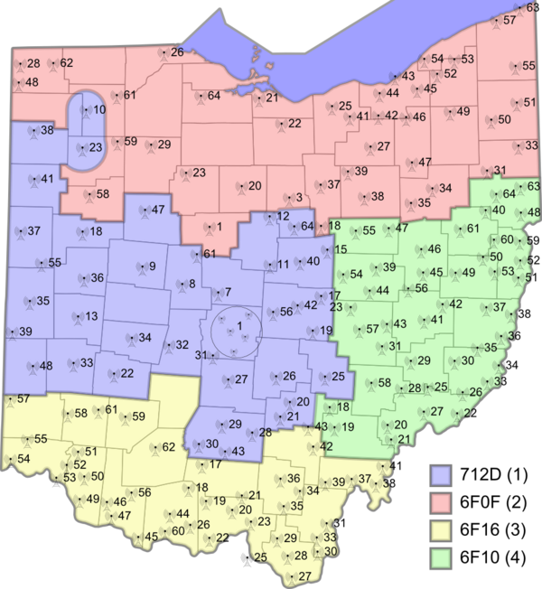
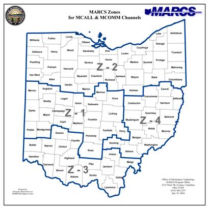
Map of system sites and zones
Current MARCS Zones (10-21-2009)
MARCS Zone Map (pre-2009)
Decommissioned Sites
- 6F0F-001 Marion (851.72500 851.77500 852.31250a 852.57500d 854.53750 858.18750)
- 6F10-023 Dresden (852.86250a 853.38750c)
- 6F10-031 Duncan Falls (853.12500a 853.60000c)
- 6F10-038 Kirkwood (853.05000c)
- 6F10-040 Kensington (853.90000c)
- 6F10-049 Deersville (852.78750a 853.17500d 860.43750)
- 6F10-050 Germano (852.10000a 852.37500c)
- 6F10-051 New Alexandria (852.18750a 852.82500c 856.46250)
- 6F10-052 Mingo (851.82500 853.95000c)
- 6F10-057 Zanesville (853.4375)
- 6F10-059 Stratton (852.12500c)
- 712D-008 Marysville (852.73750 853.62500a 853.91250c)
- 712D-017 St Louisville (851.36250 851.85000a 851.98750 852.95000c 856.08750)
- 712D-018 Wapakoneta (851.93750 852.53750a 853.22500d)
- 712D-019 Linnville (851.58750a 852.10000c 856.46250 856.73750 857.03750)
- 712D-035 Greenville (852.70000a 853.17500d 856.93750 857.93750)
- 712D-036 Sidney (851.65000 852.60000a 853.12500a 853.78750d)
- 712D-056 Alexandria (851.97500 852.70000c 852.91250 853.23750a 853.70000 854.98750)
- 712D-061 Richwood (852.11250a 852.96250c)
Related Links
- Ohio MARCS Yahoo Group - Group Discussion of the Ohio Multi-Agency Radio Communications System
- Ohio DAS / OIT MARCS Homepage
- Ohio MARCS Task Force Report - Ohio MARCS Task Force Report
- Zone 1 Google Map - Zone 1 Google Map
- Zone 2 Google Map - Zone 2 Google Map
- Zone 3 Google Map - Zone 3 Google Map
- Zone 4 Google Map - Zone 4 Google Map

