Difference between revisions of "Cook County (MN)"
From The RadioReference Wiki
| Line 1: | Line 1: | ||
| − | {{ | + | {{Minnesota Infobox |
| − | | | + | |County = Cook |
| − | | | + | |FIPS County Number = 031 |
| − | | | + | |County Seat = Grand Marais |
| + | |MSP District = 2750 | ||
| + | |MSP HQ City = Duluth | ||
| + | |MSP CVI = 4750 | ||
| + | |Mn/DOT District = 1 | ||
| + | |DNR District = 6 | ||
| + | |ARMER Region = 5 | ||
| + | |EMS Region = Northeast | ||
| + | |FBI HQ = Minneapolis | ||
| + | |FBI RA = Duluth | ||
| + | |ctid = 1325 | ||
| + | }} | ||
==Law Enforcement Agencies== | ==Law Enforcement Agencies== | ||
*Cook County Sheriffs Office | *Cook County Sheriffs Office | ||
| + | **[http://www.co.cook.mn.us/index.php/government/departments/sheriff Cook County Sheriffs Office Website] | ||
==Fire Departments== | ==Fire Departments== | ||
| Line 11: | Line 23: | ||
*Gunflint Lake Fire | *Gunflint Lake Fire | ||
*Gunflint Trail Fire | *Gunflint Trail Fire | ||
| + | **[www.gunflint911.org Gunflint Trail Fire & EMS Website] | ||
*Schroeder Fire | *Schroeder Fire | ||
*Tofte Fire | *Tofte Fire | ||
*Lutsen Twsp. Fire | *Lutsen Twsp. Fire | ||
*Superior National Forest Fire | *Superior National Forest Fire | ||
| + | **[http://www.fs.usda.gov/wps/portal/fsinternet/!ut/p/c4/04_SB8K8xLLM9MSSzPy8xBz9CP0os3gjAwhwtDDw9_AI8zPyhQoY6BdkOyoCAGixyPg!/?ss=110909&navtype=BROWSEBYSUBJECT&cid=FSM91_049815&navid=130120000000000&pnavid=130000000000000&position=Feature*&ttype=detail&pname=Superior%20National%20Forest-%20Resource%20Management Superior National Forest Fire & Aviation Webpage] | ||
*Maple Hill Fire | *Maple Hill Fire | ||
*Grand Marais Fire | *Grand Marais Fire | ||
| Line 26: | Line 40: | ||
*Cook County Ambulance (BLS) | *Cook County Ambulance (BLS) | ||
*Gunflint Trail Fire Department (BLS) | *Gunflint Trail Fire Department (BLS) | ||
| + | **[www.gunflint911.org Gunflint Trail Fire & EMS Website] | ||
*Grand Portage Ambulance (BLS) | *Grand Portage Ambulance (BLS) | ||
| + | |||
| + | ==Trunked Radio Systems== | ||
| + | *[[Allied Radio Matrix for Emergency Response (ARMER)]] - 800 MHz [[Project 25]] Phase I | ||
| + | *[[Great River Energy]] - UHF [[Motorola Type II SmartZone OmniLink]] | ||
==ARMER Migration== | ==ARMER Migration== | ||
[[Image:CookMNARMER.jpg]] | [[Image:CookMNARMER.jpg]] | ||
| − | *Status - | + | *Status - Planning Migration to [[Allied Radio Matrix for Emergency Response (ARMER)|ARMER]] |
*Sites and Status: | *Sites and Status: | ||
{|class=toccolours border=1 style=border-collapse:collapse cellpadding=3 | {|class=toccolours border=1 style=border-collapse:collapse cellpadding=3 | ||
!Site ID!!Site Name!!Status!!Lat.!!Long. | !Site ID!!Site Name!!Status!!Lat.!!Long. | ||
|- | |- | ||
| − | |5-040||Mount Maud||[[Image:ARMEROA.jpg]]|| || | + | |5-040-01||Maple Hill||[[Image:ARMEROA.jpg]]|| || |
| + | |- | ||
| + | |5-040-02||Bogus Lake||[[Image:ARMEROA.jpg]]|| || | ||
| + | |- | ||
| + | |5-040-03||Mount Maud||[[Image:ARMEROA.jpg]]|| || | ||
|- | |- | ||
| − | |5-040||Devil Fish | + | |5-040-04||Devil Fish Lookout||[[Image:ARMERP.jpg]]|| || |
|- | |- | ||
| − | |5-040|| | + | |5-040-05||Pine Mountain||[[Image::ARMERIER.jpg]]|| || |
|- | |- | ||
| − | |5-040|| | + | |5-040-06||Gun Flint||[[Image:ARMERP.jpg]]|| || |
|- | |- | ||
| − | |5- | + | |5-040-07||Cascade Lake||[[Image:ARMERS.jpg]]|| || |
|- | |- | ||
| − | |5- | + | |5-040-08||Lima Mountain||[[Image:ARMERP.jpg]]|| || |
|- | |- | ||
| − | |5- | + | |5-040-09||Sawbill Trail North Tofte||[[Image:ARMERS.jpg]]|| || |
|- | |- | ||
| − | |5- | + | |5-040-10||Hovland Lookout||[[Image::ARMERIER.jpg]]|| || |
| + | |- | ||
| + | |5-040-11||Mid Trail||[[Image::ARMERIER.jpg]]|| || | ||
| + | |- | ||
| + | |5-042-01||Honeymoon||[[Image:ARMEROA.jpg]]|| || | ||
| + | |- | ||
| + | |5-042-02||Lutsen||[[Image:ARMEROA.jpg]]|| || | ||
| + | |} | ||
| + | |||
| + | ==Recommended Scanning== | ||
| + | ===VHF=== | ||
| + | {|class=toccolours border=1 style=border-collapse:collapse cellpadding=3 | ||
| + | !Frequency!!Tone!!Usage | ||
|- | |- | ||
| − | | | + | |155.7900||167.9 PL||Cook County Sheriff Dispatch |
|- | |- | ||
| − | | | + | |158.7300||743 DPL||Cook County Sheriff Dispatch |
|- | |- | ||
| − | | | + | |155.9250||CSQ||Cook County Fire/EMS Dispatch |
| + | |} | ||
| + | |||
| + | ===ARMER=== | ||
| + | {|class=toccolours border=1 style=border-collapse:collapse cellpadding=3 | ||
| + | !TGID!!Usage | ||
|- | |- | ||
| − | | | + | |36500||State Patrol Duluth |
|} | |} | ||
| + | |||
| + | {{Geographic location | ||
| + | |Center = Cook County, Minnesota | ||
| + | |North = [[Thunder Bay County (ON)|Thunder Bay District]], [[Ontario (CA)|Ontario]], Canada | ||
| + | |Northeast = | ||
| + | |East = [[Keweenaw County (MI)|Keweenaw County]], [[Michigan (US)|Michigan]] | ||
| + | |Southeast = [[Ontonagon County (MI)|Ontonagon County]], [[Michigan (US)|Michigan]] | ||
| + | |South = | ||
| + | |Southwest = | ||
| + | |West = [[Lake County (MN)|Lake County]], [[Minnesota (US)|Minnesota]] | ||
| + | |Northwest = [[Rainy River County (ON)|Rainy River District]], [[Ontario (CA)|Ontario]], Canada | ||
| + | }} | ||
| + | |||
| + | Return to [[Minnesota (US)|Minnesota]] | ||
[[Category:Midwest Region]] | [[Category:Midwest Region]] | ||
Revision as of 12:51, 13 June 2011
Contents
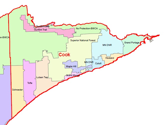
Law Enforcement Agencies
- Cook County Sheriffs Office
Fire Departments
- Gunflint Lake Fire
- Gunflint Trail Fire
- [www.gunflint911.org Gunflint Trail Fire & EMS Website]
- Schroeder Fire
- Tofte Fire
- Lutsen Twsp. Fire
- Superior National Forest Fire
- Maple Hill Fire
- Grand Marais Fire
- Minnesota DNR Fire
- Colvill Fire
- Hovland Fire
- Grand Portage Fire
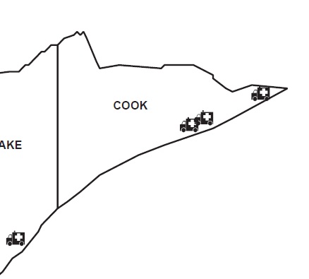
Emergency Medical Services
- Cook County Ambulance (BLS)
- Gunflint Trail Fire Department (BLS)
- [www.gunflint911.org Gunflint Trail Fire & EMS Website]
- Grand Portage Ambulance (BLS)
Trunked Radio Systems
- Allied Radio Matrix for Emergency Response (ARMER) - 800 MHz Project 25 Phase I
- Great River Energy - UHF Motorola Type II SmartZone OmniLink
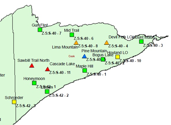
ARMER Migration
- Status - Planning Migration to ARMER
- Sites and Status:
Recommended Scanning
VHF
| Frequency | Tone | Usage |
|---|---|---|
| 155.7900 | 167.9 PL | Cook County Sheriff Dispatch |
| 158.7300 | 743 DPL | Cook County Sheriff Dispatch |
| 155.9250 | CSQ | Cook County Fire/EMS Dispatch |
ARMER
| TGID | Usage |
|---|---|
| 36500 | State Patrol Duluth |
Return to Minnesota


