|
|
| (5 intermediate revisions by 2 users not shown) |
| Line 1: |
Line 1: |
| | + | {{Infobox_TRS_MultiState |
| | + | |SysName = Indiana Project Hoosier SAFE-T (P25) |
| | + | |Flavor = [[Project 25]] Phase 1 |
| | + | |SysID = 6BD |
| | + | |WACN = BEE00 |
| | + | |CTone = ? |
| | + | |CCode = ? |
| | + | |NAC = ? |
| | + | |Band = 800 |
| | + | |State = [[Indiana (US)|IN]], [[Kentucky (US)|KY]] |
| | + | |OwnerTy = Public |
| | + | |sid = 8084 |
| | + | }} |
| | | | |
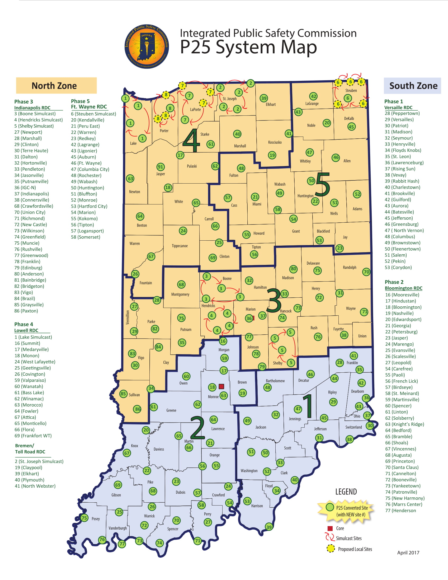
| − | ==Rebanding Info== | + | ==System Map== |
| − | The Indiana Project Hoosier SAFE-T system completed rebanding on 11-16-12.
| + | [https://www.in.gov/ipsc/images/System_Map_Feb_2020.pdf IPSC P25 System Map] |
| | + | -Removed by the state for Security Reasons |
| | | | |
| − | ==SAFE-T System Map==
| + | Motorola Provides a map on their [https://www.motorolasolutions.com/en_us/states/indiana.html#maps "system advertisement page"]. Unsure how up-to-date this is. |
| | + | [https://www.motorolasolutions.com/content/dam/msi/images/states/indianasafet/april_2017_statewide_map.jpg Motorola IPSC Map] |
| | | | |
| | + | ==Related Pages== |
| | + | * [[Indiana Project Hoosier SAFE-T (P25) RID]] |
| | + | * [[Indiana Project Hoosier SAFE-T (P25) System Information]] |
| | | | |
| − | ==SAFE-T Mutual Aid Areas==
| + | [[Category:Indiana Trunked Radio Systems]] |
| − | This list contains old ISP district numbers. While some of these are no longer utilized, the regional MA talkgroups still conform to these old district boundaries.<BR><BR>
| + | [[Category:Kentucky Trunked Radio Systems]] |
| − | | + | [[Category:Statewide Public Safety Systems]] |
| − | [[File:SAFE-T Regional Mutual Aid Map.jpg|200px|thumb|left|SAFE-T Mutual Aid Map]] | |
| − | | |
| − | {| border="4" cellpadding="4" cellspacing="0" style="margin: 1em 1em 1em 0; background: #f9f9f9; border: 2px #777777 solid; border-collapse: collapse;" class="wikitable sortable"
| |
| − | |Region||District||Counties
| |
| − | |-
| |
| − | |A ||13 (Lowell Area) ||Lake, Porter, Laporte, Newton, Jasper, Starke, Pulaski
| |
| − | |-
| |
| − | |B ||24 (Bremen Area) ||St. Joseph, Elkhart, Marshall, Kosciusko
| |
| − | |-
| |
| − | |C ||22 (Fort Wayne) ||Lagrange, Steuben, Noble, Dekalb, Whitley, Allen, Huntington, Wells, Adams
| |
| − | |-
| |
| − | |D ||14 (Lafayette) ||Benton, White, Carroll, Warren, Tippecanoe, Clinton, Fountain, Montgomery
| |
| − | |-
| |
| − | |E ||16 (Peru) ||Fulton, Cass, Miami, Wabash, Howard, Tipton
| |
| − | |-
| |
| − | |F ||25 (Redkey) ||Grant, Blackford, Jay, Delaware, Randolph
| |
| − | |-
| |
| − | |G ||51 (Pendleton) ||Hamilton, Madison, Hancock
| |
| − | |-
| |
| − | |H ||54 (Terre Haute) ||Clay, Sullivan, Parke, Vermillion, Vigo
| |
| − | |-
| |
| − | |I ||53 (Putnamville) ||Putnam, Hendricks, Morgan
| |
| − | |-
| |
| − | |J ||52 (Indianapolis) ||Boone, Hendricks, Marion, Johnson, Shelby
| |
| − | |-
| |
| − | |K ||41 (Connersville) ||Henry, Rush, Wayne, Fayette, Union, Franklin
| |
| − | |-
| |
| − | |L ||33 (Bloomington) ||Owen, Greene, Monroe, Morgan, Brown, Lawrence
| |
| − | |-
| |
| − | |M ||43 (Seymour) ||Jackson, Bartholomew, Jennings
| |
| − | |-
| |
| − | |N ||42 (Versailles) ||Decatur, Ripley, Dearborn, Ohio, Jefferson, Switzerland
| |
| − | |-
| |
| − | |O ||35 (Evansville) ||Knox, Gibson, Pike, Posey, Vanderburgh, Warrick
| |
| − | |-
| |
| − | |P ||34 (Jasper) ||Daviess, Martin, Orange, Dubois, Crawford, Perry, Spencer
| |
| − | |-
| |
| − | |Q ||45 (Sellerburg) ||Washington, Scott, Clark, Floyd, Harrison
| |
| − | |}
| |
| − | | |
| − | ==Site NAC Codes==
| |
| − | *All tower sites in the database have corresponding NAC codes under their individual listing.
| |
| − | | |
| − | ==Related Links==
| |
| − | * [http://ftp2.census.gov/geo/maps/general_ref/cousub_outline/cen2k_pgsz/in_cosub.pdf County/Township map (PDF)]
| |
| − | * [http://www.in.gov/indot/3184.htm Indiana DOT districts]
| |
| − | * [http://www.in.gov/ipsc/ Indiana SAFE-T page]
| |
| − | * [[Project Hoosier SAFE-T Conventional Interoperability (IN)]]
| |
| − | * [[Indiana State Police (IN)]]
| |
| − | | |
| − | [[Category:Indiana Deprecated Trunked Systems]] | |
| − | | |
| − | | |
| − | ==SAFE-T Mutual Aid Areas==
| |
| − | This list contains old ISP district numbers. While some of these are no longer utilized, the regional MA talkgroups still conform to these old district boundaries.<BR><BR>
| |
| − | | |
| − | [[File:SAFE-T Regional Mutual Aid Map.jpg|200px|thumb|left|SAFE-T Mutual Aid Map]]
| |
| − | | |
| − | {| border="4" cellpadding="4" cellspacing="0" style="margin: 1em 1em 1em 0; background: #f9f9f9; border: 2px #777777 solid; border-collapse: collapse;" class="wikitable sortable"
| |
| − | |Region||District||Counties
| |
| − | |-
| |
| − | |A ||13 (Lowell Area) ||Lake, Porter, Laporte, Newton, Jasper, Starke, Pulaski
| |
| − | |-
| |
| − | |B ||24 (Bremen Area) ||St. Joseph, Elkhart, Marshall, Kosciusko
| |
| − | |-
| |
| − | |C ||22 (Fort Wayne) ||Lagrange, Steuben, Noble, Dekalb, Whitley, Allen, Huntington, Wells, Adams
| |
| − | |-
| |
| − | |D ||14 (Lafayette) ||Benton, White, Carroll, Warren, Tippecanoe, Clinton, Fountain, Montgomery
| |
| − | |-
| |
| − | |E ||16 (Peru) ||Fulton, Cass, Miami, Wabash, Howard, Tipton
| |
| − | |-
| |
| − | |F ||25 (Redkey) ||Grant, Blackford, Jay, Delaware, Randolph
| |
| − | |-
| |
| − | |G ||51 (Pendleton) ||Hamilton, Madison, Hancock
| |
| − | |-
| |
| − | |H ||54 (Terre Haute) ||Clay, Sullivan, Parke, Vermillion, Vigo
| |
| − | |-
| |
| − | |I ||53 (Putnamville) ||Putnam, Hendricks, Morgan
| |
| − | |-
| |
| − | |J ||52 (Indianapolis) ||Boone, Hendricks, Marion, Johnson, Shelby
| |
| − | |-
| |
| − | |K ||41 (Connersville) ||Henry, Rush, Wayne, Fayette, Union, Franklin
| |
| − | |-
| |
| − | |L ||33 (Bloomington) ||Owen, Greene, Monroe, Morgan, Brown, Lawrence
| |
| − | |-
| |
| − | |M ||43 (Seymour) ||Jackson, Bartholomew, Jennings
| |
| − | |-
| |
| − | |N ||42 (Versailles) ||Decatur, Ripley, Dearborn, Ohio, Jefferson, Switzerland
| |
| − | |-
| |
| − | |O ||35 (Evansville) ||Knox, Gibson, Pike, Posey, Vanderburgh, Warrick
| |
| − | |-
| |
| − | |P ||34 (Jasper) ||Daviess, Martin, Orange, Dubois, Crawford, Perry, Spencer
| |
| − | |-
| |
| − | |Q ||45 (Sellerburg) ||Washington, Scott, Clark, Floyd, Harrison
| |
| − | |}
| |
| − | | |
| − | ==Site NAC Codes==
| |
| − | *All tower sites in the database have corresponding NAC codes under their individual listing.
| |
| − | | |
| − | ==Related Links==
| |
| − | * [http://ftp2.census.gov/geo/maps/general_ref/cousub_outline/cen2k_pgsz/in_cosub.pdf County/Township map (PDF)]
| |
| − | * [http://www.in.gov/indot/3184.htm Indiana DOT districts]
| |
| − | * [http://www.in.gov/ipsc/ Indiana SAFE-T page]
| |
| − | * [[Project Hoosier SAFE-T Conventional Interoperability (IN)]]
| |
| − | * [[Indiana State Police (IN)]]
| |
| − | | |
| − | [[Category:Indiana Deprecated Trunked Systems]] | |
| − | | |
| − | | |
| − | https://www.in.gov/ipsc/images/System_Map_Feb_2020.pdf
| |