Difference between revisions of "Individual CO DTRS Sites/Smokey Hill"
From The RadioReference Wiki
m (updated Refreshpage link) |
|||
| Line 9: | Line 9: | ||
|OthNotes=None}} | |OthNotes=None}} | ||
| − | |||
| − | |||
| − | |||
===Approximate Coverage Map=== | ===Approximate Coverage Map=== | ||
| Line 20: | Line 17: | ||
[[Individual CO DTRS Sites|Back to Colorado DTRS site list]] | [[Individual CO DTRS Sites|Back to Colorado DTRS site list]] | ||
| + | |||
| + | |||
| + | |||
| + | |||
| + | |||
| + | |||
| + | |||
| + | {{Refreshpage}} | ||
[[Category: Colorado DTRS Site Information]] | [[Category: Colorado DTRS Site Information]] | ||
Latest revision as of 16:20, 10 November 2015
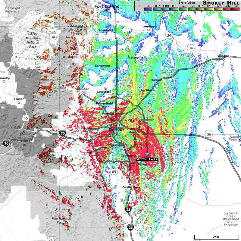
Smokey Hill (1-007)
- Frequencies:
| Site | Name | Freqs | |||||||
|---|---|---|---|---|---|---|---|---|---|
| 007 (7) | Smoky Hill | 769.581250 | 770.856250 | 771.856250 | 772.756250 | 773.668750 | 851.112500 | 851.450000 | 851.737500 |
| 852.150000 | 852.287500 | 852.475000 | 852.712500 | 853.175000 | 853.400000c | 853.625000c | 853.875000c | ||
| 854.687500 | 857.512500 |
- County Location: Arapahoe
- Counties Covered: Arapahoe, Denver
- Agencies Frequently Affiliating: ?
- Denied Affiliations: City of Thornton, El Paso County, some Adams County talk groups (non public service except schools).
- Other Notes: None
- Please click on the site name (in blue) in the database listing for more information
Approximate Coverage Map

[Click here for full resolution]
Back to Colorado DTRS site list
Refresh this page from the latest database entry