Difference between revisions of "Toronto County (ON)"
From The RadioReference Wiki
| Line 54: | Line 54: | ||
[http://maps.google.com/maps/ms?ie=UTF8&hl=en&msa=0&ll=43.739848,-79.341888&spn=0.305095,0.727158&t=h&z=11&msid=114001052992410372968.000492fe72310420312b9 Google Map of Toronto Fire Service Stations] | [http://maps.google.com/maps/ms?ie=UTF8&hl=en&msa=0&ll=43.739848,-79.341888&spn=0.305095,0.727158&t=h&z=11&msid=114001052992410372968.000492fe72310420312b9 Google Map of Toronto Fire Service Stations] | ||
| − | ===Active | + | ===Active Incidents Link=== |
[http://www.toronto.ca/fire/cadinfo/livecad.htm Live CAD] | [http://www.toronto.ca/fire/cadinfo/livecad.htm Live CAD] | ||
Revision as of 13:57, 22 November 2013
Contents
Toronto Public Safety
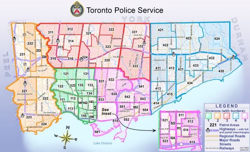
Toronto Police Service Divisional Map with Patrol Areas
Google Maps for TPS Stations
Google Maps Toronto Police Divisions
Toronto Emergency Medical Services (EMS)
![]()
Communications
The Toronto EMS communications systems makes use of the Toronto Public Safety System, which is also used by The Toronto Police Service and The Toronto Fire Service.
Additional information on the Toronto EMS Communications and Dispatch may be found on the Toronto EMS Website in the Communication Section, or on the Toronto Public Safety wiki page
Google Maps Station Locations
Toronto Fire Service
Fire Operations

North,East,South,West Quadrant Channel line up
- 1 - Operations (talkgroup)
- 2 - Tactical 1 (talkgroup)
- 3 - Talkaround 1 (conventional)
- 4 - Tactical 2 (talkgroup)
- 5 - Talkaround 2 (conventional)
- 6 - Tactical 3 (talkgroup)
- 7 - Talkaround 3 (conventional)
- 8 - Tactical 4 (talkgroup)
- 9 - Talkaround 4 (conventional)
- 10-Tactical 5 (talkgroup)
- 11-Talkaround 5 (conventional)
- 12-Tactical 6 (talkgroup)
- 13-Talkaround 6 (conventional)
- 14-Strategic 1 (talkgroup)
- 15-Strategic 2 (talkgroup)
- 16-Prevention (talkgroup)
Google Map of Stations
Google Map of Toronto Fire Service Stations
Active Incidents Link
(updated at five minute intervals)