Tulsa International Airport (TUL) Tulsa County (OK)
From The RadioReference Wiki
Revision as of 16:55, 28 December 2017 by Andy51edge (talk | contribs)
Revision as of 16:55, 28 December 2017 by Andy51edge (talk | contribs)
| ICAO: | KTUL |
| FAA: | TUL |
| City: | Tulsa |
| County: | Tulsa |
| State: | Oklahoma |
| TRACON: | ? |
| ARTCC: | Kansas City |
|
| |
| Database | AirNav |
| Forum | FlightAware |
|
| |
| Aviation FAQ | Aviation Glossary |
|
| |
| Wiki FAQ | MediaWiki |
| QuickRef | PDF Card |
Welcome to the Tulsa International Airport (TUL) aviation article, the airport located in Tulsa County, Oklahoma.
This is where you, the user, may index any articles, frequencies-lists, etc. that you develop for scanning related topics for this airport.
Tulsa International Airport (KTUL) Air Traffic Control
| VHF Frequency | UHF Frequency | Area of Control | Callsign |
|---|---|---|---|
| 118.70 | 257.80 | Runway 36L/18R | Tulsa Tower (Combined with 36R/18L and 8/26 frequency (121.2/310.0) during times of low traffic) |
| 121.20 | 310.80 | Runways 36R/18L and 8/26 | Tulsa Tower |
| 121.90 | 348.60 | Taxiways | Tulsa Ground |
| 134.05 | 284.70 | - | Tulsa Clearance Delivery |
| 124.90 | 377.20 | - | Automated Terminal Information System (ATIS) |
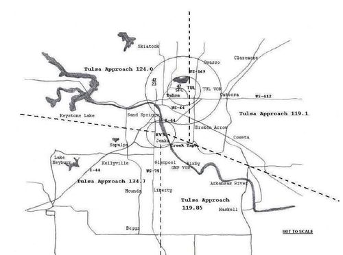
Tulsa Approach and Tulsa Departure
| VHF Frequency | UHF Frequency | Area of Control | Callsign | Note |
|---|---|---|---|---|
| 124.00 | 338.30 | Northwest sector | Tulsa Approach and Tulsa Departure | Primary frequency |
| 119.10 | 351.80 | North East sector | Tulsa Approach and Tulsa Departure | Combined with Northwest Sector during times of low traffic |
| 134.70 | n/a | Southwest sector | Tulsa Approach and Tulsa Departure | Combined with Northwest sector (124.00/338.30) during times of low traffic |
| 119.85 | 381.20 | Southwest Sector | Tulsa Approach and Tulsa Departure | Combined with Southwest Sector or Northwest Sector (134.70) 99% of time |
| 132.10 | 319.90 | Tulsa Inner Class C | Tulsa Approach and Tulsa Departure | Combined with Northwest sector (124.00/338.30) 99% of time |
