Difference between revisions of "QDP2012/39"
From The RadioReference Wiki
< User:QDP2012
m (.) |
m (.) |
||
| Line 1: | Line 1: | ||
| − | (From: [[US Forest Service - | + | (From: [[US Forest Service - Eldorado National Forest (CA)]] ) |
{{USFSinCA}} | {{USFSinCA}} | ||
| − | == ''' | + | == '''Eldorado National Forest (ENF - Forest #03) "Camino" KSB 8-0-1''' == |
| − | |||
| − | The | + | Established in 1910, the Eldorado National Forest is located on the west slope of the central Sierra Nevada. It ranges in elevation from 1,000 feet in the foothills to more than 10,000 feet above sea level along the Sierra crest. A complicated ownership pattern exists. The parcels of other ownership (private or other Agency land) are mostly isolated and surrounded on all sides by National Forest land. An opposite pattern occurs outside of the main forest boundary where several small scattered pieces of National Forest lands are separated from the main body and surrounded by lands of other ownership. The area within the boundary of the forest is 786,994 acres of which 190,270 acres is private or in other government agency ownership. The remaining 596,724 acres is National Forest land. |
| − | The | + | The mountainous topography is broken by the steep canyons of the Mokelumne, Cosumnes, American, and Rubicon rivers. Plateaus of generally moderate relief are located between these steep canyons. The principal vegetation types found on the forest are woodland, chaparral, mixed conifer, true fir, and subalpine. A wide variety of hardwoods, brush, grasses, and forbs are mixed in with each of these forest types. Water is a major resource of the Eldorado National Forest. The average acre on the Forest receives about 56 inches of precipitation annually. Average annual runoff is about 29 inches. This is roughly equal to a yield of 2.4 acre-feet of water per acre of land per year; therefore National Forest lands yield an estimated 1,444,000 acre-feet annually An acre foot of water is equivalent to 325,850 gallons of water, the amount consumed in one year by the average household of 4 people. |
| + | Old growth totaling 122,000 acres have been identified in the Eldorado National Forest, consisting of: Douglas-fir (''Pseudotsuga menziesii var. menziesii''), Ponderosa Pine (''Pinus ponderosa''), White Fir (''Abies concolor''), Lodgepole Pine (''Pinus contorta'') and Red Fir (''Abies magnifica''). | ||
| − | + | An interesting fact about the Eldorado concerns it name. The spanish words "El Dorado" translate to "the golden one." Normally el dorado is two words, but the forest has spelled it as one word. The story is told that a clerk accidentally placed a small "d" after El, rather than separating El from Dorado, like the county of a similar name. The Forest Supervisor apparently liked the differentiation and the name "Eldorado" stuck. | |
| + | The forest is located within 3 - 4 hours driving time from the San Francisco Bay Area, a metropolitan complex of 4.5 million people. Sacramento is located within 1 - 1 1/2 hours driving time from the forest with a population of over 1,000,000 people. The forest is divided into the Amador (District 1), Georgetown (District 3), Pacific (District 5) and Placerville (District 6) and Ranger Districts with the Forest Supervisor's Office in Placerville. | ||
| + | |||
| + | |||
| + | |||
| + | ==='''ELDORADO NATIONAL FOREST - RANGER DISTRICT MAP'''=== | ||
| + | <gallery> | ||
| + | File:R5 Eldorado NF RD Map 2014.JPG|R5 Eldorado NF RD Map 2014.JPG | ||
| + | </gallery> | ||
==='''RADIO SYSTEM'''=== | ==='''RADIO SYSTEM'''=== | ||
| − | + | The Eldorado National Forest has 3 nets, Forest, Admin and Service. The Eldorado National Forest uses microwave linked remote bases and has some UHF frequencies allocated to it. At one time there were remote bases on Bald Mtn. (Supervisor's Office and Georgetown RD), Big Hill (Supervisor's Office and Pacific RD), Leek Springs (Supervisor's Office and Placerville RD), Argonaut Hill (UFH linked)(Amador RD), Water Tank (Lumberyard Ranger Station) and winter use of Leek Springs by the Amador Ranger District. The current remote base locations are unknown. There are 11 repeater sites with all three nets at each site. The Eldorado National Forest does not use channel numbers to describe the frequencies it uses, rather it describes them by name. Channel plans vary based on the ranger district and function to which they are assigned. The names are shown below under "Description" for each channel. | |
| + | |||
| + | Direct or simplex communications are not conducted on the forest's repeater nets such as Forest Net. Tactical frequencies are used instead. Almost all handheld radios in use by the Forest Service are the Bendix-King. These radios have 16 groups and 16 channels per group with only one group can be used at a time. By eliminating the simplex operation of the 5 Forest Service and 3 Cal Fire repeater nets the forest uses, 8 channels are available for other frequencies. The repeater's input tone is transmitted on the output frequency. | ||
==='''Other'''=== | ==='''Other'''=== | ||
| − | The unit | + | The unit identifier system for non fire management personnel is unknown. At one time it used the district number, '''function number''' and position number system. The functions were numbered as follows: 1 District Ranger, 3 Resources, 4 Recreation, 5 Fuels Management and 7 Timber Management. The Eldorado National Forest Dispatch Center is co-located with Cal Fire's Camino Interagency Dispatch Center. It also dispatches for the U.S. Forest Service Lake Tahoe Basin Management Unit. It is a 24 hour operation. The Center's call sign is "Camino." |
| − | ==='''Channel Plan'''=== | + | |
| + | ==='''Channel Plan''' === | ||
{| border="4" cellpadding="4" cellspacing="0" style="margin: 1em 1em 1em 0; background: #f9f9f9; border: 2px #777777 solid; border-collapse: collapse;" class="wikitable sortable" | {| border="4" cellpadding="4" cellspacing="0" style="margin: 1em 1em 1em 0; background: #f9f9f9; border: 2px #777777 solid; border-collapse: collapse;" class="wikitable sortable" | ||
| − | |+ style="font-size: larger" | ''' | + | |+ style="font-size: larger" | '''Eldorado National Forest Channel Lineup''' |
|'''Channel '''||'''Tone(s) '''||'''Rx '''||'''Tx '''||'''Alpha Tag '''||'''Description ''' | |'''Channel '''||'''Tone(s) '''||'''Rx '''||'''Tx '''||'''Alpha Tag '''||'''Description ''' | ||
|- | |- | ||
| − | |||
|- | |- | ||
| − | | | + | |***||1-11||171.5250||169.9500||ENF Forest||Forest Net |
|- | |- | ||
| − | | | + | |***||1-11||172.3250||173.7625||ENF Admin||Admin Net |
|- | |- | ||
| − | | | + | |***||1-11||164.1250||164.8250||ENF Service||Service Net |
|- | |- | ||
| − | | | + | |***||1,2,3||172.3750||164.9625||TMU Fire||Lake Tahoe Basin Management Unit Fire Net (Commonly referred to as "Basin Fire") |
|- | |- | ||
| − | | | + | |***||1,2,3||171.5750||165.4125||TMU Admin||Lake Tahoe Basin Management Unit Admin Net (Commonly referred to as "Basin Admin") |
|- | |- | ||
| − | | | + | |***||1-8||151.1900||159.2250||AEU Local||Cal Fire Amador-Eldorado Local Net Tone 5 (145.2) Rx Side |
|- | |- | ||
| − | | | + | |***||1-16||155.9025||159.2275||Eldr Cmd||Eldorado County Command |
|- | |- | ||
| − | | | + | |***||2,4||153.9350||158.880||Amdr Cmd||Amador County Command (Note: Tone 2 - 123.0 Rx Side) |
|- | |- | ||
| − | | | + | |***||||168.0500||168.0500||NIFC T1||NIFC Tac 1 |
|- | |- | ||
| − | | | + | |***||||168.2000||168.2000||NIFC T2||NIFC Tac 2 |
|- | |- | ||
| − | | | + | |***||||168.6000||168.6000||NIFC T3||NIFC Tac 3 |
|- | |- | ||
| − | | | + | |***||||166.5500||168.5500||R5 T4||R5 Tac 4 |
|- | |- | ||
| − | | | + | |***||||167.1125||167.1125||R5 T5||R5 Tac 5 |
|- | |- | ||
| − | | | + | |***||||168.2375||168.2375||R5 T6||R5 Tac 6 |
|- | |- | ||
| − | | | + | |***||||168.6625||168.6625||R5 Project||R5 Project Net |
|- | |- | ||
| + | |***||||151.1600||151.1600||CF T2||Cal Fire Tac 2 (Note: Tone 16 - 192.8 Rx Side) | ||
| + | |- | ||
| + | |***||||151.3700||151.3700||CF T8||Cal Fire Tac 8 (Note: Tone 16 - 192.8 Rx Side) | ||
| + | |- | ||
| + | |***||||151.3850||151.3850||CF T9||Cal Fire Tac 9 (Note: Tone 16 - 192.8 Rx Side) | ||
| + | |- | ||
| + | |***||||151.2200||151.2200||CF A/G||Cal Fire Air to Ground | ||
| + | |- | ||
| + | |***||||167.5000||167.5000||CA 2 A/G 14 (P)||National Air Ground 14 - CA Zone 2 Primary | ||
| + | |- | ||
| + | |***||||169.1125||169.1125||CA 2 A/G 59 (S)||National Air Ground 59 - CA Zone 2 Secondary | ||
| + | |- | ||
| + | |||
|} | |} | ||
| − | + | ==='''Channel Plan Upcoming Changes''' === | |
| − | ==='''Channel Plan Upcoming Changes'''=== | ||
{| border="4" cellpadding="4" cellspacing="0" style="margin: 1em 1em 1em 0; background: #f9f9f9; border: 2px #777777 solid; border-collapse: collapse;" class="wikitable sortable" | {| border="4" cellpadding="4" cellspacing="0" style="margin: 1em 1em 1em 0; background: #f9f9f9; border: 2px #777777 solid; border-collapse: collapse;" class="wikitable sortable" | ||
| − | |+ style="font-size: larger" | ''' | + | |+ style="font-size: larger" | '''Eldorado National Forest Channel Lineup''' |
|'''Channel '''||'''Tone(s) '''||'''Rx '''||'''Tx '''||'''Alpha Tag '''||'''Description ''' | |'''Channel '''||'''Tone(s) '''||'''Rx '''||'''Tx '''||'''Alpha Tag '''||'''Description ''' | ||
|- | |- | ||
| − | |||
|- | |- | ||
| − | | | + | |***||1-11||171.5250||162.7500||ENF Forest||Forest Net (Changing in 2017) |
| + | |- | ||
| + | |***||1-11||172.3250||165.2250||ENF Admin||Admin Net (Changing Fall 2016) | ||
| + | |- | ||
| + | |***||1-11||173.7625||164.8250||ENF Service||Service Net (Changing Fall 2016) | ||
|- | |- | ||
|} | |} | ||
| Line 80: | Line 105: | ||
==='''Tones'''=== | ==='''Tones'''=== | ||
| − | + | Repeater input tones transmitted on the output frequency. | |
{| border="4" cellpadding="4" cellspacing="0" style="margin: 1em 1em 1em 0; background: #f9f9f9; border: 2px #777777 solid; border-collapse: collapse; float;" | {| border="4" cellpadding="4" cellspacing="0" style="margin: 1em 1em 1em 0; background: #f9f9f9; border: 2px #777777 solid; border-collapse: collapse; float;" | ||
| − | |+ style="font-size: larger; font-weight: bold;" | | + | |+ style="font-size: larger; font-weight: bold;" |ENF Repeaters |
!Tone | !Tone | ||
!Location | !Location | ||
!CTCSS Tone | !CTCSS Tone | ||
|- | |- | ||
| − | |1 | + | |1||Alder Ridge||110.9 |
| − | | | ||
| − | |110.9 | ||
| − | |||
| − | |||
| − | |||
| − | |||
| − | |||
| − | |||
| − | |||
| − | |||
|- | |- | ||
| − | | | + | |2||Leek Springs Hill||123.0 |
| − | | | ||
| − | | | ||
|- | |- | ||
| − | | | + | |3||Bald Mtn.||131.8 |
| − | | | ||
| − | | | ||
|- | |- | ||
| − | | | + | |4||Big Hill||136.5 |
| − | | | ||
| − | | | ||
|- | |- | ||
| − | | | + | |5||Pine Hill||146.2 |
| − | | | ||
| − | | | ||
|- | |- | ||
| − | | | + | |6||Echo Summit||156.7 |
| − | | | ||
| − | | | ||
|- | |- | ||
| − | | | + | |7||Mt. Reba||167.9 |
| − | | | ||
| − | | | ||
|- | |- | ||
| − | | | + | |8||Bunker Hill||103.5 |
| − | | | ||
| − | | | ||
|- | |- | ||
| − | | | + | |9||Hawkins Peak||100.0 |
| − | | | ||
| − | | | ||
|- | |- | ||
| − | | | + | |10||Walker Ridge||107.2 |
| − | | | ||
| − | | | ||
|- | |- | ||
| + | |11||Sourdough Hill||114.8 | ||
|} | |} | ||
Revision as of 19:19, 29 June 2016
(From: US Forest Service - Eldorado National Forest (CA) )
| US Forests in California: | |||||
| Angeles | Inyo | Lassen | Modoc | Sequoia | Six Rivers |
| Cleveland | Klamath | Los Padres | Plumas | Shasta-Trinity | Stanislaus |
| Eldorado | Lake Tahoe BMU | Mendocino | San Bernardino | Sierra | Tahoe |
Contents
Eldorado National Forest (ENF - Forest #03) "Camino" KSB 8-0-1
Established in 1910, the Eldorado National Forest is located on the west slope of the central Sierra Nevada. It ranges in elevation from 1,000 feet in the foothills to more than 10,000 feet above sea level along the Sierra crest. A complicated ownership pattern exists. The parcels of other ownership (private or other Agency land) are mostly isolated and surrounded on all sides by National Forest land. An opposite pattern occurs outside of the main forest boundary where several small scattered pieces of National Forest lands are separated from the main body and surrounded by lands of other ownership. The area within the boundary of the forest is 786,994 acres of which 190,270 acres is private or in other government agency ownership. The remaining 596,724 acres is National Forest land.
The mountainous topography is broken by the steep canyons of the Mokelumne, Cosumnes, American, and Rubicon rivers. Plateaus of generally moderate relief are located between these steep canyons. The principal vegetation types found on the forest are woodland, chaparral, mixed conifer, true fir, and subalpine. A wide variety of hardwoods, brush, grasses, and forbs are mixed in with each of these forest types. Water is a major resource of the Eldorado National Forest. The average acre on the Forest receives about 56 inches of precipitation annually. Average annual runoff is about 29 inches. This is roughly equal to a yield of 2.4 acre-feet of water per acre of land per year; therefore National Forest lands yield an estimated 1,444,000 acre-feet annually An acre foot of water is equivalent to 325,850 gallons of water, the amount consumed in one year by the average household of 4 people.
Old growth totaling 122,000 acres have been identified in the Eldorado National Forest, consisting of: Douglas-fir (Pseudotsuga menziesii var. menziesii), Ponderosa Pine (Pinus ponderosa), White Fir (Abies concolor), Lodgepole Pine (Pinus contorta) and Red Fir (Abies magnifica).
An interesting fact about the Eldorado concerns it name. The spanish words "El Dorado" translate to "the golden one." Normally el dorado is two words, but the forest has spelled it as one word. The story is told that a clerk accidentally placed a small "d" after El, rather than separating El from Dorado, like the county of a similar name. The Forest Supervisor apparently liked the differentiation and the name "Eldorado" stuck.
The forest is located within 3 - 4 hours driving time from the San Francisco Bay Area, a metropolitan complex of 4.5 million people. Sacramento is located within 1 - 1 1/2 hours driving time from the forest with a population of over 1,000,000 people. The forest is divided into the Amador (District 1), Georgetown (District 3), Pacific (District 5) and Placerville (District 6) and Ranger Districts with the Forest Supervisor's Office in Placerville.
ELDORADO NATIONAL FOREST - RANGER DISTRICT MAP
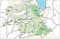
R5 Eldorado NF RD Map 2014.JPG

RADIO SYSTEM
The Eldorado National Forest has 3 nets, Forest, Admin and Service. The Eldorado National Forest uses microwave linked remote bases and has some UHF frequencies allocated to it. At one time there were remote bases on Bald Mtn. (Supervisor's Office and Georgetown RD), Big Hill (Supervisor's Office and Pacific RD), Leek Springs (Supervisor's Office and Placerville RD), Argonaut Hill (UFH linked)(Amador RD), Water Tank (Lumberyard Ranger Station) and winter use of Leek Springs by the Amador Ranger District. The current remote base locations are unknown. There are 11 repeater sites with all three nets at each site. The Eldorado National Forest does not use channel numbers to describe the frequencies it uses, rather it describes them by name. Channel plans vary based on the ranger district and function to which they are assigned. The names are shown below under "Description" for each channel.
Direct or simplex communications are not conducted on the forest's repeater nets such as Forest Net. Tactical frequencies are used instead. Almost all handheld radios in use by the Forest Service are the Bendix-King. These radios have 16 groups and 16 channels per group with only one group can be used at a time. By eliminating the simplex operation of the 5 Forest Service and 3 Cal Fire repeater nets the forest uses, 8 channels are available for other frequencies. The repeater's input tone is transmitted on the output frequency.
Other
The unit identifier system for non fire management personnel is unknown. At one time it used the district number, function number and position number system. The functions were numbered as follows: 1 District Ranger, 3 Resources, 4 Recreation, 5 Fuels Management and 7 Timber Management. The Eldorado National Forest Dispatch Center is co-located with Cal Fire's Camino Interagency Dispatch Center. It also dispatches for the U.S. Forest Service Lake Tahoe Basin Management Unit. It is a 24 hour operation. The Center's call sign is "Camino."
Channel Plan
| Channel | Tone(s) | Rx | Tx | Alpha Tag | Description |
| *** | 1-11 | 171.5250 | 169.9500 | ENF Forest | Forest Net |
| *** | 1-11 | 172.3250 | 173.7625 | ENF Admin | Admin Net |
| *** | 1-11 | 164.1250 | 164.8250 | ENF Service | Service Net |
| *** | 1,2,3 | 172.3750 | 164.9625 | TMU Fire | Lake Tahoe Basin Management Unit Fire Net (Commonly referred to as "Basin Fire") |
| *** | 1,2,3 | 171.5750 | 165.4125 | TMU Admin | Lake Tahoe Basin Management Unit Admin Net (Commonly referred to as "Basin Admin") |
| *** | 1-8 | 151.1900 | 159.2250 | AEU Local | Cal Fire Amador-Eldorado Local Net Tone 5 (145.2) Rx Side |
| *** | 1-16 | 155.9025 | 159.2275 | Eldr Cmd | Eldorado County Command |
| *** | 2,4 | 153.9350 | 158.880 | Amdr Cmd | Amador County Command (Note: Tone 2 - 123.0 Rx Side) |
| *** | 168.0500 | 168.0500 | NIFC T1 | NIFC Tac 1 | |
| *** | 168.2000 | 168.2000 | NIFC T2 | NIFC Tac 2 | |
| *** | 168.6000 | 168.6000 | NIFC T3 | NIFC Tac 3 | |
| *** | 166.5500 | 168.5500 | R5 T4 | R5 Tac 4 | |
| *** | 167.1125 | 167.1125 | R5 T5 | R5 Tac 5 | |
| *** | 168.2375 | 168.2375 | R5 T6 | R5 Tac 6 | |
| *** | 168.6625 | 168.6625 | R5 Project | R5 Project Net | |
| *** | 151.1600 | 151.1600 | CF T2 | Cal Fire Tac 2 (Note: Tone 16 - 192.8 Rx Side) | |
| *** | 151.3700 | 151.3700 | CF T8 | Cal Fire Tac 8 (Note: Tone 16 - 192.8 Rx Side) | |
| *** | 151.3850 | 151.3850 | CF T9 | Cal Fire Tac 9 (Note: Tone 16 - 192.8 Rx Side) | |
| *** | 151.2200 | 151.2200 | CF A/G | Cal Fire Air to Ground | |
| *** | 167.5000 | 167.5000 | CA 2 A/G 14 (P) | National Air Ground 14 - CA Zone 2 Primary | |
| *** | 169.1125 | 169.1125 | CA 2 A/G 59 (S) | National Air Ground 59 - CA Zone 2 Secondary |
Channel Plan Upcoming Changes
| Channel | Tone(s) | Rx | Tx | Alpha Tag | Description |
| *** | 1-11 | 171.5250 | 162.7500 | ENF Forest | Forest Net (Changing in 2017) |
| *** | 1-11 | 172.3250 | 165.2250 | ENF Admin | Admin Net (Changing Fall 2016) |
| *** | 1-11 | 173.7625 | 164.8250 | ENF Service | Service Net (Changing Fall 2016) |
Tones
Repeater input tones transmitted on the output frequency.
| Tone | Location | CTCSS Tone |
|---|---|---|
| 1 | Alder Ridge | 110.9 |
| 2 | Leek Springs Hill | 123.0 |
| 3 | Bald Mtn. | 131.8 |
| 4 | Big Hill | 136.5 |
| 5 | Pine Hill | 146.2 |
| 6 | Echo Summit | 156.7 |
| 7 | Mt. Reba | 167.9 |
| 8 | Bunker Hill | 103.5 |
| 9 | Hawkins Peak | 100.0 |
| 10 | Walker Ridge | 107.2 |
| 11 | Sourdough Hill | 114.8 |
Related Links
- National Incident Radio Support Cache - These frequencies are used for large incidents, usually when a Type I or Type II Incident Management Team is assigned. This cache is used for fires, floods, tornadoes, hurricanes, visits of high ranking officials, such the U.S. President and the presidents of other countries, large law enforcement incidents, special events and other incidents where the federal government is utilizing the Incident Command System.
Return to DB page: United States Forest Service (CA)
| US Forests in California: | |||||
| Angeles | Inyo | Lassen | Modoc | Sequoia | Six Rivers |
| Cleveland | Klamath | Los Padres | Plumas | Shasta-Trinity | Stanislaus |
| Eldorado | Lake Tahoe BMU | Mendocino | San Bernardino | Sierra | Tahoe |