Difference between revisions of "Wake County (NC)"
From The RadioReference Wiki
| (23 intermediate revisions by 5 users not shown) | |||
| Line 1: | Line 1: | ||
| − | ==Raleigh Police Department | + | ==Using Google Earth to view Raleigh Police Department Districts/Beats== |
| − | + | Google Earth can now be used to view every Raleigh PD Beat & District. | |
| + | It is Very easy to setup: | ||
| − | + | *Go to [http://earth.google.com Google Earth] and download Google Earth and install it for your operating system. It is available for most operating systems. | |
| − | + | *Download this zip file from RR.com: [[Media:RPDKMLFiles.zip|RPDKMLFiles.Zip]] | |
| − | [[ | ||
| − | |||
| − | |||
| − | |||
| − | + | *Unzip and Extract the 2 files in the RPDKMLFiles.zip file you just downloaded. | |
| − | |||
| − | |||
| − | + | **The 2 Files you should now have are named: | |
| − | + | **New Beats.kml | |
| − | + | **New District.kml | |
| − | |||
| − | |||
| − | |||
| − | |||
| − | |||
| − | |||
| − | |||
| − | |||
| − | |||
| − | |||
| − | |||
| − | |||
| − | |||
| − | |||
| − | |||
| − | |||
| − | |||
| − | |||
| − | |||
| − | |||
| − | |||
| − | |||
| − | |||
| − | |||
| − | |||
| − | |||
| − | |||
| − | |||
| − | |||
| − | |||
| − | |||
| − | |||
| − | |||
| − | |||
| − | |||
| − | |||
| − | |||
| − | |||
| − | |||
| − | |||
| − | + | *Start up Google Earth and Select "File" then "Open" as shown below: | |
| − | + | [[Image:1Openkml.JPG]] | |
| − | |||
| − | |||
| − | |||
| − | |||
| − | |||
| − | |||
| − | |||
| − | |||
| − | |||
| − | |||
| − | |||
| − | |||
| − | |||
| − | |||
| − | |||
| − | |||
| − | |||
| − | |||
| − | |||
| − | |||
| − | |||
| − | |||
| − | |||
| − | |||
| − | |||
| − | |||
| − | |||
| − | |||
| − | |||
| − | |||
| − | |||
| − | |||
| − | |||
| − | |||
| − | |||
| − | |||
| − | |||
| − | |||
| − | |||
| − | |||
| − | |||
| − | |||
| − | |||
| − | |||
| − | |||
| − | |||
| − | |||
| − | |||
| − | |||
| − | |||
| − | |||
| − | |||
| − | |||
| − | |||
| − | |||
| − | |||
| − | |||
| − | |||
| − | |||
| − | |||
| − | |||
| − | |||
| − | |||
| − | |||
| − | |||
| − | |||
| − | |||
| − | |||
| − | |||
| − | |||
| − | |||
| − | |||
| − | |||
| − | |||
| − | |||
| − | |||
| − | |||
| − | |||
| − | |||
| − | |||
| − | |||
| − | |||
| − | |||
| − | |||
| − | |||
| − | |||
| − | |||
| − | |||
| − | |||
| − | |||
| − | |||
| − | |||
| − | |||
| − | |||
| − | |||
| − | |||
| − | |||
| − | |||
| − | |||
| − | |||
| − | |||
| − | |||
| − | |||
| − | |||
| − | |||
| − | |||
| − | |||
| − | |||
| − | |||
| − | |||
| − | |||
| − | |||
| − | |||
| − | |||
| − | |||
| − | |||
| − | |||
| − | |||
| − | |||
| − | |||
| − | |||
| − | |||
| − | |||
| − | |||
| − | + | *Select both of the ".kml" files you just saved a few minutes ago and Google Earth | |
| − | + | should import them.<br/> | |
| − | |||
| − | |||
| − | |||
| − | |||
| − | |||
| − | |||
| − | |||
| − | |||
| − | |||
| − | |||
| − | |||
| − | |||
| − | |||
| − | |||
| − | |||
| − | |||
| − | |||
| − | |||
| − | |||
| − | |||
| − | |||
| − | |||
| − | |||
| − | |||
| − | |||
| − | |||
| − | |||
| − | |||
| − | |||
| − | |||
| − | |||
| − | |||
| − | |||
| − | |||
| − | |||
| − | |||
| − | |||
| − | |||
| − | |||
| − | |||
| − | |||
| − | |||
| − | |||
| − | |||
| − | |||
| − | |||
| − | |||
| − | |||
| − | |||
| − | |||
| − | |||
| − | |||
| − | |||
| − | |||
| − | |||
| − | |||
| − | |||
| − | |||
| − | |||
| − | |||
| − | |||
| − | |||
| − | |||
| − | |||
| − | |||
| − | |||
| − | |||
| − | |||
| − | |||
| − | |||
| − | |||
| − | |||
| − | |||
| − | |||
| − | |||
| − | |||
| − | |||
| − | |||
| − | |||
| − | |||
| − | |||
| − | |||
| − | |||
| − | |||
| − | |||
| − | |||
| − | |||
| − | |||
| − | |||
| − | |||
| − | |||
| − | |||
| − | |||
| − | |||
| − | |||
| − | |||
| − | |||
| − | |||
| − | |||
| − | |||
| − | |||
| − | |||
| − | |||
| − | |||
| − | |||
| − | |||
| − | |||
| − | |||
| − | |||
| − | |||
| − | |||
| − | |||
| − | |||
| − | |||
| − | |||
| − | |||
| − | |||
| − | |||
| − | |||
| − | |||
| − | |||
| − | |||
| − | |||
| − | |||
| − | |||
| − | |||
| − | |||
| − | |||
| − | |||
| − | |||
| − | |||
| − | |||
| − | |||
| − | |||
| − | |||
| − | |||
| − | |||
| − | |||
| − | |||
| − | |||
| − | |||
| − | |||
| − | |||
| − | |||
| − | |||
| − | |||
| − | |||
| − | |||
| − | |||
| − | |||
| − | |||
| − | |||
| − | |||
| − | |||
| − | |||
| − | |||
| − | |||
| − | |||
| − | |||
| − | |||
| − | |||
| − | |||
| − | |||
| − | |||
| − | |||
| − | |||
| − | |||
| − | |||
| − | |||
| − | |||
| − | |||
| − | |||
| − | |||
| − | |||
| − | |||
| − | |||
| − | |||
| − | |||
| − | |||
| − | |||
| − | |||
| − | |||
| − | |||
| − | |||
| − | |||
| − | |||
| − | |||
| − | |||
| − | |||
| − | |||
| − | |||
| − | |||
| − | |||
| − | |||
| − | |||
| − | |||
| − | |||
| − | |||
| − | |||
| − | |||
| − | |||
| − | |||
| − | |||
| − | |||
| − | |||
| − | |||
| − | |||
| − | |||
| − | |||
| − | |||
| − | |||
| − | |||
| − | |||
| − | |||
| − | |||
| − | |||
| − | |||
| − | |||
| − | |||
| − | |||
| − | |||
| − | |||
| − | |||
| − | |||
| − | |||
| − | |||
| − | |||
| − | |||
| − | |||
| − | |||
| − | |||
| − | |||
| − | |||
| − | |||
| − | |||
| − | |||
| − | |||
| − | |||
| − | |||
| − | |||
| − | |||
| − | |||
| − | |||
| − | |||
| − | |||
| − | |||
| − | |||
| − | |||
| − | |||
| − | |||
| − | |||
| − | |||
| − | |||
| − | |||
| − | |||
| − | |||
| − | |||
| − | |||
| − | |||
| − | |||
| − | |||
| − | |||
| − | |||
| − | |||
| − | |||
| − | |||
| − | |||
| − | |||
| − | |||
| − | |||
| − | |||
| − | |||
| − | |||
| − | |||
| − | |||
| − | |||
| − | |||
| − | |||
| − | |||
| − | |||
| − | |||
| − | |||
| − | |||
| − | |||
| − | |||
| − | |||
| − | |||
| − | |||
| − | |||
| − | |||
| − | |||
| − | |||
| − | |||
| − | |||
| − | |||
| − | |||
| − | |||
| − | |||
| − | |||
| − | |||
| − | |||
| − | |||
| − | |||
| − | |||
| − | |||
| − | |||
| − | |||
| − | |||
| − | |||
| − | |||
| − | |||
| − | |||
| − | |||
| − | |||
| − | |||
| − | |||
| − | |||
| − | |||
| − | |||
| − | |||
| − | |||
| − | |||
| − | |||
| − | |||
| − | |||
| − | |||
| − | |||
| − | |||
| − | |||
| − | |||
| − | |||
| − | |||
| − | |||
| − | |||
| − | |||
| − | |||
| − | |||
| − | |||
| − | |||
| − | |||
| − | |||
| − | |||
| − | |||
| − | |||
| − | |||
| − | |||
| − | |||
| − | |||
| − | |||
| − | |||
| − | |||
| − | |||
| − | |||
| − | |||
| − | |||
| − | |||
| − | |||
| − | |||
| − | |||
| − | |||
| − | |||
| − | |||
| − | |||
| − | |||
| − | |||
| − | |||
| − | |||
| − | |||
| − | |||
| − | |||
| − | |||
| − | |||
| − | |||
| − | |||
| − | |||
| − | |||
| − | |||
| − | |||
| − | |||
| − | |||
| − | |||
| − | |||
| − | |||
| − | |||
| − | |||
| − | |||
| − | |||
| − | |||
| − | |||
| − | |||
| − | |||
| − | |||
| − | |||
| − | |||
| − | |||
| − | |||
| − | |||
| − | |||
| − | |||
| − | |||
| − | |||
| − | |||
| − | |||
| − | |||
| − | |||
| − | |||
| − | |||
| − | |||
| − | |||
| − | |||
| − | |||
| − | |||
| − | |||
| − | |||
| − | |||
| − | |||
| − | |||
| − | |||
| − | |||
| − | |||
| − | |||
| − | |||
| − | |||
| − | |||
| − | |||
| − | |||
| − | |||
| − | |||
| − | |||
| − | |||
| − | |||
| − | |||
| − | |||
| − | |||
| − | |||
| − | |||
| − | |||
| − | |||
| − | |||
| − | |||
| − | |||
| − | |||
| − | |||
| − | |||
| − | |||
| − | |||
| − | |||
| − | |||
| − | |||
| − | |||
| − | |||
| − | |||
| − | |||
| − | |||
| − | |||
| − | |||
| − | |||
| − | |||
| − | |||
| − | |||
| − | |||
| − | |||
| − | |||
| − | |||
| − | |||
| − | |||
| − | |||
| − | |||
| − | |||
| − | |||
| − | |||
| − | |||
| − | |||
| − | |||
| − | |||
| − | |||
| − | |||
| − | |||
| − | |||
| − | |||
| − | |||
| − | |||
| − | |||
| − | |||
| − | |||
| − | |||
| − | |||
| − | |||
| − | |||
| − | |||
| − | |||
| − | |||
| − | |||
| − | |||
| − | |||
| − | |||
| − | |||
| − | |||
| − | |||
| − | |||
| − | |||
| − | |||
| − | |||
| − | |||
| − | |||
| − | |||
| − | |||
| − | |||
| − | |||
| − | |||
| − | |||
| − | |||
| − | |||
| − | |||
| − | |||
| − | |||
| − | |||
| − | |||
| − | |||
| − | |||
| − | |||
| − | |||
| − | |||
| − | |||
| − | |||
| − | |||
| − | |||
| − | |||
| − | |||
| − | |||
| − | |||
| − | |||
| − | |||
| − | |||
| − | |||
| − | |||
| − | |||
| − | |||
| − | |||
| − | |||
| − | |||
| − | |||
| − | |||
| − | |||
| − | |||
| − | |||
| − | |||
| − | |||
| − | |||
| − | |||
| − | |||
| − | |||
| − | |||
| − | |||
| − | |||
| − | |||
| − | |||
| − | |||
| − | |||
| − | |||
| − | |||
| − | |||
| − | |||
| − | |||
| − | |||
| − | |||
| − | |||
| − | |||
| − | |||
| − | |||
| − | |||
| − | |||
| − | |||
| − | |||
| − | |||
| − | |||
| − | |||
| − | |||
| − | |||
| − | |||
| − | |||
| − | |||
| − | |||
| − | |||
| − | |||
| − | |||
| − | |||
| − | |||
| − | |||
| − | |||
| − | |||
| − | |||
| − | |||
| − | |||
| − | |||
| − | |||
| − | |||
| − | |||
| − | |||
| − | |||
| − | |||
| − | |||
| − | |||
| − | |||
| − | |||
| − | |||
| − | |||
| − | |||
| − | |||
| − | |||
| − | |||
| − | |||
| − | |||
| − | |||
| − | |||
| − | |||
| − | |||
| − | |||
| − | |||
| − | |||
| − | |||
| − | |||
| − | |||
| − | |||
| − | |||
| − | |||
| − | |||
| − | |||
| − | |||
| − | |||
| − | |||
| − | |||
| − | |||
| − | |||
| − | |||
| − | |||
| − | |||
| − | |||
| − | |||
| − | |||
| − | |||
| − | |||
| − | |||
| − | |||
| − | |||
| − | |||
| − | |||
| − | |||
| − | |||
| − | |||
| − | |||
| − | |||
| − | |||
| − | |||
| − | |||
| − | |||
| − | |||
| − | |||
| − | |||
| − | + | *If successful you should see the new beats/districts in the places column on the left hand side: | |
| − | + | [[Image:2places.JPG]] | |
| − | |||
| − | |||
| − | |||
| − | |||
| − | |||
| − | + | *And you should be able to click on them and see something like the Image Below: | |
| − | + | <gallery> | |
| − | + | Image:3citywide.JPG|CityWide Map<br/>(Click to enlarge) | |
| − | + | </gallery> | |
| − | |||
| − | |||
| − | |||
| − | |||
| − | |||
| − | |||
| − | |||
| − | |||
| − | |||
| − | |||
| − | |||
| − | |||
| − | |||
| − | |||
| − | |||
| − | |||
| − | |||
| − | |||
| − | |||
| − | |||
| − | |||
| − | |||
| − | |||
| − | |||
| − | |||
| − | |||
| − | |||
| − | |||
| − | |||
| − | |||
| − | |||
| − | |||
| − | |||
| − | |||
| − | |||
| − | |||
| − | |||
| − | |||
| − | |||
| − | |||
| − | |||
| − | |||
| − | |||
| − | |||
| − | |||
| − | |||
| − | |||
| − | |||
| − | |||
| − | |||
| − | + | *You now have the ability to zoom in to street level and out and click on individual Beats/Districts and see which beats cover which areas. | |
| − | |||
| − | |||
| − | |||
| − | |||
| − | |||
| − | |||
| − | |||
| − | |||
| − | |||
| − | |||
| − | |||
| − | |||
| − | |||
| − | |||
| − | |||
| − | |||
| − | |||
| − | |||
| − | |||
| − | |||
| − | |||
| − | |||
| − | |||
| − | |||
| − | |||
| − | |||
| − | |||
| − | |||
| − | |||
| − | |||
| − | |||
| − | |||
| − | |||
| − | |||
| − | |||
| − | |||
| − | |||
| − | |||
| − | |||
| − | |||
| − | |||
| − | |||
| − | |||
| − | |||
| − | |||
| − | |||
| − | |||
| − | |||
| − | |||
| − | |||
| − | |||
| − | |||
| − | |||
| − | |||
| − | |||
| − | |||
| − | |||
| − | |||
| − | |||
| + | <br style="clear:both" /> | ||
==Wake County Sheriff Unit Numbering== | ==Wake County Sheriff Unit Numbering== | ||
*100 units are administrative | *100 units are administrative | ||
| Line 983: | Line 42: | ||
The zone map is mainly just for assignment purposes. Road deputies are assigned to a zone or zones at the beginning of their shift. They will usually be assigned calls in their zone or an adjacent zone if needed. | The zone map is mainly just for assignment purposes. Road deputies are assigned to a zone or zones at the beginning of their shift. They will usually be assigned calls in their zone or an adjacent zone if needed. | ||
| − | ==Wake County Sheriff Dept | + | ==Wake County Sheriff Dept Maps== |
| − | + | <gallery> | |
| + | image:Wakesozones.jpg|Dept Zone Layout | ||
| + | Image:GPDBeatmap.jpg|Dept Beat Map | ||
| + | </gallery> | ||
| + | |||
<br style="clear:both" /> | <br style="clear:both" /> | ||
==Raleigh/Wake County 10 Codes/Signals== | ==Raleigh/Wake County 10 Codes/Signals== | ||
| − | + | <gallery> | |
| − | < | + | image:RaleighTencodes.jpg|Raleigh Ten Codes |
| − | [[Media:Wake 10 Codessmall.pdf|Wake County Ten Codes/Signals Pocket Sized]] | + | </gallery> |
| − | + | *[[Media:Wake 10 Codessmall.pdf|Wake County Ten Codes/Signals Pocket Sized]] | |
| − | [[media:WakeCoTenCodesSignals.pdf|Wake County Ten Codes/Signals]] | + | *[[media:WakeCoTenCodesSignals.pdf|Wake County Ten Codes/Signals]] |
| + | |||
| + | ==Raleigh (NC) Fire Dept. ({{Callsign|WPCI922}})== | ||
| + | |||
| + | * '''Sta. #1''' - 220 S. Dawson St. (aka State Route 50/US-70/US-401) between W. Hargett St. & W. Martin St. '''({{Callsign|KII313}})''' (Engine 1/Engine 13/Ladder 4/Fire Invest Unit/Car 401/Car 402) | ||
| + | * '''Sta. #2''' - 263 Pecan Rd. between S. Saunders St. (aka State Route 50/US-70/US-401) & Renfrow Rd. '''({{Callsign|KII313}})''' (Engine 2/Haz-Mat 1) | ||
| + | * '''Sta. #3''' - 11-13 S. East St. between New Bern Ave. & Morson St. '''({{Callsign|KII313}})''' (Engine 3) | ||
| + | * '''Sta. #4''' - | ||
| + | ** Current Sta. - 121 Northway Ct. @ Horizon Dr. (Engine 4/Ladder 1) | ||
| + | ** Former Sta. - 505 Jefferson St. between Glenwood Ave. & Filmore St. | ||
| + | * '''Sta. #5''' - 300 Oberlin Rd. @ 1920-1922 Park Dr. (Engine 5) | ||
| + | * '''Sta. #6''' - | ||
| + | ** Current Sta. - 2601 Fairview Rd. @ Oberlin Rd. (Engine 6) | ||
| + | ** Former Sta. - 2519 Fairview Rd. between Oberlin Rd. & St. Mary's St. | ||
| + | * '''Sta. #7''' - 2100 Glascock St. @ N. Raleigh Blvd. (Squad 7/Mini-Pumper 2) | ||
| + | * '''Sta. #8''' - | ||
| + | ** Current Sta. - 5001 Western Blvd. between Pineland Cir. & Gannett St. (Engine 8/Battalion 3/Air Truck/Haz-Mat 3) | ||
| + | ** Former Sta. - 1007 Method Rd. between Western Blvd. & Reavis Rd. | ||
| + | * '''Sta. #9''' - 4465 Six Forks Rd. @ Rowan St. (Engine 9/Battalion 5) | ||
| + | * '''Sta. #10''' - 2711 Sanderford Rd. between Seabrook Rd. & Elkpark Dr. (Engine 10) | ||
| + | * '''Sta. #11''' - 2925 Glenridge Dr. between Highwoods Blvd. & Ward Rd. (Engine 11/Ladder 2) | ||
| + | * '''Sta. #12''' - | ||
| + | ** Current Sta. - 4302-4306 Poole Rd. (aka County Route 1007) @ 803-807 Bus Way '''({{Callsign|WNYY760}})''' (Engine 12/Ladder 8/Battalion 2) | ||
| + | ** Former Sta. - 3409 Poole Rd. (aka County Route 1007) between Birch Ridge Dr. & Samuel Rd. | ||
| + | * '''Sta. #14''' - 4220 Lake Boone Trl. between Rexwoods Dr. & Rex Way '''({{Callsign|WNYY760}})''' (Squad 14/Mini-Pumper 3) | ||
| + | * '''Sta. #15''' - 1815 Spring Forest Rd. across from Sentinel Dr. '''({{Callsign|WNYY760}})''' (Engine 15) | ||
| + | * '''Sta. #16''' - 5225 Lead Mine Rd. between Belsay Dr. & Yorkgate Dr. '''({{Callsign|WNYY760}})''' (Engine 16/Rescue 1) | ||
| + | * '''Sta. #17''' - 4601 Pleasant Valley Rd. between Duraleigh Rd. & Grove Church Rd. '''({{Callsign|WNYY760}})''' (Engine 17/Ladder 3) | ||
| + | * '''Sta. #18''' - 8200 Morgans Way @ Creedmoor Rd. (aka State Route 50) '''({{Callsign|WNYY760}})''' (Engine 18/Battalion 4) | ||
| + | * '''Sta. #19''' - 4209 Spring Forest Rd. between Sedgewick Dr. & Somerset Springs Dr. '''({{Callsign|WNYY759}})''' (Engine 19/Battalion 1) | ||
| + | * '''Sta. #20''' - 1721 Trailwood Dr. between Main Campus Dr. & Crump Rd. '''({{Callsign|WNYY759}})''' (Engine 20/Ladder 7) | ||
| + | * '''Sta. #21''' - 2651 Southall Rd. between Eagle Trace Dr. & Skycrest Dr. (Engine 21/Swift Water Rescue 801) | ||
| + | * '''Sta. #22''' - | ||
| + | ** Current Sta. - 9350 Durant Rd. (aka County Route 2006) between Leslieshire Dr. & Hawksmoor Dr. (Engine 22/Ladder 5/Haz-Mat 4) | ||
| + | ** Temporary Sta. - 10231 Falls of Neuse Rd. (aka County Route 2000) between Durant Rd. (aka County Route 2006) & Raven Ridge Rd. (aka County Route 2010) (The Crew Quarters sat at the following coordinates: 35.914376/-78.599710 & the Engine Bay sat at the following coordinates: 35.914405/-78.599965) | ||
| + | * '''Sta. #23''' - 8312 Pinecrest Rd. between Seafarer Ct. & O'Neal Rd. (Engine 23/Ladder 9) (Sta. #23 is shared with the Durham Highway V.F.D. Sta. #2) | ||
| + | * '''Sta. #24''' - 10440 Fossil Creek Ct. between Brier Creek Pkwy. & Dead End (Engine 24/Ladder 6) (Sta. #24 sits at the Dead End) | ||
| + | * '''Sta. #25''' - 2740 Wakefield Crossing Dr. between Queensland Rd. & Berks Way (Engine 25/Ladder 5/Haz-Mat) | ||
| + | * '''Sta. #26''' - 3929 Barwell Rd. between Barwell Park Dr. & Tomahawk Trl. (Engine 26/Ladder 8) | ||
| + | * '''Sta. #27''' - 5916 Buffaloe Rd. (aka County Route 2215) between Woodchurch Ct. & Tallyhoe Dr. (Engine 27/Haz-Mat 5) | ||
| + | * '''Sta. #28''' - 3500 Forestville Rd. (aka County Route 2049) between Mitchell Mill Rd. (aka County Route 2224) & Hopper St. (Engine 28/Ladder 9/Mini-Pumper 1/Air 2) | ||
| + | * '''Sta. #29''' - 12117 Leesville Rd. (aka County Route 1839) @ Englehardt Dr. (Engine 29/Haz-Mat 2) | ||
| + | * '''Capital Hose Co.''' - 115-117 W. Morgan St. between S. McDowell St. (aka State Route 50/US-70/US-401) & S. Salisbury St. '''''***(NOW CLOSED)***''''' | ||
| + | |||
| + | ==Wake County (NC) Fire & Amb. Dept.'s== | ||
| + | * '''Angier & Black River V.F.D. Inc.''' - 309 N. Broad St. E. (aka County Route 1500) between W. Dora St. & E. Wimberly St.,Angier (Hartnett Co.) (Has coverage in Wake Co.) | ||
| + | * '''Apex V.F.D. ({{Callsign|KIP936}}/{{Callsign|WPMJ915}})''' - | ||
| + | ** Sta. #1 - 210 N. Salem St. (aka County Route 1011) between Center St. & Saunders St.,Apex (Sta. #1 is Wake Co. Dept. #4) | ||
| + | ** Sta. #2 - 3045 New Hill Holleman Rd. (aka County Route 1127) between Stewart Rd. & Church Rd. (aka County Route 1166),New Hill (Sta. #2 is Wake Co. Dept. #40) | ||
| + | ** Sta. #3 (HQ) - 736 Hunter St. between W. Chatham St. & Gablefield Ln.,Apex (Sta. #3 is Wake Co. Dept. #44) | ||
| + | ** Sta. #4 - 1607-1615 E. Williams St. (aka State Route 55) between Pristine Water Dr. & Technology Dr. | ||
| + | ** Sta. #5 - 2050 Kelly Rd. @ 6900-6908 Apex Barbecue Rd. | ||
| + | * '''Apex E.M.S.''' - 313-315 W. Williams St. (aka State Route 55) @ Upchurch St. '''''***(DISBANDED)***''''' | ||
| + | * '''Cary F.D. ({{Callsign|KBK537}})''' - | ||
| + | ** HQ - 100 N. Academy St. @ E. Cedar St. | ||
| + | ** Sta. #1 - 1501-1503 N. Harrison Ave. between N.W. Cary Pkwy. & Livingstone Dr. | ||
| + | ** Sta. #2 - 601 E. Chatham St. (aka County Route 1011) @ Reedy Creek Rd. | ||
| + | ** Sta. #3 - 1807 Kildaire Farm Rd. (aka County Route 1300) between Kildaire Park Dr. & Keisler Dr. | ||
| + | ** Sta. #4 - 1401 Old Apex Rd. (aka County Route 1011) between W. Chatham St. (aka County Route 1011) & Marilyn Cir. | ||
| + | ** Sta. #5 - 2101 High House Rd. between Tumbled Way & Cornerstone Dr. | ||
| + | ** Sta. #6 - 3609 Ten-Ten Rd. @ Plumtree Way | ||
| + | ** Sta. #7 - 6900 Carpenter Fire Station Rd. (aka County Route 1624) between State Route 55 & Howard Rd. (Sta. #7 is shared w/Morrisville V.F.D. Sta. #3) | ||
| + | ** Sta. #8 - 408 Mills Park Dr. @ Green Level Church Rd. (aka County Route 1625) | ||
| + | ** Sta. #9 - | ||
| + | *** Current Sta. - 1427 Walnut St. @ Nottingham Dr. | ||
| + | *** Former Sta. - 875 S.E. Maynard Rd. (aka County Route 1415) between Cary Towne Blvd. & Village Greenway | ||
| + | * '''Cary Area E.M.S.''' - 107 Medcon Ct. between Kildaire Farm Rd. (aka County Route 1300) & Kylie Savannah Ct. | ||
| + | * '''Creedmoor V.F.D.''' - 101 S. Elm St. @ W. Lyon St.,Creedmoor (Granville Co.) (Creedmoor V.F.D. has jurisdiction in Wake Co.) | ||
| + | * '''Durham F.D.''' - | ||
| + | ** HQ - 2008 E. Club Blvd. between Camden Ave. & Jones Park Dr.,Durham (Durham Co.) | ||
| + | ** Sta. #1 - | ||
| + | *** Current Sta. - 139 E. Morgan St. (aka Business US-70) @ Cleveland St.,Durham (Durham Co.) | ||
| + | *** Former Sta. - 102 City Hall Plaza @ N. Mangum St. (aka Business US-15/Business US-501),Durham (Durham Co.) | ||
| + | ** Sta. #2 - 1001 Ninth St. @ W. Knox St.,Durham (Durham Co.) | ||
| + | ** Sta. #3 - | ||
| + | *** Current Sta. - 822 N. Miami Blvd. (aka Business US-70) between Holloway St. (aka State Route 98) & Liberty St.,Durham (Durham Co.) | ||
| + | *** Former Sta. - 103 S. Driver St. @ E. Main St.,Durham (Durham Co.) | ||
| + | ** Sta. #4 - | ||
| + | *** Current Sta. - 1818 Riddle Rd. between Apex Hwy. (aka State Route 55) & S. Alston Ave.,Durham (Durham Co.) | ||
| + | *** Former Sta. - 2010 Fayetteville St. (aka County Route 1118) @ Pekoe Ave.,Durham (Durham Co.) | ||
| + | ** Sta. #5 - 2212 Chapel Hill Rd. @ Ward St.,Durham (Durham Co.) | ||
| + | ** Sta. #6 - 3700 Swarthmore Rd. @ Hope Valley Rd. (aka State Route 751),Durham (Durham Co.) | ||
| + | ** Sta. #7 - 3919-3923 N. Duke St. (aka US-501 Bypass) between Holt School Rd. & Monk Rd.,Durham (Durham Co.) | ||
| + | ** Sta. #8 - | ||
| + | *** Current Sta. - 225 Lick Creek Ln. @ Wake Forest Hwy. (aka US-98),Durham (Durham Co.) | ||
| + | *** Former Sta. - 2725 Holloway St. (aka US-98) between S. Woodcrest St. & Rochelle St.,Durham (Durham Co.) ***(Now Durham Co. E.M.S. Sta. #4)*** | ||
| + | ** Sta. #9 - | ||
| + | *** Current Sta. - 1648 Midland Terr. @ Camden Ave.,Durham (Durham Co.) | ||
| + | *** Former Sta. - 2012 E. Club Blvd. @ Camden Ave.,Durham (Durham Co.) | ||
| + | ** Sta. #10 - 1805 Cole Mill Rd. (aka County Route 1401) between Kimball Dr. & Colewood Dr.,Durham (Durham Co.) | ||
| + | ** Sta. #11 - 2800 W. Cornwallis Rd. across from Ridge Rd.,Durham (Durham Co.) | ||
| + | ** Sta. #12 - 1230 Carpenter Fletcher Rd. @ North Bend Dr.,Durham (Durham Co.) | ||
| + | ** Sta. #13 - 2901 S. Miami Blvd. (aka County Route 1959) between Presidential Dr. & Brassfield Rd.,Durham (Durham Co.) (Sta. #13 has coverage in Wake Co.) | ||
| + | ** Sta. #14 - 1327 Umstead Rd. (aka County Route 1449) across from Bivins Rd. (aka County Route 1453),Durham (Durham Co.) | ||
| + | ** Sta. #15 - 2060 Torredge Rd. between Snow Hill Rd. & Dead End,Durham (Durham Co.) | ||
| + | ** Sta. #16 - 6303 Farrington Rd. across from Dunbrook Dr.,Durham (Durham Co.) (Sta. #16 has coverage in Chatham Co.) | ||
| + | ** Sta. #17 - 5503 Leesville Rd. (aka County Route 1975) across from Adventure Trl.,Durham (Durham Co.) | ||
| + | ** Sta. #18 - 1409 Seaton Rd. between Revere Rd. & McCormick Rd.,Durham (Durham Co.) (Sta. #18 was formerly Parkwood V.F.D. Sta. #1 & Durham Co. Fire/Rescue Sta. #83) | ||
| + | ** Sta. #19 - 4716 Old Page Rd. between S. Miami Blvd. (aka County Route 1959) & Central Park Dr.,Durham (Durham Co.) (Sta. #19 was formerly Parkwood V.F.D. Sta. #3 & Durham Co. Fire/Rescue Sta. #81) | ||
| + | ** Old Training Tower - 501 Washington St. between W. Geer St. & W. Corporation St.,Durham (Durham Co.) | ||
| + | * '''Durham Highway V.F.D.''' - | ||
| + | ** Sta. #1 (HQ) - 11905 Norwood Rd. (aka County Route 1834) between N. Hawthorne Way & Old Holiday Rd.,Raleigh (Sta. #1 is Wake Co. Dept. # 16) | ||
| + | ** Sta. #2 - 8312 Pinecrest Rd. between Seafarer Ct. & O'Neal Rd.,Raleigh (Sta. #2 is shared w/Raleigh F.D. Sta. #23) | ||
| + | * '''Eastern Wake V.F.D.''' - | ||
| + | ** Sta. #1 - 4828 Clifton Rd. (aka County Route 2511) @ Poole Rd. (aka County Route 1007),Knightdale '''({{Callsign|KIP935}})''' (Sta. #1 is Wake Co. Dept. #38) | ||
| + | ** Sta. #2 - 401 Hester St. between Robertson St. (aka County Route 2500) & Park Ave.,Knightdale '''({{Callsign|KIP935}})''' (Sta. #2 is Wake Co. Dept. #13) | ||
| + | * '''Eastern Wake E.M.S.''' - | ||
| + | ** HQ - | ||
| + | *** Current Sta. - 6021 Taylor Rd. (aka County Route 2502) between Wendell Falls Pkwy. & Douglas Falls Dr.,Wendell (HQ is shared w/Wendell F.D. Sta. #3) | ||
| + | *** Former Sta. - 401 E. Third St. between N. Selma Rd. (aka State Route 231) & Walnut St,Wendell | ||
| + | ** Clifton Rd. Sta. - 4828 Clifton Rd. (aka County Route 2511) @ Poole Rd. (aka County Route 1007),Knightdale (Clifton Rd. Sta. is shared w/Eastern Wake V.F.D. Sta. #1 & houses E.M.S. 60) | ||
| + | ** Knightdale Sta. - 971 Steeple Square Ct. between N. Smithfield Rd. (aka County Route 2233) & Dead End,Knightdale (Knightdale Sta. is shared w/Knightdale V.F.D. Sta. #1 & houses E.M.S. 61) | ||
| + | ** Wendell Sta. - 3001 Wendell Blvd. (aka US-64) between Hanor Ln. & Industrial Dr.,Wendell (Houses E.M.S. 62 & E.M.S. 67) | ||
| + | ** Zebulon Sta. - 131 E. Vance St. between N. Arendell Ave. (aka State Route 96) & N. Poplar St.,Zebulon (Formerly Zebulon Area Rescue/Squad Inc. with a callsign of {{Callsign|KXG896}}) (Zebulon Sta. houses E.M.S. 63) | ||
| + | ** Rolesville Sta. - 204 E. Young St. (aka County Route 1003) between Pulley St. & Church St.,Rolesville (Houses E.M.S. 64) | ||
| + | ** Bethany Church Sta. - 6529 Bethany Church Rd. between Bell Estate Dr. & Davistown Rd. (aka County Route 2322),Wendell (Shares Sta. w/Wendell F.D Sta. #2 and houses E.M.S. 68 & E.M.S. 69) | ||
| + | * '''Fairview V.F.D.''' - | ||
| + | ** Sta. #1 (HQ) - 4501 Ten-Ten Rd. across from Orchard Knoll Dr.,Apex (Sta. #1 is Wake Co. Dept. #20) | ||
| + | ** Sta. #2 - 7401 Ten-Ten Rd. between Lake Wheeler Rd. (aka County Route 1375) & Laughton Woods Ct.,Apex (Sta. #2 is Wake Co. Dept. #34) | ||
| + | * '''Fuquay-Varina Area Rescue''' - 128 S. Fuquay Ave. between E. Academy St. (aka County Route 1107) & Raleigh St.,Fuquay-Varina '''({{Callsign|WNXU415}})''' '''''***(DISBANDED)***''''' | ||
| + | * '''Fuquay-Varina V.F.D.''' - | ||
| + | ** Sta. #1 (HQ) - 301 S. Fuquay Ave. @ E. Vance St.,Fuquay-Varina (Bays face E. Vance St. & Sta. #1 is Wake Co. Dept. #7) | ||
| + | ** Sta. #2 - 5617 Hilltop Rd. across from Wrenn St.,Fuquay-Varina (Sta. #2 is Wake Co. Dept. #33) | ||
| + | ** Sta. #3 - 2474 Bud Lipscomb Rd. between Old Stage Rd. (aka County Route 1006) & Old Store Rd.,Fuquay-Varina (Sta. #3 is Wake Co. Dept. #45) | ||
| + | * '''Garner V.F.D.''' - | ||
| + | ** Admin. - | ||
| + | *** Current - 914 Seventh Ave. between Forest Hills Dr. & Aversboro Rd. | ||
| + | *** Former - 120 E. Main St. between Rand Mill Rd. & Griffin St. | ||
| + | ** Sta. #1 - | ||
| + | *** Current Sta. - 503 W. Main St. @ Benson Rd. (aka State Route 50) (Bays face Benson Rd. & Sta. #1 is Wake Co. Dept. #8) | ||
| + | *** Former Sta. - 110-112 Pearl St. between W. Main St. & Parker St. | ||
| + | ** Sta. #2 - 9115 Sauls Rd. (aka County Route 2727) @ Community Garden Rd.,Raleigh (Sta. #2 is Wake Co. Dept. #18) | ||
| + | ** Sta. #3 - 1695 Timber Dr. @ Vandora Springs Rd. (aka County Route 2711) (Bays face Vandora Springs Rd. & Sta. #3 is Wake Co. Dept. #41) | ||
| + | ** Sta. #4 - 125 Spaceway Ct. between Raynor Rd. (aka County Route 2555) & Dead End | ||
| + | * '''Garner Volunteer Rescue/Squad''' - 990 Vandora Springs Rd. (aka County Route 2711) @ Foxwood Dr. '''({{Callsign|KYF345}})''' '''''***(DISBANDED)***''''' | ||
| + | * '''Holly Springs F.D. ({{Callsign|WPLE874}})''' - | ||
| + | ** Sta. #1 (HQ) - 700 Flint Point Ln. @ Blue Fin Way (Sta. #1 is Wake Co. Dept. #37) | ||
| + | ** Sta. #2 - 1140 Avent Ferry Rd. @ Logging Rd. (Sta. #2 is Wake Co. Dept. #14) | ||
| + | ** Sta. #3 - 4108-4112 Friendship Rd. between Woods Creek Rd. & Holly Springs New Hill Rd. (aka County Route 1152),Apex (Sta. #3 is Wake Co. Dept. #46) | ||
| + | * '''Hopkins Rural V.F.D.''' - 8929-8933 Fowler Rd. between Hopkins Chapel Rd. & Hopkins Way,Zebulon (Hopkins Rural V.F.D. is Wake Co. Dept. #22) | ||
| + | * '''Knightdale V.F.D.''' - | ||
| + | ** Sta. #1 (HQ) - 967 Steeple Square Ct. between N. Smithfield Rd. (aka County Route 2233) & Dead End (Sta. #1 is Wake Co. Dept. #13) | ||
| + | ** Sta. #2 - 306 Robertson St. (aka County Route 2500) between Keith St. & Mailman Rd. (Sta. #2 is shared w/Knightdale Public Works) | ||
| + | * '''Morrisville V.F.D.''' - | ||
| + | ** Sta. #1 (HQ) - | ||
| + | *** Current Sta. - 200 Town Hall Dr. between Morrisville Carpenter Rd. & Carolina St. (Sta. #1 is Wake Co. Dept. #23) | ||
| + | *** Former Sta. - 100 Morrisville Carpenter Rd. @ Page St. (Bays face the railroad tracks) | ||
| + | ** Sta. #2 - 10628-10632 Chapel Hill Rd. (aka State Route 54) between McCrimmon Pkwy. & Perimeter Park Dr. (Sta. #2 is Wake Co. Dept. #42) | ||
| + | ** Sta. #3 - | ||
| + | *** Current Sta. - 6900 Carpenter Fire Station Rd. (aka County Route 1624) between State Route 55 & Howard Rd.,Cary (Sta. #3 is shared w/Cary F.D. Sta. #7 and is Wake Co. Dept. #24) | ||
| + | *** Former Sta. - 6804 Carpenter Fire Station Rd. (aka County Route 1624) between State Route 55 & Howard Rd.,Cary | ||
| + | * '''North State Medical Transport ({{Callsign|WQAX350}})''' - 1240 Corporation Pkwy. between New Bern Ave. (aka US-64) & Commerce Park Dr.,Raleigh | ||
| + | * '''Northern Wake V.F.D.''' - | ||
| + | ** Sta. #1 (HQ) - 11713 Six Forks Rd. between Possum Track Rd. (aka County Route 2002) between Norwood Rd. (aka County Route 1834),Raleigh (Formerly Bay Leaf V.F.D. Sta. #1 with a callsign of '''{{Callsign|KCR979}})''' (Sta. #1 is Wake Co. Dept. #25) | ||
| + | ** Sta. #2 - 7045 Stony Hill Rd. between Durham Rd. (aka State Route 98) & Keith Rd. (aka County Route 1921),Wake Forest (Formerly Stony Hill Rural V.F.D. Sta. #1) (Sta. #2 is Wake Co. Dept. #26) | ||
| + | ** Sta. #3 - 13116 Norwood Rd. (aka County Route 1834) across from Norwood Oaks Dr.,Raleigh (Formerly Bay Leaf V.F.D. Sta. #2) (Sta. #3 is Wake Co. Dept. #36) | ||
| + | ** Sta. #4 - 15633 New Light Rd. across from Purnell Rd. (aka County Route 1909),Wake Forest (Formerly Stony Hill Rural V.F.D. Sta. #2) (Sta. #4 is Wake Co. Dept. #39) | ||
| + | ** Sta. #5 - 1431 Lynn Rd. between Lead Mine Rd. & Middleboro Dr.,Raleigh (Formerly Bay Leaf V.F.D. Sta. #3 with a callsign of '''{{Callsign|KIP933}})''' (Sta. #5 is Wake Co. Dept. #12) | ||
| + | * '''Raleigh-Durham Int. Airport Authority Crash/Fire/Rescue''' - 1050 Rescue Ct. off of N. Ramp Dr.,R.D.U. Airport (Sta. sits at the following coordinates: 35.880824/-78.787180 and is Wake Co. Dept. #30) | ||
| + | * '''Rex U.N.C. Healthcare Ambulance ({{Callsign|KYG692}})''' - 2701 Blue Ridge Rd. @ Forest View Rd.,Raleigh (The Amb.'s sit in a parking lot along Forest View Rd. between Blue Ridge Rd. & Lake Dr.) | ||
| + | * '''Rolesville Rural V.F.D.''' - 104 E. Young St. (aka County Route 1003) between S. Main St. (aka US-401) & Pulley St.,Rolesville (Rolesville Rural V.F.D. is Wake Co. Dept. #15) | ||
| + | * '''REDS Team Technical Rescue ({{Callsign|WQDN896}})''' - 990 Vandora Springs Rd. (aka County Route 2711) @ Foxwood Dr.,Garner (Sta. formerly housed Garner Volunteer Rescue/Squad) | ||
| + | * '''Swift Creek V.F.D.''' - 5825 Tryon Rd. (aka County Route 1009/County Route 1152) between Holly Springs Rd. (aka County Route 1152) & Jones Franklin Rd.,Cary (Swift Creek V.F.D. is Wake Co. Dept. #27) | ||
| + | * '''Wake Co. E.M.S.''' - | ||
| + | ** Sta. #1 (HQ) - 330 S. McDowell St. (aka State Route 50/US-70) @ 110 W. Davie St.,Raleigh (Bays face W. Davie St.) | ||
| + | ** Sta. #2 - 2020 Noble Rd. between Pine Dr. & Avery Dr.,Raleigh | ||
| + | ** Sta. #3 - 5305 Six Forks Rd. between Snelling Rd. & Windel Dr.,Raleigh | ||
| + | ** Sta. #4 - 4017 District Dr. between Blue Ridge Rd. & Gold Star Dr.,Raleigh | ||
| + | ** Sta. #5 - 4704 Hargrove Rd. between Spring Forest Rd. & E. Millbrook Rd.,Raleigh | ||
| + | ** Sta. #6 - 1015 National Guard Dr. between Navigation Ln. & Haleys Branch Rd.,Raleigh (Sta. #6 sits at the following coordinates: 35.854277/-78.793167) | ||
| + | ** Sta. #7 - 2910 Kidd Rd. between Donald Ross Dr. & Swinburne St.,Raleigh | ||
| + | ** Sta. #8 - 1361 Varsity Dr. between Western Blvd. & Fraternity Ct.,Raleigh | ||
| + | ** Sta. #9 - 301 S. Fuquay Ave. @ E. Vance St.,Fuquay-Varina (Sta. #9 is shared w/Fuquay-Varina V.F.D. Sta. #1) | ||
| + | ** Sta. #10 - 706 S. Franklin St. between E. Holding Ave. & Yellow Poplar Ave.,Wake Forest | ||
| + | ** Sta. #12 - 7045 Stony Hill Rd. between Durham Rd. (aka State Route 98) & Keith Rd. (aka County Route 1921),Wake Forest (Sta. #12 is shared w/Northern Wake V.F.D. Sta. #2) | ||
| + | ** Sta. #14 - 5617 Hilltop Rd. across from Wrenn St.,Fuquay-Varina (Sta. #14 is shared w/Fuquay-Varina V.F.D. Sta. #2) | ||
| + | ** Sta. #15 - 10000 Durant Rd. (aka County Route 2006) between Deerland Grove Dr. & Camp Durant Rd.,Raleigh (Sta. #15 cannot be seen from the road and sits at the following coordinates: 35.902356/-78.580678) | ||
| + | ** Sta. #16 - 9115 Sauls Rd. (aka County Route 2727) @ Community Garden Rd.,Raleigh (Sta. #16 is shared w/Garner V.F.D. Sta. #2) | ||
| + | ** Sta. #17 - 700 Flint Point Ln. @ Blue Fin Way,Holly Springs (Sta. #17 is shared w/Holly Springs F.D. Sta. #1) | ||
| + | ** Sta. #18 - 1695 Timber Dr. @ Vandora Springs Rd. (aka County Route 2711),Garner (Sta. #18 is shared w/Garner V.F.D. Sta. #3) | ||
| + | ** Sta. #19 - 125 Spaceway Ct. between Raynor Rd. (aka County Route 2555) & Dead End,Garner (Sta. #19 is shared w/Garner V.F.D. Sta. #4) | ||
| + | * '''Wake Forest F.D.''' - | ||
| + | ** Sta. #1 - | ||
| + | *** Current Sta. - 420 Elm Ave. @ S. Franklin St. (Sta. #1 is Wake Co. Dept. #6) | ||
| + | *** Former Sta. - | ||
| + | **** 221 Brooks St. between E. Jones Ave. & E. Owen Ave. | ||
| + | **** 352 S. White St. @ Elm Ave. | ||
| + | ** Sta. #2 - 9925 Ligon Mill Rd. (aka County Route 2044) between Forest Lynks Dr. & Pompeii Pl. (Sta. #2 is Wake Co. Dept. #43) | ||
| + | ** Sta. #3 - 1412 Forestville Rd. (aka County Route 2049) between Foxwild Ln. & Pine Valley Dr. (Sta. #3 is Wake Co. Dept. #47) | ||
| + | ** Sta. #4 - 1505-1509 Jenkins Rd. across from Fullard Rd. | ||
| + | ** Sta. #5 - 11908 Holmes Hollow Rd. (aka County Route 2000) between Fonville Rd. (aka County Route 2001) & Old Falls of Neuse Rd. (Sta. #5 is Wake Co. Dept. #21 and is the former Falls V.F.D. It also has an address of 11908 Falls of Neuse Rd.) | ||
| + | * '''Wake-New Hope F.D.''' - | ||
| + | ** Sta. #1 - 4415 St. James Church Rd. between Louisburg Rd. (aka US-401) & Hopson Dr.,Raleigh (Sta. #1 is Wake Co. Dept. #28) | ||
| + | ** Sta. #2 (HQ) - 4909-4913 Watkins Rd. between Old Milburnie Rd. (aka County Route 2217) & Dream Land Rd.,Wendell (Sta. #2 is Wake Co. Dept. #31) | ||
| + | * '''Wendell F.D.''' - | ||
| + | ** Sta. #1 (HQ) - 2960 Wendell Blvd. (aka US-64) between Liles Dean Rd. & Industrial Dr. (Sta. #1 is Wake Co. Dept. #11) | ||
| + | ** Sta. #2 - 6529 Bethany Church Rd. between Davistown Rd. (aka County Route 2322) & Bell Estate Dr. (Sta. #2 is Wake Co. Dept. #32 and is shared w/Eastern Wake E.M.S.) | ||
| + | ** Sta. #3 - 6021 Taylor Rd. (aka County Route 2502) between Wendell Falls Pkwy. & Douglas Falls Dr. (Sta. #3 is shared w/Eastern Wake E.M.S.) | ||
| + | * '''Western Wake Fire/Rescue''' - 4021 District Dr. between Blue Ridge Rd. & Gold Star Dr.,Raleigh | ||
| + | * '''Zebulon F.D.''' - 113 E. Vance St. between N. Arendell Ave. (aka State Route 96) & N. Poplar St. | ||
==Related Links== | ==Related Links== | ||
| − | * [[Wake County (NC) EMS 800Mhz Viper System Procedures]] | + | *[[Wake County (NC) EMS 800Mhz Viper System Procedures]] |
| − | * [[Raleigh Durham (RDU) | + | *[[Wake County (NC) Fire Brevity Codes]] |
| + | *[[Wake County (NC) Tone-Out List]] | ||
| + | *[[Wake County (NC) Raleigh EMS Medical Priority Codes]] | ||
| + | *[[Wake County (NC) Raleigh PD Monitoring Guide]] | ||
| + | *[[Wake County NC EMS Station IDs]] | ||
| + | *[[Raleigh Durham International Airport (RDU) Wake County (NC)]] | ||
| + | |||
| + | |||
| + | |||
| + | |||
| + | |||
| + | |||
| + | Return to DB page: {{DB|ct|1978|Wake County (NC)}}<br/> | ||
| + | Return to Wiki page: [[North Carolina Counties]]<br/> | ||
| − | [[Category: | + | [[Category:North Carolina]] |
| + | [[Category:North Carolina Brevity Codes]] | ||
| + | [[Category:North Carolina Fire Services]] | ||
| + | [[Category:North Carolina Law Enforcement]] | ||
| + | [[Category:North Carolina Medical]] | ||
| + | [[Category:North Carolina Station IDs]] | ||
Latest revision as of 18:24, 22 May 2020
Contents
Using Google Earth to view Raleigh Police Department Districts/Beats
Google Earth can now be used to view every Raleigh PD Beat & District. It is Very easy to setup:
- Go to Google Earth and download Google Earth and install it for your operating system. It is available for most operating systems.
- Download this zip file from RR.com: RPDKMLFiles.Zip
- Unzip and Extract the 2 files in the RPDKMLFiles.zip file you just downloaded.
- The 2 Files you should now have are named:
- New Beats.kml
- New District.kml
- Start up Google Earth and Select "File" then "Open" as shown below:

- Select both of the ".kml" files you just saved a few minutes ago and Google Earth
should import them.
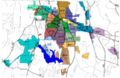
- If successful you should see the new beats/districts in the places column on the left hand side:

- And you should be able to click on them and see something like the Image Below:
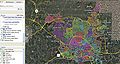
CityWide Map
(Click to enlarge)

- You now have the ability to zoom in to street level and out and click on individual Beats/Districts and see which beats cover which areas.
Wake County Sheriff Unit Numbering
- 100 units are administrative
- 200 units are investigators
- 300 units are SRO's (School Resource Officers)
- 400 units are jail transport
- 500 units are judicial services
- 600 units are A Platoon units...Patrol (regular road deputies)
- 800 units are B Platoon units...Patrol (regular road deputies)
- 900 units are STOP/IMPACT & K-9 Units (STOP are deputies that do traffic enforcement and IMPACT are Drug enforcement patrol units).
The zone map is mainly just for assignment purposes. Road deputies are assigned to a zone or zones at the beginning of their shift. They will usually be assigned calls in their zone or an adjacent zone if needed.
Wake County Sheriff Dept Maps
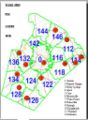
Dept Zone Layout
Dept Beat Map


Raleigh/Wake County 10 Codes/Signals
Raleigh Ten Codes

Raleigh (NC) Fire Dept. (WPCI922)
- Sta. #1 - 220 S. Dawson St. (aka State Route 50/US-70/US-401) between W. Hargett St. & W. Martin St. (KII313) (Engine 1/Engine 13/Ladder 4/Fire Invest Unit/Car 401/Car 402)
- Sta. #2 - 263 Pecan Rd. between S. Saunders St. (aka State Route 50/US-70/US-401) & Renfrow Rd. (KII313) (Engine 2/Haz-Mat 1)
- Sta. #3 - 11-13 S. East St. between New Bern Ave. & Morson St. (KII313) (Engine 3)
- Sta. #4 -
- Current Sta. - 121 Northway Ct. @ Horizon Dr. (Engine 4/Ladder 1)
- Former Sta. - 505 Jefferson St. between Glenwood Ave. & Filmore St.
- Sta. #5 - 300 Oberlin Rd. @ 1920-1922 Park Dr. (Engine 5)
- Sta. #6 -
- Current Sta. - 2601 Fairview Rd. @ Oberlin Rd. (Engine 6)
- Former Sta. - 2519 Fairview Rd. between Oberlin Rd. & St. Mary's St.
- Sta. #7 - 2100 Glascock St. @ N. Raleigh Blvd. (Squad 7/Mini-Pumper 2)
- Sta. #8 -
- Current Sta. - 5001 Western Blvd. between Pineland Cir. & Gannett St. (Engine 8/Battalion 3/Air Truck/Haz-Mat 3)
- Former Sta. - 1007 Method Rd. between Western Blvd. & Reavis Rd.
- Sta. #9 - 4465 Six Forks Rd. @ Rowan St. (Engine 9/Battalion 5)
- Sta. #10 - 2711 Sanderford Rd. between Seabrook Rd. & Elkpark Dr. (Engine 10)
- Sta. #11 - 2925 Glenridge Dr. between Highwoods Blvd. & Ward Rd. (Engine 11/Ladder 2)
- Sta. #12 -
- Current Sta. - 4302-4306 Poole Rd. (aka County Route 1007) @ 803-807 Bus Way (WNYY760) (Engine 12/Ladder 8/Battalion 2)
- Former Sta. - 3409 Poole Rd. (aka County Route 1007) between Birch Ridge Dr. & Samuel Rd.
- Sta. #14 - 4220 Lake Boone Trl. between Rexwoods Dr. & Rex Way (WNYY760) (Squad 14/Mini-Pumper 3)
- Sta. #15 - 1815 Spring Forest Rd. across from Sentinel Dr. (WNYY760) (Engine 15)
- Sta. #16 - 5225 Lead Mine Rd. between Belsay Dr. & Yorkgate Dr. (WNYY760) (Engine 16/Rescue 1)
- Sta. #17 - 4601 Pleasant Valley Rd. between Duraleigh Rd. & Grove Church Rd. (WNYY760) (Engine 17/Ladder 3)
- Sta. #18 - 8200 Morgans Way @ Creedmoor Rd. (aka State Route 50) (WNYY760) (Engine 18/Battalion 4)
- Sta. #19 - 4209 Spring Forest Rd. between Sedgewick Dr. & Somerset Springs Dr. (WNYY759) (Engine 19/Battalion 1)
- Sta. #20 - 1721 Trailwood Dr. between Main Campus Dr. & Crump Rd. (WNYY759) (Engine 20/Ladder 7)
- Sta. #21 - 2651 Southall Rd. between Eagle Trace Dr. & Skycrest Dr. (Engine 21/Swift Water Rescue 801)
- Sta. #22 -
- Current Sta. - 9350 Durant Rd. (aka County Route 2006) between Leslieshire Dr. & Hawksmoor Dr. (Engine 22/Ladder 5/Haz-Mat 4)
- Temporary Sta. - 10231 Falls of Neuse Rd. (aka County Route 2000) between Durant Rd. (aka County Route 2006) & Raven Ridge Rd. (aka County Route 2010) (The Crew Quarters sat at the following coordinates: 35.914376/-78.599710 & the Engine Bay sat at the following coordinates: 35.914405/-78.599965)
- Sta. #23 - 8312 Pinecrest Rd. between Seafarer Ct. & O'Neal Rd. (Engine 23/Ladder 9) (Sta. #23 is shared with the Durham Highway V.F.D. Sta. #2)
- Sta. #24 - 10440 Fossil Creek Ct. between Brier Creek Pkwy. & Dead End (Engine 24/Ladder 6) (Sta. #24 sits at the Dead End)
- Sta. #25 - 2740 Wakefield Crossing Dr. between Queensland Rd. & Berks Way (Engine 25/Ladder 5/Haz-Mat)
- Sta. #26 - 3929 Barwell Rd. between Barwell Park Dr. & Tomahawk Trl. (Engine 26/Ladder 8)
- Sta. #27 - 5916 Buffaloe Rd. (aka County Route 2215) between Woodchurch Ct. & Tallyhoe Dr. (Engine 27/Haz-Mat 5)
- Sta. #28 - 3500 Forestville Rd. (aka County Route 2049) between Mitchell Mill Rd. (aka County Route 2224) & Hopper St. (Engine 28/Ladder 9/Mini-Pumper 1/Air 2)
- Sta. #29 - 12117 Leesville Rd. (aka County Route 1839) @ Englehardt Dr. (Engine 29/Haz-Mat 2)
- Capital Hose Co. - 115-117 W. Morgan St. between S. McDowell St. (aka State Route 50/US-70/US-401) & S. Salisbury St. ***(NOW CLOSED)***
Wake County (NC) Fire & Amb. Dept.'s
- Angier & Black River V.F.D. Inc. - 309 N. Broad St. E. (aka County Route 1500) between W. Dora St. & E. Wimberly St.,Angier (Hartnett Co.) (Has coverage in Wake Co.)
- Apex V.F.D. (KIP936/WPMJ915) -
- Sta. #1 - 210 N. Salem St. (aka County Route 1011) between Center St. & Saunders St.,Apex (Sta. #1 is Wake Co. Dept. #4)
- Sta. #2 - 3045 New Hill Holleman Rd. (aka County Route 1127) between Stewart Rd. & Church Rd. (aka County Route 1166),New Hill (Sta. #2 is Wake Co. Dept. #40)
- Sta. #3 (HQ) - 736 Hunter St. between W. Chatham St. & Gablefield Ln.,Apex (Sta. #3 is Wake Co. Dept. #44)
- Sta. #4 - 1607-1615 E. Williams St. (aka State Route 55) between Pristine Water Dr. & Technology Dr.
- Sta. #5 - 2050 Kelly Rd. @ 6900-6908 Apex Barbecue Rd.
- Apex E.M.S. - 313-315 W. Williams St. (aka State Route 55) @ Upchurch St. ***(DISBANDED)***
- Cary F.D. (KBK537) -
- HQ - 100 N. Academy St. @ E. Cedar St.
- Sta. #1 - 1501-1503 N. Harrison Ave. between N.W. Cary Pkwy. & Livingstone Dr.
- Sta. #2 - 601 E. Chatham St. (aka County Route 1011) @ Reedy Creek Rd.
- Sta. #3 - 1807 Kildaire Farm Rd. (aka County Route 1300) between Kildaire Park Dr. & Keisler Dr.
- Sta. #4 - 1401 Old Apex Rd. (aka County Route 1011) between W. Chatham St. (aka County Route 1011) & Marilyn Cir.
- Sta. #5 - 2101 High House Rd. between Tumbled Way & Cornerstone Dr.
- Sta. #6 - 3609 Ten-Ten Rd. @ Plumtree Way
- Sta. #7 - 6900 Carpenter Fire Station Rd. (aka County Route 1624) between State Route 55 & Howard Rd. (Sta. #7 is shared w/Morrisville V.F.D. Sta. #3)
- Sta. #8 - 408 Mills Park Dr. @ Green Level Church Rd. (aka County Route 1625)
- Sta. #9 -
- Current Sta. - 1427 Walnut St. @ Nottingham Dr.
- Former Sta. - 875 S.E. Maynard Rd. (aka County Route 1415) between Cary Towne Blvd. & Village Greenway
- Cary Area E.M.S. - 107 Medcon Ct. between Kildaire Farm Rd. (aka County Route 1300) & Kylie Savannah Ct.
- Creedmoor V.F.D. - 101 S. Elm St. @ W. Lyon St.,Creedmoor (Granville Co.) (Creedmoor V.F.D. has jurisdiction in Wake Co.)
- Durham F.D. -
- HQ - 2008 E. Club Blvd. between Camden Ave. & Jones Park Dr.,Durham (Durham Co.)
- Sta. #1 -
- Current Sta. - 139 E. Morgan St. (aka Business US-70) @ Cleveland St.,Durham (Durham Co.)
- Former Sta. - 102 City Hall Plaza @ N. Mangum St. (aka Business US-15/Business US-501),Durham (Durham Co.)
- Sta. #2 - 1001 Ninth St. @ W. Knox St.,Durham (Durham Co.)
- Sta. #3 -
- Current Sta. - 822 N. Miami Blvd. (aka Business US-70) between Holloway St. (aka State Route 98) & Liberty St.,Durham (Durham Co.)
- Former Sta. - 103 S. Driver St. @ E. Main St.,Durham (Durham Co.)
- Sta. #4 -
- Current Sta. - 1818 Riddle Rd. between Apex Hwy. (aka State Route 55) & S. Alston Ave.,Durham (Durham Co.)
- Former Sta. - 2010 Fayetteville St. (aka County Route 1118) @ Pekoe Ave.,Durham (Durham Co.)
- Sta. #5 - 2212 Chapel Hill Rd. @ Ward St.,Durham (Durham Co.)
- Sta. #6 - 3700 Swarthmore Rd. @ Hope Valley Rd. (aka State Route 751),Durham (Durham Co.)
- Sta. #7 - 3919-3923 N. Duke St. (aka US-501 Bypass) between Holt School Rd. & Monk Rd.,Durham (Durham Co.)
- Sta. #8 -
- Current Sta. - 225 Lick Creek Ln. @ Wake Forest Hwy. (aka US-98),Durham (Durham Co.)
- Former Sta. - 2725 Holloway St. (aka US-98) between S. Woodcrest St. & Rochelle St.,Durham (Durham Co.) ***(Now Durham Co. E.M.S. Sta. #4)***
- Sta. #9 -
- Current Sta. - 1648 Midland Terr. @ Camden Ave.,Durham (Durham Co.)
- Former Sta. - 2012 E. Club Blvd. @ Camden Ave.,Durham (Durham Co.)
- Sta. #10 - 1805 Cole Mill Rd. (aka County Route 1401) between Kimball Dr. & Colewood Dr.,Durham (Durham Co.)
- Sta. #11 - 2800 W. Cornwallis Rd. across from Ridge Rd.,Durham (Durham Co.)
- Sta. #12 - 1230 Carpenter Fletcher Rd. @ North Bend Dr.,Durham (Durham Co.)
- Sta. #13 - 2901 S. Miami Blvd. (aka County Route 1959) between Presidential Dr. & Brassfield Rd.,Durham (Durham Co.) (Sta. #13 has coverage in Wake Co.)
- Sta. #14 - 1327 Umstead Rd. (aka County Route 1449) across from Bivins Rd. (aka County Route 1453),Durham (Durham Co.)
- Sta. #15 - 2060 Torredge Rd. between Snow Hill Rd. & Dead End,Durham (Durham Co.)
- Sta. #16 - 6303 Farrington Rd. across from Dunbrook Dr.,Durham (Durham Co.) (Sta. #16 has coverage in Chatham Co.)
- Sta. #17 - 5503 Leesville Rd. (aka County Route 1975) across from Adventure Trl.,Durham (Durham Co.)
- Sta. #18 - 1409 Seaton Rd. between Revere Rd. & McCormick Rd.,Durham (Durham Co.) (Sta. #18 was formerly Parkwood V.F.D. Sta. #1 & Durham Co. Fire/Rescue Sta. #83)
- Sta. #19 - 4716 Old Page Rd. between S. Miami Blvd. (aka County Route 1959) & Central Park Dr.,Durham (Durham Co.) (Sta. #19 was formerly Parkwood V.F.D. Sta. #3 & Durham Co. Fire/Rescue Sta. #81)
- Old Training Tower - 501 Washington St. between W. Geer St. & W. Corporation St.,Durham (Durham Co.)
- Durham Highway V.F.D. -
- Sta. #1 (HQ) - 11905 Norwood Rd. (aka County Route 1834) between N. Hawthorne Way & Old Holiday Rd.,Raleigh (Sta. #1 is Wake Co. Dept. # 16)
- Sta. #2 - 8312 Pinecrest Rd. between Seafarer Ct. & O'Neal Rd.,Raleigh (Sta. #2 is shared w/Raleigh F.D. Sta. #23)
- Eastern Wake V.F.D. -
- Eastern Wake E.M.S. -
- HQ -
- Current Sta. - 6021 Taylor Rd. (aka County Route 2502) between Wendell Falls Pkwy. & Douglas Falls Dr.,Wendell (HQ is shared w/Wendell F.D. Sta. #3)
- Former Sta. - 401 E. Third St. between N. Selma Rd. (aka State Route 231) & Walnut St,Wendell
- Clifton Rd. Sta. - 4828 Clifton Rd. (aka County Route 2511) @ Poole Rd. (aka County Route 1007),Knightdale (Clifton Rd. Sta. is shared w/Eastern Wake V.F.D. Sta. #1 & houses E.M.S. 60)
- Knightdale Sta. - 971 Steeple Square Ct. between N. Smithfield Rd. (aka County Route 2233) & Dead End,Knightdale (Knightdale Sta. is shared w/Knightdale V.F.D. Sta. #1 & houses E.M.S. 61)
- Wendell Sta. - 3001 Wendell Blvd. (aka US-64) between Hanor Ln. & Industrial Dr.,Wendell (Houses E.M.S. 62 & E.M.S. 67)
- Zebulon Sta. - 131 E. Vance St. between N. Arendell Ave. (aka State Route 96) & N. Poplar St.,Zebulon (Formerly Zebulon Area Rescue/Squad Inc. with a callsign of KXG896) (Zebulon Sta. houses E.M.S. 63)
- Rolesville Sta. - 204 E. Young St. (aka County Route 1003) between Pulley St. & Church St.,Rolesville (Houses E.M.S. 64)
- Bethany Church Sta. - 6529 Bethany Church Rd. between Bell Estate Dr. & Davistown Rd. (aka County Route 2322),Wendell (Shares Sta. w/Wendell F.D Sta. #2 and houses E.M.S. 68 & E.M.S. 69)
- HQ -
- Fairview V.F.D. -
- Sta. #1 (HQ) - 4501 Ten-Ten Rd. across from Orchard Knoll Dr.,Apex (Sta. #1 is Wake Co. Dept. #20)
- Sta. #2 - 7401 Ten-Ten Rd. between Lake Wheeler Rd. (aka County Route 1375) & Laughton Woods Ct.,Apex (Sta. #2 is Wake Co. Dept. #34)
- Fuquay-Varina Area Rescue - 128 S. Fuquay Ave. between E. Academy St. (aka County Route 1107) & Raleigh St.,Fuquay-Varina (WNXU415) ***(DISBANDED)***
- Fuquay-Varina V.F.D. -
- Sta. #1 (HQ) - 301 S. Fuquay Ave. @ E. Vance St.,Fuquay-Varina (Bays face E. Vance St. & Sta. #1 is Wake Co. Dept. #7)
- Sta. #2 - 5617 Hilltop Rd. across from Wrenn St.,Fuquay-Varina (Sta. #2 is Wake Co. Dept. #33)
- Sta. #3 - 2474 Bud Lipscomb Rd. between Old Stage Rd. (aka County Route 1006) & Old Store Rd.,Fuquay-Varina (Sta. #3 is Wake Co. Dept. #45)
- Garner V.F.D. -
- Admin. -
- Current - 914 Seventh Ave. between Forest Hills Dr. & Aversboro Rd.
- Former - 120 E. Main St. between Rand Mill Rd. & Griffin St.
- Sta. #1 -
- Current Sta. - 503 W. Main St. @ Benson Rd. (aka State Route 50) (Bays face Benson Rd. & Sta. #1 is Wake Co. Dept. #8)
- Former Sta. - 110-112 Pearl St. between W. Main St. & Parker St.
- Sta. #2 - 9115 Sauls Rd. (aka County Route 2727) @ Community Garden Rd.,Raleigh (Sta. #2 is Wake Co. Dept. #18)
- Sta. #3 - 1695 Timber Dr. @ Vandora Springs Rd. (aka County Route 2711) (Bays face Vandora Springs Rd. & Sta. #3 is Wake Co. Dept. #41)
- Sta. #4 - 125 Spaceway Ct. between Raynor Rd. (aka County Route 2555) & Dead End
- Admin. -
- Garner Volunteer Rescue/Squad - 990 Vandora Springs Rd. (aka County Route 2711) @ Foxwood Dr. (KYF345) ***(DISBANDED)***
- Holly Springs F.D. (WPLE874) -
- Sta. #1 (HQ) - 700 Flint Point Ln. @ Blue Fin Way (Sta. #1 is Wake Co. Dept. #37)
- Sta. #2 - 1140 Avent Ferry Rd. @ Logging Rd. (Sta. #2 is Wake Co. Dept. #14)
- Sta. #3 - 4108-4112 Friendship Rd. between Woods Creek Rd. & Holly Springs New Hill Rd. (aka County Route 1152),Apex (Sta. #3 is Wake Co. Dept. #46)
- Hopkins Rural V.F.D. - 8929-8933 Fowler Rd. between Hopkins Chapel Rd. & Hopkins Way,Zebulon (Hopkins Rural V.F.D. is Wake Co. Dept. #22)
- Knightdale V.F.D. -
- Sta. #1 (HQ) - 967 Steeple Square Ct. between N. Smithfield Rd. (aka County Route 2233) & Dead End (Sta. #1 is Wake Co. Dept. #13)
- Sta. #2 - 306 Robertson St. (aka County Route 2500) between Keith St. & Mailman Rd. (Sta. #2 is shared w/Knightdale Public Works)
- Morrisville V.F.D. -
- Sta. #1 (HQ) -
- Current Sta. - 200 Town Hall Dr. between Morrisville Carpenter Rd. & Carolina St. (Sta. #1 is Wake Co. Dept. #23)
- Former Sta. - 100 Morrisville Carpenter Rd. @ Page St. (Bays face the railroad tracks)
- Sta. #2 - 10628-10632 Chapel Hill Rd. (aka State Route 54) between McCrimmon Pkwy. & Perimeter Park Dr. (Sta. #2 is Wake Co. Dept. #42)
- Sta. #3 -
- Current Sta. - 6900 Carpenter Fire Station Rd. (aka County Route 1624) between State Route 55 & Howard Rd.,Cary (Sta. #3 is shared w/Cary F.D. Sta. #7 and is Wake Co. Dept. #24)
- Former Sta. - 6804 Carpenter Fire Station Rd. (aka County Route 1624) between State Route 55 & Howard Rd.,Cary
- Sta. #1 (HQ) -
- North State Medical Transport (WQAX350) - 1240 Corporation Pkwy. between New Bern Ave. (aka US-64) & Commerce Park Dr.,Raleigh
- Northern Wake V.F.D. -
- Sta. #1 (HQ) - 11713 Six Forks Rd. between Possum Track Rd. (aka County Route 2002) between Norwood Rd. (aka County Route 1834),Raleigh (Formerly Bay Leaf V.F.D. Sta. #1 with a callsign of KCR979) (Sta. #1 is Wake Co. Dept. #25)
- Sta. #2 - 7045 Stony Hill Rd. between Durham Rd. (aka State Route 98) & Keith Rd. (aka County Route 1921),Wake Forest (Formerly Stony Hill Rural V.F.D. Sta. #1) (Sta. #2 is Wake Co. Dept. #26)
- Sta. #3 - 13116 Norwood Rd. (aka County Route 1834) across from Norwood Oaks Dr.,Raleigh (Formerly Bay Leaf V.F.D. Sta. #2) (Sta. #3 is Wake Co. Dept. #36)
- Sta. #4 - 15633 New Light Rd. across from Purnell Rd. (aka County Route 1909),Wake Forest (Formerly Stony Hill Rural V.F.D. Sta. #2) (Sta. #4 is Wake Co. Dept. #39)
- Sta. #5 - 1431 Lynn Rd. between Lead Mine Rd. & Middleboro Dr.,Raleigh (Formerly Bay Leaf V.F.D. Sta. #3 with a callsign of KIP933) (Sta. #5 is Wake Co. Dept. #12)
- Raleigh-Durham Int. Airport Authority Crash/Fire/Rescue - 1050 Rescue Ct. off of N. Ramp Dr.,R.D.U. Airport (Sta. sits at the following coordinates: 35.880824/-78.787180 and is Wake Co. Dept. #30)
- Rex U.N.C. Healthcare Ambulance (KYG692) - 2701 Blue Ridge Rd. @ Forest View Rd.,Raleigh (The Amb.'s sit in a parking lot along Forest View Rd. between Blue Ridge Rd. & Lake Dr.)
- Rolesville Rural V.F.D. - 104 E. Young St. (aka County Route 1003) between S. Main St. (aka US-401) & Pulley St.,Rolesville (Rolesville Rural V.F.D. is Wake Co. Dept. #15)
- REDS Team Technical Rescue (WQDN896) - 990 Vandora Springs Rd. (aka County Route 2711) @ Foxwood Dr.,Garner (Sta. formerly housed Garner Volunteer Rescue/Squad)
- Swift Creek V.F.D. - 5825 Tryon Rd. (aka County Route 1009/County Route 1152) between Holly Springs Rd. (aka County Route 1152) & Jones Franklin Rd.,Cary (Swift Creek V.F.D. is Wake Co. Dept. #27)
- Wake Co. E.M.S. -
- Sta. #1 (HQ) - 330 S. McDowell St. (aka State Route 50/US-70) @ 110 W. Davie St.,Raleigh (Bays face W. Davie St.)
- Sta. #2 - 2020 Noble Rd. between Pine Dr. & Avery Dr.,Raleigh
- Sta. #3 - 5305 Six Forks Rd. between Snelling Rd. & Windel Dr.,Raleigh
- Sta. #4 - 4017 District Dr. between Blue Ridge Rd. & Gold Star Dr.,Raleigh
- Sta. #5 - 4704 Hargrove Rd. between Spring Forest Rd. & E. Millbrook Rd.,Raleigh
- Sta. #6 - 1015 National Guard Dr. between Navigation Ln. & Haleys Branch Rd.,Raleigh (Sta. #6 sits at the following coordinates: 35.854277/-78.793167)
- Sta. #7 - 2910 Kidd Rd. between Donald Ross Dr. & Swinburne St.,Raleigh
- Sta. #8 - 1361 Varsity Dr. between Western Blvd. & Fraternity Ct.,Raleigh
- Sta. #9 - 301 S. Fuquay Ave. @ E. Vance St.,Fuquay-Varina (Sta. #9 is shared w/Fuquay-Varina V.F.D. Sta. #1)
- Sta. #10 - 706 S. Franklin St. between E. Holding Ave. & Yellow Poplar Ave.,Wake Forest
- Sta. #12 - 7045 Stony Hill Rd. between Durham Rd. (aka State Route 98) & Keith Rd. (aka County Route 1921),Wake Forest (Sta. #12 is shared w/Northern Wake V.F.D. Sta. #2)
- Sta. #14 - 5617 Hilltop Rd. across from Wrenn St.,Fuquay-Varina (Sta. #14 is shared w/Fuquay-Varina V.F.D. Sta. #2)
- Sta. #15 - 10000 Durant Rd. (aka County Route 2006) between Deerland Grove Dr. & Camp Durant Rd.,Raleigh (Sta. #15 cannot be seen from the road and sits at the following coordinates: 35.902356/-78.580678)
- Sta. #16 - 9115 Sauls Rd. (aka County Route 2727) @ Community Garden Rd.,Raleigh (Sta. #16 is shared w/Garner V.F.D. Sta. #2)
- Sta. #17 - 700 Flint Point Ln. @ Blue Fin Way,Holly Springs (Sta. #17 is shared w/Holly Springs F.D. Sta. #1)
- Sta. #18 - 1695 Timber Dr. @ Vandora Springs Rd. (aka County Route 2711),Garner (Sta. #18 is shared w/Garner V.F.D. Sta. #3)
- Sta. #19 - 125 Spaceway Ct. between Raynor Rd. (aka County Route 2555) & Dead End,Garner (Sta. #19 is shared w/Garner V.F.D. Sta. #4)
- Wake Forest F.D. -
- Sta. #1 -
- Current Sta. - 420 Elm Ave. @ S. Franklin St. (Sta. #1 is Wake Co. Dept. #6)
- Former Sta. -
- 221 Brooks St. between E. Jones Ave. & E. Owen Ave.
- 352 S. White St. @ Elm Ave.
- Sta. #2 - 9925 Ligon Mill Rd. (aka County Route 2044) between Forest Lynks Dr. & Pompeii Pl. (Sta. #2 is Wake Co. Dept. #43)
- Sta. #3 - 1412 Forestville Rd. (aka County Route 2049) between Foxwild Ln. & Pine Valley Dr. (Sta. #3 is Wake Co. Dept. #47)
- Sta. #4 - 1505-1509 Jenkins Rd. across from Fullard Rd.
- Sta. #5 - 11908 Holmes Hollow Rd. (aka County Route 2000) between Fonville Rd. (aka County Route 2001) & Old Falls of Neuse Rd. (Sta. #5 is Wake Co. Dept. #21 and is the former Falls V.F.D. It also has an address of 11908 Falls of Neuse Rd.)
- Sta. #1 -
- Wake-New Hope F.D. -
- Sta. #1 - 4415 St. James Church Rd. between Louisburg Rd. (aka US-401) & Hopson Dr.,Raleigh (Sta. #1 is Wake Co. Dept. #28)
- Sta. #2 (HQ) - 4909-4913 Watkins Rd. between Old Milburnie Rd. (aka County Route 2217) & Dream Land Rd.,Wendell (Sta. #2 is Wake Co. Dept. #31)
- Wendell F.D. -
- Sta. #1 (HQ) - 2960 Wendell Blvd. (aka US-64) between Liles Dean Rd. & Industrial Dr. (Sta. #1 is Wake Co. Dept. #11)
- Sta. #2 - 6529 Bethany Church Rd. between Davistown Rd. (aka County Route 2322) & Bell Estate Dr. (Sta. #2 is Wake Co. Dept. #32 and is shared w/Eastern Wake E.M.S.)
- Sta. #3 - 6021 Taylor Rd. (aka County Route 2502) between Wendell Falls Pkwy. & Douglas Falls Dr. (Sta. #3 is shared w/Eastern Wake E.M.S.)
- Western Wake Fire/Rescue - 4021 District Dr. between Blue Ridge Rd. & Gold Star Dr.,Raleigh
- Zebulon F.D. - 113 E. Vance St. between N. Arendell Ave. (aka State Route 96) & N. Poplar St.
Related Links
- Wake County (NC) EMS 800Mhz Viper System Procedures
- Wake County (NC) Fire Brevity Codes
- Wake County (NC) Tone-Out List
- Wake County (NC) Raleigh EMS Medical Priority Codes
- Wake County (NC) Raleigh PD Monitoring Guide
- Wake County NC EMS Station IDs
- Raleigh Durham International Airport (RDU) Wake County (NC)
Return to DB page: Wake County (NC)
Return to Wiki page: North Carolina Counties