Difference between revisions of "Wake County (NC)"
From The RadioReference Wiki
| Line 56: | Line 56: | ||
*[[media:WakeCoTenCodesSignals.pdf|Wake County Ten Codes/Signals]] | *[[media:WakeCoTenCodesSignals.pdf|Wake County Ten Codes/Signals]] | ||
| − | ==Raleigh (NC) Fire Dept.== | + | ==Raleigh (NC) Fire Dept. ({{Callsign|WPCI922}})== |
| + | |||
| + | * ''Sta. #1'' - 220 S. Dawson St. (aka State Route 50/US-70/US-401) between W. Hargett St. & W. Martin St. '''({{Callsign|KII313}})''' (Engine 1/Engine 13/Ladder 4/Fire Invest Unit/Car 401/Car 402) | ||
| + | * ''Sta. #2'' - 263 Pecan Rd. between S. Saunders St. (aka State Route 50/US-70/US-401) & Renfrow Rd. '''({{Callsign|KII313}})''' (Engine 2/Haz-Mat 1) | ||
| + | * ''Sta. #3'' - 11-13 S. East St. between New Bern Ave. & Morson St. '''({{Callsign|KII313}})''' (Engine 3) | ||
| + | * ''Sta. #4'' - | ||
| + | ** Current Sta. - 121 Northway Ct. @ Horizon Dr. (Engine 4/Ladder 1) | ||
| + | ** Former Sta. - 505 Jefferson St. between Glenwood Ave. & Filmore St. | ||
| + | * ''Sta. #5'' - 300 Oberlin Rd. @ 1920-1922 Park Dr. (Engine 5) | ||
| + | * ''Sta. #6'' - | ||
| + | ** Current Sta. - 2601 Fairview Rd. @ Oberlin Rd. (Engine 6) | ||
| + | ** Former Sta. - 2519 Fairview Rd. between Oberlin Rd. & St. Mary's St. | ||
| + | * ''Sta. #7'' - 2100 Glascock St. @ N. Raleigh Blvd. (Squad 7/Mini-Pumper 2) | ||
| + | * ''Sta. #8'' - | ||
| + | ** Current Sta. - 5001 Western Blvd. between Pineland Cir. & Gannett St. (Engine 8/Battalion 3/Air Truck/Haz-Mat 3) | ||
| + | ** Former Sta. - 1007 Method Rd. between Western Blvd. & Reavis Rd. | ||
| + | * ''Sta. #9'' - 4465 Six Forks Rd. @ Rowan St. (Engine 9/Battalion 5) | ||
| + | * ''Sta. #10'' - 2711 Sanderford Rd. between Seabrook Rd. & Elkpark Dr. (Engine 10) | ||
| + | * ''Sta. #11'' - 2925 Glenridge Dr. between Highwoods Blvd. & Ward Rd. (Engine 11/Ladder 2) | ||
| + | * ''Sta. #12'' - | ||
| + | ** Current Sta. - 4302-4306 Poole Rd. (aka County Route 1007) @ 803-807 Bus Way '''({{Callsign|WNYY760}})''' (Engine 12/Ladder 8/Battalion 2) | ||
| + | ** Former Sta. - 3409 Poole Rd. (aka County Route 1007) between Birch Ridge Dr. & Samuel Rd. | ||
| + | * ''Sta. #14'' - 4220 Lake Boone Trl. between Rexwoods Dr. & Rex Way '''({{Callsign|WNYY760}})''' (Squad 14/Mini-Pumper 3) | ||
| + | * ''Sta. #15'' - 1815 Spring Forest Rd. across from Sentinel Dr. '''({{Callsign|WNYY760}})''' (Engine 15) | ||
| + | * ''Sta. #16'' - 5225 Lead Mine Rd. between Belsay Dr. & Yorkgate Dr. '''({{Callsign|WNYY760}})''' (Engine 16/Rescue 1) | ||
| + | * ''Sta. #17'' - 4601 Pleasant Valley Rd. between Duraleigh Rd. & Grove Church Rd. '''({{Callsign|WNYY760}})''' (Engine 17/Ladder 3) | ||
| + | * ''Sta. #18'' - 8200 Morgans Way @ Creedmoor Rd. (aka State Route 50) '''({{Callsign|WNYY760}})''' (Engine 18/Battalion 4) | ||
| + | * ''Sta. #19'' - 4209 Spring Forest Rd. between Sedgewick Dr. & Somerset Springs Dr. '''(Callsign|WNYY759}})''' (Engine 19/Battalion 1) | ||
| + | * ''Sta. #20'' - 1721 Trailwood Dr. between Main Campus Dr. & Crump Rd. '''({{Callsign|WNYY759}})''' (Engine 20/Ladder 7) | ||
| + | * ''Sta. #21'' - 2651 Southall Rd. between Eagle Trace Dr. & Skycrest Dr. (Engine 21/Swift Water Rescue 801) | ||
| + | * ''Sta. #22'' - | ||
| + | ** Current Sta. - 9350 Durant Rd. (aka County Route 2006) between Leslieshire Dr. & Hawksmoor Dr. (Engine 22/Ladder 5/Haz-Mat 4) | ||
| + | ** Temporary Sta. - 10231 Falls of Neuse Rd. (aka County Route 2000) between Durant Rd. (aka County Route 2006) & Raven Ridge Rd. (aka County Route 2010) (The Crew Quarters sat at the following coordinates: 35.914376/-78.599710 & the Engine Bay sat at the following coordinates: 35.914405/-78.599965) | ||
| + | * ''Sta. #23'' - 8312 Pinecrest Rd. between Seafarer Ct. & O'Neal Rd. (Engine 23/Ladder 9) (Sta. #23 is shared with the Durham Highway V.F.D. Sta. #2) | ||
| + | * ''Sta. #24'' - 10440 Fossil Creek Ct. between Brier Creek Pkwy. & Dead End (Engine 24/Ladder 6) (Sta. #24 sits at the Dead End) | ||
| + | * ''Sta. #25'' - 2740 Wakefield Crossing Dr. between Queensland Rd. & Berks Way (Engine 25/Ladder 5/Haz-Mat) | ||
| + | * ''Sta. #26'' - 3929 Barwell Rd. between Barwell Park Dr. & Tomahawk Trl. (Engine 26/Ladder 8) | ||
| + | * ''Sta. #27'' - 5916 Buffaloe Rd. (aka County Route 2215) between Woodchurch Ct. & Tallyhoe Dr. (Engine 27/Haz-Mat 5) | ||
| + | * ''Sta. #28'' - 3500 Forestville Rd. (aka County Route 2049) between Mitchell Mill Rd. (aka County Route 2224) & Hopper St. (Engine 28/Ladder 9/Mini-Pumper 1/Air 2) | ||
| + | * ''Sta. #29'' - 12117 Leesville Rd. (aka County Route 1839) @ Englehardt Dr. (Engine 29/Haz-Mat 2) | ||
| + | * ''Capital Hose Co.'' - 115-117 W. Morgan St. between S. McDowell St. (aka State Route 50/US-70/US-401) & S. Salisbury St. '''''***(NOW CLOSED)***''''' | ||
==Related Links== | ==Related Links== | ||
Revision as of 00:49, 29 April 2020
Contents
Using Google Earth to view Raleigh Police Department Districts/Beats
Google Earth can now be used to view every Raleigh PD Beat & District. It is Very easy to setup:
- Go to Google Earth and download Google Earth and install it for your operating system. It is available for most operating systems.
- Download this zip file from RR.com: RPDKMLFiles.Zip
- Unzip and Extract the 2 files in the RPDKMLFiles.zip file you just downloaded.
- The 2 Files you should now have are named:
- New Beats.kml
- New District.kml
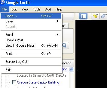
- Start up Google Earth and Select "File" then "Open" as shown below:
- Select both of the ".kml" files you just saved a few minutes ago and Google Earth
should import them.
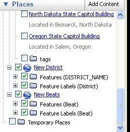
- If successful you should see the new beats/districts in the places column on the left hand side:
- And you should be able to click on them and see something like the Image Below:
- You now have the ability to zoom in to street level and out and click on individual Beats/Districts and see which beats cover which areas.
Wake County Sheriff Unit Numbering
- 100 units are administrative
- 200 units are investigators
- 300 units are SRO's (School Resource Officers)
- 400 units are jail transport
- 500 units are judicial services
- 600 units are A Platoon units...Patrol (regular road deputies)
- 800 units are B Platoon units...Patrol (regular road deputies)
- 900 units are STOP/IMPACT & K-9 Units (STOP are deputies that do traffic enforcement and IMPACT are Drug enforcement patrol units).
The zone map is mainly just for assignment purposes. Road deputies are assigned to a zone or zones at the beginning of their shift. They will usually be assigned calls in their zone or an adjacent zone if needed.
Wake County Sheriff Dept Maps
Raleigh/Wake County 10 Codes/Signals
Raleigh (NC) Fire Dept. (WPCI922)
- Sta. #1 - 220 S. Dawson St. (aka State Route 50/US-70/US-401) between W. Hargett St. & W. Martin St. (KII313) (Engine 1/Engine 13/Ladder 4/Fire Invest Unit/Car 401/Car 402)
- Sta. #2 - 263 Pecan Rd. between S. Saunders St. (aka State Route 50/US-70/US-401) & Renfrow Rd. (KII313) (Engine 2/Haz-Mat 1)
- Sta. #3 - 11-13 S. East St. between New Bern Ave. & Morson St. (KII313) (Engine 3)
- Sta. #4 -
- Current Sta. - 121 Northway Ct. @ Horizon Dr. (Engine 4/Ladder 1)
- Former Sta. - 505 Jefferson St. between Glenwood Ave. & Filmore St.
- Sta. #5 - 300 Oberlin Rd. @ 1920-1922 Park Dr. (Engine 5)
- Sta. #6 -
- Current Sta. - 2601 Fairview Rd. @ Oberlin Rd. (Engine 6)
- Former Sta. - 2519 Fairview Rd. between Oberlin Rd. & St. Mary's St.
- Sta. #7 - 2100 Glascock St. @ N. Raleigh Blvd. (Squad 7/Mini-Pumper 2)
- Sta. #8 -
- Current Sta. - 5001 Western Blvd. between Pineland Cir. & Gannett St. (Engine 8/Battalion 3/Air Truck/Haz-Mat 3)
- Former Sta. - 1007 Method Rd. between Western Blvd. & Reavis Rd.
- Sta. #9 - 4465 Six Forks Rd. @ Rowan St. (Engine 9/Battalion 5)
- Sta. #10 - 2711 Sanderford Rd. between Seabrook Rd. & Elkpark Dr. (Engine 10)
- Sta. #11 - 2925 Glenridge Dr. between Highwoods Blvd. & Ward Rd. (Engine 11/Ladder 2)
- Sta. #12 -
- Current Sta. - 4302-4306 Poole Rd. (aka County Route 1007) @ 803-807 Bus Way (WNYY760) (Engine 12/Ladder 8/Battalion 2)
- Former Sta. - 3409 Poole Rd. (aka County Route 1007) between Birch Ridge Dr. & Samuel Rd.
- Sta. #14 - 4220 Lake Boone Trl. between Rexwoods Dr. & Rex Way (WNYY760) (Squad 14/Mini-Pumper 3)
- Sta. #15 - 1815 Spring Forest Rd. across from Sentinel Dr. (WNYY760) (Engine 15)
- Sta. #16 - 5225 Lead Mine Rd. between Belsay Dr. & Yorkgate Dr. (WNYY760) (Engine 16/Rescue 1)
- Sta. #17 - 4601 Pleasant Valley Rd. between Duraleigh Rd. & Grove Church Rd. (WNYY760) (Engine 17/Ladder 3)
- Sta. #18 - 8200 Morgans Way @ Creedmoor Rd. (aka State Route 50) (WNYY760) (Engine 18/Battalion 4)
- Sta. #19 - 4209 Spring Forest Rd. between Sedgewick Dr. & Somerset Springs Dr. (Callsign|WNYY759}}) (Engine 19/Battalion 1)
- Sta. #20 - 1721 Trailwood Dr. between Main Campus Dr. & Crump Rd. (WNYY759) (Engine 20/Ladder 7)
- Sta. #21 - 2651 Southall Rd. between Eagle Trace Dr. & Skycrest Dr. (Engine 21/Swift Water Rescue 801)
- Sta. #22 -
- Current Sta. - 9350 Durant Rd. (aka County Route 2006) between Leslieshire Dr. & Hawksmoor Dr. (Engine 22/Ladder 5/Haz-Mat 4)
- Temporary Sta. - 10231 Falls of Neuse Rd. (aka County Route 2000) between Durant Rd. (aka County Route 2006) & Raven Ridge Rd. (aka County Route 2010) (The Crew Quarters sat at the following coordinates: 35.914376/-78.599710 & the Engine Bay sat at the following coordinates: 35.914405/-78.599965)
- Sta. #23 - 8312 Pinecrest Rd. between Seafarer Ct. & O'Neal Rd. (Engine 23/Ladder 9) (Sta. #23 is shared with the Durham Highway V.F.D. Sta. #2)
- Sta. #24 - 10440 Fossil Creek Ct. between Brier Creek Pkwy. & Dead End (Engine 24/Ladder 6) (Sta. #24 sits at the Dead End)
- Sta. #25 - 2740 Wakefield Crossing Dr. between Queensland Rd. & Berks Way (Engine 25/Ladder 5/Haz-Mat)
- Sta. #26 - 3929 Barwell Rd. between Barwell Park Dr. & Tomahawk Trl. (Engine 26/Ladder 8)
- Sta. #27 - 5916 Buffaloe Rd. (aka County Route 2215) between Woodchurch Ct. & Tallyhoe Dr. (Engine 27/Haz-Mat 5)
- Sta. #28 - 3500 Forestville Rd. (aka County Route 2049) between Mitchell Mill Rd. (aka County Route 2224) & Hopper St. (Engine 28/Ladder 9/Mini-Pumper 1/Air 2)
- Sta. #29 - 12117 Leesville Rd. (aka County Route 1839) @ Englehardt Dr. (Engine 29/Haz-Mat 2)
- Capital Hose Co. - 115-117 W. Morgan St. between S. McDowell St. (aka State Route 50/US-70/US-401) & S. Salisbury St. ***(NOW CLOSED)***
Related Links
- Wake County (NC) EMS 800Mhz Viper System Procedures
- Wake County (NC) Fire Brevity Codes
- Wake County (NC) Tone-Out List
- Wake County (NC) Raleigh EMS Medical Priority Codes
- Wake County (NC) Raleigh PD Monitoring Guide
- Wake County NC EMS Station IDs
- Raleigh Durham International Airport (RDU) Wake County (NC)
Return to DB page: Wake County (NC)
Return to Wiki page: North Carolina Counties


