300px-Montgomerytownships.PNG
From The RadioReference Wiki
No higher resolution available.
300px-Montgomerytownships.PNG (300 × 319 pixels, file size: 100 KB, MIME type: image/png)
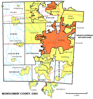
Map of Montgomery County, Ohio townships, cities and villages.
File history
Click on a date/time to view the file as it appeared at that time.
| Date/Time | Thumbnail | Dimensions | User | Comment | |
|---|---|---|---|---|---|
| current | 19:15, 11 October 2009 | | 300 × 319 (100 KB) | Radioscan (talk | contribs) | Map of Montgomery County, Ohio townships, cities and villages. |
- You cannot overwrite this file.
File usage
The following page uses this file: