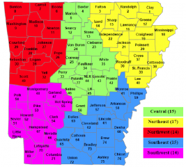
ADEM Emergency Management Area Map.png
From The RadioReference Wiki

Size of this preview: 666 × 599 pixels. Other resolutions: 267 × 240 pixels | 740 × 666 pixels.
Original file (740 × 666 pixels, file size: 147 KB, MIME type: image/png)
Summary
Arkansas ADEM Emergency Management Area Map 2021
File history
Click on a date/time to view the file as it appeared at that time.
| Date/Time | Thumbnail | Dimensions | User | Comment | |
|---|---|---|---|---|---|
| current | 14:03, 13 January 2024 | | 740 × 666 (147 KB) | Starcom21 (talk | contribs) | Arkansas ADEM Emergency Management Area Map 2021 |
- You cannot overwrite this file.
File usage
The following page uses this file: