Difference between revisions of "Individual NM DTRS Sites/Tesuque"
From The RadioReference Wiki
| Line 12: | Line 12: | ||
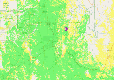
===Approximate Coverage Maps=== | ===Approximate Coverage Maps=== | ||
| − | [[File: | + | [[File:SantaFe.jpg|400px|thumb|left]] |
| − | [[File: | + | [[File:SantaFe-zoomed.jpg|400px|thumb|left]] |
[[http://wiki.radioreference.com/images/8/8e/Tesuque.jpg Click here for full resolution]] | [[http://wiki.radioreference.com/images/8/8e/Tesuque.jpg Click here for full resolution]] | ||
Revision as of 03:11, 8 September 2021
Tesuque (1-003)
- Frequencies:
| Site | Name | Freqs | |||||
|---|---|---|---|---|---|---|---|
| 003 (3) | Tesuque Peak | 769.906250c | 770.193750c | 770.468750c | 773.568750c | 774.568750 | 774.818750 |
- County Location: Santa Fe
- Counties Covered: Santa Fe County, Sandoval County
- Agencies Frequently Affiliating: NMSP
- Denied Affiliations:
- Other Notes: None
- Please click on the site name (in blue) in the database listing for more information
Approximate Coverage Maps
File:SantaFe-zoomed.jpg
400px
[Click here for full resolution]
Back to New Mexico DTRS site list
Refresh this page from the latest database entry
