Difference between revisions of "Individual CO DTRS Sites/Cedar Heights"
From The RadioReference Wiki
Soundchaser (talk | contribs) (Created page with "== Cedar Heights (4-024)== *'''County location:''' El Paso *'''Counties covered:''' El Paso *'''Other notes:''' *'''Frequencies:''...") |
Soundchaser (talk | contribs) m |
||
| Line 2: | Line 2: | ||
*'''County location:''' [[El_Paso_County_(CO)|El Paso]] | *'''County location:''' [[El_Paso_County_(CO)|El Paso]] | ||
*'''Counties covered:''' [[El_Paso_County_(CO)|El Paso]] | *'''Counties covered:''' [[El_Paso_County_(CO)|El Paso]] | ||
| − | *'''Other notes:''' | + | *'''Other notes:''' Coverage map assumes an omnidirectional antenna. |
*'''Frequencies:''' | *'''Frequencies:''' | ||
<site>329|15620</site> | <site>329|15620</site> | ||
| Line 10: | Line 10: | ||
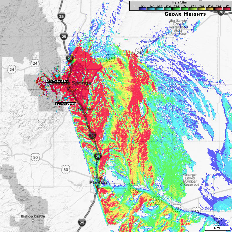
===Approximate Coverage Map=== | ===Approximate Coverage Map=== | ||
[[File:Cedarheights.jpg|400px|thumb|left]] | [[File:Cedarheights.jpg|400px|thumb|left]] | ||
| − | [[http://wiki.radioreference.com/images/ | + | [[http://wiki.radioreference.com/images/5/59/Cedarheights.jpg Click here for full resolution]] |
[[Information on Coverage Maps]] | [[Information on Coverage Maps]] | ||
Revision as of 19:03, 15 April 2011
Cedar Heights (4-024)
- County location: El Paso
- Counties covered: El Paso
- Other notes: Coverage map assumes an omnidirectional antenna.
- Frequencies:
| Site | Name | Freqs |
|---|
Refresh this page from the latest database entry
