Difference between revisions of "Individual CO DTRS Sites/Dakota"
From The RadioReference Wiki
m (updated Refreshpage link) |
|||
| Line 9: | Line 9: | ||
|OthNotes=The denials keep the amount of traffic to this site limited, although it can be received over a large area.}} | |OthNotes=The denials keep the amount of traffic to this site limited, although it can be received over a large area.}} | ||
| − | |||
| − | |||
| − | |||
| Line 21: | Line 18: | ||
[[Individual CO DTRS Sites|Back to Colorado DTRS site list]] | [[Individual CO DTRS Sites|Back to Colorado DTRS site list]] | ||
| + | |||
| + | |||
| + | |||
| + | |||
| + | |||
| + | |||
| + | |||
| + | {{Refreshpage}} | ||
[[Category: Colorado DTRS Site Information]] | [[Category: Colorado DTRS Site Information]] | ||
Latest revision as of 16:15, 10 November 2015
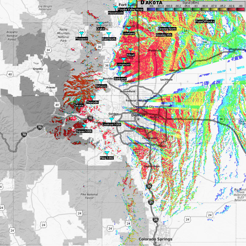
Dakota Mountain (1-024)
- Frequencies:
| Site | Name | Freqs | |||||||
|---|---|---|---|---|---|---|---|---|---|
| 024 (18) | Dakota Hill | 851.462500 | 851.962500c | 852.462500c | 852.962500c | 853.462500c | 854.487500 | 855.600000 | 858.025000 |
| 858.637500 |
- County Location: Gilpin
- Counties Covered: Gilpin, Jefferson, Clear Creek, western Boulder
- Agencies Frequently Affiliating: Jefferson County, Gilpin County, state agencies (CDOT, CSP) assigned to the area.
- Denied Affiliations: Most metro area talk groups, including state agencies not assigned to the area.
- Other Notes: The denials keep the amount of traffic to this site limited, although it can be received over a large area.
- Please click on the site name (in blue) in the database listing for more information
Approximate Coverage Map

[Click here for full resolution]
Back to Colorado DTRS site list
Refresh this page from the latest database entry