Difference between revisions of "Individual CO DTRS Sites/Riley"
From The RadioReference Wiki
m (updated Refreshpage link) |
|||
| Line 9: | Line 9: | ||
|OthNotes=None}} | |OthNotes=None}} | ||
| − | |||
| − | |||
===Approximate Coverage Map=== | ===Approximate Coverage Map=== | ||
| Line 20: | Line 18: | ||
[[Individual CO DTRS Sites|Back to Colorado DTRS site list]] | [[Individual CO DTRS Sites|Back to Colorado DTRS site list]] | ||
| + | |||
| + | |||
| + | |||
| + | |||
| + | |||
| + | |||
| + | |||
| + | {{Refreshpage}} | ||
[[Category: Colorado DTRS Site Information]] | [[Category: Colorado DTRS Site Information]] | ||
Latest revision as of 16:17, 10 November 2015
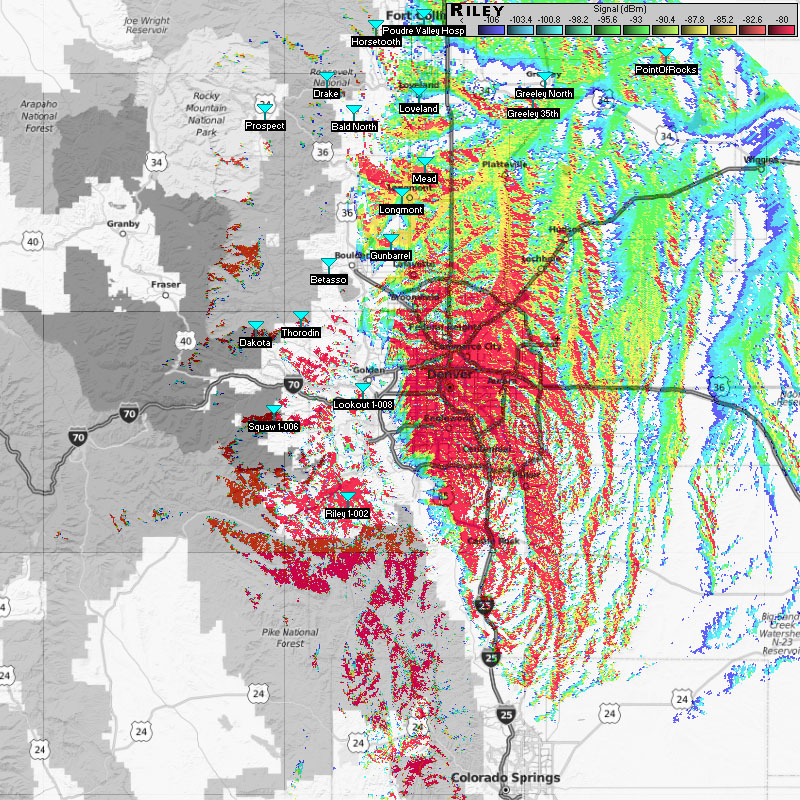
Riley Peak (1-002)
- Frequencies:
| Site | Name | Freqs | |||||||
|---|---|---|---|---|---|---|---|---|---|
| 002 (2) | Conifer Mountain | 851.350000 | 851.600000 | 851.925000 | 852.175000 | 852.587500 | 852.737500 | 853.337500 | 853.587500c |
| 853.912500c | 854.137500 | 854.762500 | 856.912500 | 857.162500 | 858.012500 |
- County Location: Jefferson
- Counties Covered: ?
- Agencies Frequently Affiliating: Denver Metro Area
- Denied Affiliations: Broomfield, Adams County, Weld county, Morgan county, Larimer County, Lincoln County, G/CC Mtn Tac
- Other Notes: None
- Please click on the site name (in blue) in the database listing for more information
Approximate Coverage Map

[Click here for full resolution]
Back to Colorado DTRS site list
Refresh this page from the latest database entry