Welcome to the Tulsa International Airport (TUL) aviation article, the airport located in Tulsa County, Oklahoma.
This is where you, the user, may index any articles, frequencies-lists, etc. that you develop for scanning related topics for this airport.
Tulsa International Airport (KTUL) Air Traffic Control
| VHF Frequency
|
UHF Frequency
|
Area of Control
|
Callsign
|
Note
|
| 121.20
|
310.80
|
Runways 36R/18L and 8/26
|
Tulsa Tower
|
Primary Local frequency that is used by all aircraft during times of low traffic
|
| 118.70
|
257.80
|
Runway 36L/18R
|
Tulsa Tower
|
Combined with 36R/18L and 8/26 frequency (121.2/310.0) during times of low traffic
|
| 121.90
|
348.60
|
Taxiways
|
Tulsa Ground
|
| 134.05
|
284.70
|
-
|
Tulsa Clearance Delivery
|
| 124.90
|
377.20
|
-
|
Automated Terminal Information System (ATIS)
|
Terminal Radar Approach Control (TRACON)
Tulsa Riverside Tower Pilot Information Handbook Excerpt
| VHF Frequency
|
UHF Frequency
|
Area of Control
|
Callsign
|
Note
|
| 124.00
|
338.30
|
Northwest sector
|
Tulsa Approach and Tulsa Departure
|
Primary frequency
|
| 119.10
|
351.80
|
North East sector
|
Tulsa Approach and Tulsa Departure
|
Combined with Northwest Sector during times of low traffic
|
| 134.70
|
n/a
|
Southwest sector
|
Tulsa Approach and Tulsa Departure
|
Combined with Northwest sector (124.00/338.30) during times of low traffic
|
| 119.85
|
381.20
|
Southwest Sector
|
Tulsa Approach and Tulsa Departure
|
Combined with Southwest Sector (134.70) 99% of time
|
| 132.10
|
319.90
|
Tulsa Inner Class C
|
Tulsa Approach and Tulsa Departure
|
Combined with Northwest sector (124.00/338.30) 99% of time
|
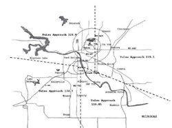
Information listed above is inconsistent between the KTUL and KRVS airport files. KTUL lists 119.85 as a final approach frequency and makes no mention of 134.70. KRVS lists 119.85 as the TRACON to the east of the airport. The information above is based off of the Tulsa Riverside Tower Pilot Information Handbook airspace map.
Airline Operations
American Airlines
|
Frequency |
Input |
License |
Type |
Tone |
Alpha Tag |
Description |
Mode |
Tag |
| 460.65000 |
465.65000 |
WNPC794 |
RM |
|
AmericanAirlines |
Ground Operations |
FMN |
Business |
| 460.80000 |
465.80000 |
KNBR346 |
RM |
|
AmericanAirlines |
Ground Operations |
FMN |
Business |
| 129.20000 |
|
WEI5 |
BM |
CSQ |
AmericanAirlines |
Air to Ground |
AM |
Aircraft |
| 129.32500 |
|
WEI5 |
BM |
CSQ |
AmericanAirlines |
Air to Ground Maintenance |
AM |
Aircraft |
Delta Airlines
|
Frequency |
Input |
License |
Type |
Tone |
Alpha Tag |
Description |
Mode |
Tag |
| 460.82500 |
465.82500 |
KKO374 |
RM |
115 DPL |
Delta Airlines |
Ground Operations |
FMN |
Business |
Frontier Airlines
Frontier Airlines has been granted the license WQGU734 with airline service scheduled to commence in spring 2018.
The following frequency pair is a prediction based off of the license listed above
| Frequency
|
Input
|
License
|
Type
|
Tone
|
Alpha Tag
|
Description
|
Mode
|
Tag
|
| 463.9625
|
468.9625
|
WQGU734
|
RM
|
|
FFT Ground Ops
|
Frontier Airlines Ground Operations
|
|
Business
|
Southwest Airlines
|
Frequency |
Input |
License |
Type |
Tone |
Alpha Tag |
Description |
Mode |
Tag |
| 451.48750 |
456.48750 |
WPEF932 |
RM |
115 DPL |
SW Airlines Grnd |
Ground Operations |
FMN |
Business |
| 131.70000 |
|
WPI3 |
BM |
CSQ |
SW Airlines Air |
Air to Ground |
AM |
Aircraft |
United Airlines
|
Frequency |
Input |
License |
Type |
Tone |
Alpha Tag |
Description |
Mode |
Tag |
| 464.77500 |
469.77500 |
WNQZ554 |
RM |
|
United Airlines |
Ground Operations |
DMR |
Business |
| 130.15000 |
|
KNT9 |
BM |
CSQ |
United Airlines |
Air to Ground |
AM |
Aircraft |
ACARS
There is an ACARS remote sounding on the airport. With the following licenses associated with it: KXI5, KGP2, WQJR360, and WCJ91
| Frequency
|
| 129.525
|
| 130.025
|
| 131.550
|
| 131.725
|
| 136.975
|
Wiki Articles
External Links

