Hamilton County (TN)
From The RadioReference Wiki
Return to Hamilton County TN Database page
Return to Tennessee main Database page and/or [ WIKI]
Contents
Hamilton County
Tennessee Advanced Communications Network (TACN) Project 25 Phase II Used by all county agencies/Public Safety. It appears that all talkgroups are TDMA (Phase II)
154.16 EOC Channel is used for dispatching these agencies:
- Dallas Bay VFD, Flat Top VFD, Highway 58 VFD, Mowbray VFD, Sequoyah VFD, S.T.A.R.S., Hamilton County Marine Rescue
Hamilton County Sheriff
Hamilton County Jail and Detention Center
- New DMR system on WRMM385 453.1625, 453.3375, 453.6625
Formerly known as Silverdale Detention Center, formerly under contract of CoreCivic/CCA WikiPedia
- 451.9375 Repeater D047 WPHG717 Expired 9/25; frequency taken over by Dalton Communications Trunked system at CH Memorial Hospital WQXK944
55-2W Portables on 451.1875, 451.2375, 451.2875, 451.3125 Deprecated 5/14/26
Municipalities
Chattanooga
Collegedale
East Ridge
- Public Works - 39.82 Base/Mobiles 136.5 PL KCJ957 [Expired 10/22] FM Still listed, no new licence 5/14/26
Lookout Mountain
- Police - Car-to-Car - 460.375 Repeater 107.2 PL KNAG590 [Expired 2/12] Still listed, no new license 5/14/26
Red Bank
- Fire: Paging (Operations on TRS) - 154.325 BM 186.2 PL KJU331 [Expired 7/15] Still listed, no new license 5/14/26
Signal Mountain
- Police: Car-to-Car - 854.9875R/809.9875 127.3 PL WPCA875 [Expired 1/24] No new license, still listed 5/14/26
- Walden's Ridge Emergency Service - 154.445 BM 136.5 PL KIJ542 [Expired 11/12] FMN Deprecated 5/14/26
Soddy Daisy
Hospitals / EMS
Chattanooga/Hamilton County Hospital Authority
Memorial Hospital (Walden)
- Memorial Hospital EMS - 152.87R/160.08 225.7 PL WPYX405 [Expired 11/13] Deprecated 5/14/26, no new license
Chattanooga Area Regional Transport (CARTA) WEB
Hamilton County Schools
- 154.055 repeater is used by buses operated by independent contractors.
Unit Designators / Tone-Outs
Chattanooga Fire Department
- Q: Quint
- E: Engine
- L: Ladder
- S: Squad
- HM: Haz-Mat Unit
- USAR: Urban Search and Rescue Unit
- W: Water Tender (Tanker)
- MP: Mini Pumper
- HT: Hose Truck
- BT: Brush Truck
- FB: Fire Boat
- BC: Battalion Chief
District 1 covers the following fire stations: 1, 3, 5, 9, 14, 20. District 2 covers the following fire stations: 6, 7, 8, 13, 15, 21. District 3 covers the following fire stations: 4, 10, 11, 12, 16, 17, 19, 22.
| Station | Address | Equipment | Notes |
|---|---|---|---|
| 1 | 218 East Main Street | Q1, S1, L1, HM1, BC1 | |
| 3 | 5 Francis St | Q3, W3 | |
| 4 | 2181 Curtis Street | E4 | |
| 5 | 809 South Willow Street | E5, L5 | |
| 6 | 4500 Bonny Oaks Drive | Q6, FB6 | |
| 7 | 6911 Discovery Drive | L7, S7, USAR-2, HM2, BC2 | |
| 8 | 2130 Hickory Valley Road | Q8, W8 | |
| 9 | 3250 8th Avenue | E9 | |
| 10 | 910 Wisdom Street | Q10, BT10, FB10 | |
| 11 | 6406 Hixson Pike | E11 | |
| 12 | 906 Forrest Avenue | E12 | |
| 13 | 5201 Brainerd Road | L13, S13 | |
| 14 | 1009 West 39th Street | Q14 | |
| 15 | 912 Shallowford Road | E15 | |
| 16 | 3423 Lupton Drive | Q16, BC3 | |
| 17 | 628 Signal Mountain Road | Q17, W17, HT1 | |
| 19 | 5400 Brunswick Lane | L19, S19, USAR-1 | |
| 20 | 3003 Cummings Highway | S20, BT20 | |
| 21 | 7700 East Brainerd Road | Q21, W21 | |
| 22 | 6144 Dayton Boulevard | E22, W22, BT22 |
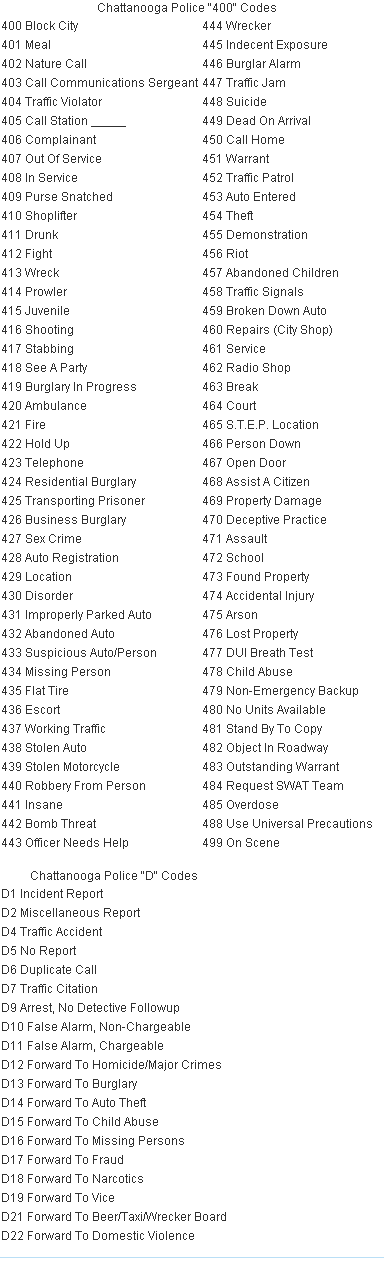
Chattanooga Police 400 and D Codes
Chattanooga Police Patrol Zones
Sector One (Adam): Adam North | Adam Central | Adam South
Adam North (formerly Alpha Zone) consists of North Chattanooga, Riverview, Mountain Creek, Signal Mountain Road area, Hixson and Middle Valley.
Adam Central (formerly Bravo Zone) consists of Coolidge Park, Renaissance Park, the North Shore (and the entire Waterfront), the downtown area, MLK Boulevard and Main Street areas, Lincoln Park, and the Westside Community.
Adam South (formerly Charlie Zone) consists of South Chattanooga, St. Elmo, Alton Park, Tiftonia and Lookout Valley.
Sector Two (Baker): Baker North | Baker South
Baker North (formerly Echo Zone) consists of Youngstown Road from Bonny Oaks Drive to Lightfoot Mill Road on the North, North Crest Road on the East, McCallie Avenue on the South and the river on the West.
Baker South (formerly Fox Zone) consists of Ridgedale, Highland Park and Eastlake. I-24 East and West is included in Baker South. This zone also borders with Baker North, Adam Central and Charlie.
Sector Three (Charlie): Charlie South | Charlie North
Charlie South (formerly Delta Zone) consists of the Chattanooga Metropolitan Airport, Eastgate Town Center, and the I-75 and I-24 split.
Charlie North (formerly George Zone) consists of Highway 58, East Brainerd, and the Ooltewah area. I-75 and Hwy 153 are also included in Charlie North.
http://www.chattanooga.gov/police-department/neighborhood-policing
Hamilton County EMS
Hamilton County Sheriff Radio Codes
- Code 6 - Busy
- Code 7 - Warrant
- Code 9 - Cancel
- Code 10 - Switch to Talk
- Code 12 - Reports
- Code 42 - Station "R" (Residence)
- Code 101 - Juvenile
HCES Unit Numbers
| Unit | Address | Community |
|---|---|---|
| Medic 1 | 9022 Career Lane | Ooltewah |
| Medic 2 | US Highway 27 South of Coleman Rd | Sale Creek |
| Medic 3 | Discovery Dr | Enterprise South Industrial Complex |
| Medic 4 | Tn Highway 153 at Winding Lane | Hixson |
| Medic 5 | 10962 Apison Pk | Apison |
| Medic 6 | Ashmore Avenue North of Dayton Blvd. | Red Bank |
| Medic 7 | Crane Rd west of Gunbarrel Rd. | East Brainerd |
| Medic 8 | Rolling Way west of Taft Hwy | Signal Mountain |
| Medic 9 | Long Street at 19th street | Downtown Chattanooga |
| Medic 10 | Cummings Hwy at Browns Ferry Rd | Tiftonia |
| Medic 11 | North Moore Rd. south of Vannoy Dr. | Brainerd |
| Medic 12 | Middle Valley Road at Dallas Hollow Rd. | Soddy Daisy |
| Medic 13 | Long Street at 19th Street | Downtown Chattanooga |
| Medic 14 | Riverside Lane at Amnicola Hwy. | Chattanooga |
| Medic 15 | Discovery Dr | Enterprise South Industrial Complex |
| Medic 16 | 1410 Saint Thomas St | East Ridge |
| Unit Number | Agency |
|---|---|
| 700 | Chattanooga Hamilton County Rescue Service |
| 1100 | Hamilton County Hazardous Materials Team |
| 1200 | Tri Community VFD |
| 1300 | Dallas Bay VFD |
| 1400 | Mowbray VFD |
| 1600 | Highway 58 VFD |
| 1700 | Sequoyah VFD |
| 1800 | Sale Creek VFD |
| 1900 | Volunteer State Rescue Squad |
| 2100 | Special Tactics and Rescue Service (STARS) |
| 2200 | Flattop VFD |
| 2300 | Walden Ridge Emergency Service |
| 2600 | Command Post Personnel |
| 2700 | Emergency Operations Center Personnel |
- Unit numbers are 4 or 5 digits (except 700 series). As an example, possible Dallas Bay units could be 1341 or 13210
Tri Community Volunteer Fire
Station 1 - 9755 Sanborn Drive
- 1241 - Engine - 1983/1991 Pierce (500 Gallon Tank, 1000 GPM Pump)
- 1251 - Pumper/Tanker - 1988 E-One (1500 Gallon Tank, 2000 GPM Pump)
- 1271 - Ladder - 2009 Rosenbauer 109' Quint
- 1281 - Heavy Rescue - 2002 HME/Central States
- 1280 - Rescue/Air - 1987 Spartan/Saulsbury
- 1288 - Confined Space/Rescue - 1974 Imperial
- 1291 - Brush - 1991 GMC Pickup (300 Gallon Tank, 200 GPM Pump)
- 1297 - Medical ALS/Support - 1997 Chevrolet
Station 2 - 7230 Mountain View Road
- 1242 - Engine - 1991 Spartan 4Guys
- 1252 - Pumper/Tanker - 1993 International/E-One
Station 3 - 4507 Bill Jones Road
- 1243 - Engine - 2013 Rosenbauer
- 1273 - Ladder - 1987 Pierce Arrow 95ft Aerial Platform
- 1293 - Medical BLS/Service - 1993 GMC Pickup
Station 4 - 9515 Lee Highway
- 1244 - Rescue Pumper - 2001 HME/Central States (750 Gallon Tank, 1500 GPM Pump)
- 1254 - Pumper/Tanker - 1994 Pierce (1250 Gallon Tank, 1250 GPM Pump)
- 1270 - Ladder - 1987 Pierce Arrow 105' Quint
- 1294 - Brush - 1993 GMC Pickup (250 Gallon Tank, 200 GPM Pump)
- 1298 - Utilimaster Pickup - 1988 Chevrolet
Station 5 - 8327 Standifer Gap Road
- 1245 - Rescue Pumper - 2001 HME/Central States (750 Gallon Tank, 1500 GPM Pump)
- 1250 - Pumper/Tanker (Reserve) - 1976/2006 International/Central States (1000 Gallon Tank, 750 GPM Pump)
- 1265 - Tanker - 1979 Mack MR (3000 Gallon Tank, 300 GPM Pump)
- 1296 - Medical BLS/Service - 2004 Ford F450 Super Duty Utility
Administration/Training - 9769 Sanborn Drive
Hamilton County Fire/EMS Stations
Chattanooga Fire
- Sta. #1 - 218 E. Main St. (aka US-41) @ Rossville Ave., Chattanooga
- Sta. #3 -
- Current Sta. - 5 Francis St. between Cummings Hwy. (aka US-41) & Kellys Ferry Rd., Chattanooga
- Former Sta. - 513 Georgia Ave. between E. 5th St. & Vine St., Chattanooga
- Sta. #4 - 2181 Curtis St. @ Dodson Ave. (aka State Route 17), Chattanooga
- Sta. #5 -
- Current Sta. - 2009 Vance Ave. between S. Willow St. (aka State Route 17) & S. Beech St., Chattanooga
- Former Sta. - 809 S. Willow St. (aka State Route 17) @ Vance Ave., Chattanooga
- Sta. #6 - 4510 Bonny Oaks Dr. (aka State Route 317) across from Wilson St., Chattanooga
- Sta. #7 - 6911 Discovery Dr. @ Claude Ramsey Pkwy., Chattanooga (Bays face Claude Ramsey Pkwy.)
- Sta. #8 - 2103 Hickory Valley Rd. between Lee Hwy. (aka State Route 2/US-11/US-64) & Vaden Dr., Chattanooga
- Sta. #9 -
- Current Sta. - 3250 8th Ave. between E. 32nd St. & E. 34th St., Chattanooga
- Former Sta. - 3701 6th Ave. @ E. 37th St., Chattanooga
- Sta. #10 (HQ) - 910 Wisdom St. between Belle Arbor Ave. & Elmendorf Cir., Chattanooga
- Sta. #11 - 1530 Destiny Dr. between Hixson Pike (aka State Route 319) & Serenade Ln., Hixson
- Sta. #12 -
- Current Sta. - 902 Forest Ave. @ Wells St., Chattanooga
- Former Sta. - 906 Forest Ave. @ Sylvan St., Chattanooga
- Sta. #13 - 5201 Brainerd Rd. (aka State Route 2/US-11/US-64) @ N. Howell Ave., Chattanooga
- Sta. #14 - 1009 W. 39th St. @ Pirola St. & across from W. 40th St. (aka State Route 58), Chattanooga
- Sta. #15 - 912 Shallowford Rd. between Gillespie Rd. & Curleque Dr., Chattanooga
- Sta. #16 - 1033 Lupton Dr. between Hixson Pike & Dixie Dr., Lupton City
- Sta. #17 - 628 Signal Mountain Rd. (aka US-127) @ Mundy St., Chattanooga
- Sta. #18 - 1000 Jubilee Dr. between Brainerd Rd. (aka US-64) & Dead End, Chattanooga (Sta. is aka Chattanooga Metropolitan Airport F.D. and sits at the following coordinates: 35.03469/-85.20572)
- Sta. #19 - 5000 Brunswick Ln. between Hixson Pike (aka State Route 319) & Dead End, Hixson
- Sta. #20 - 3003 Cummings Hwy. (aka US-41) @ Browns Ferry Rd., Chattanooga (Bays face Kellys Ferry Rd.)
- Sta. #21 - 7700 E. Brainerd Rd. (aka State Route 320) between Reserve Way & Jenkins Rd., Chattanooga
- Sta. #22 - 6144 Dayton Blvd. @ Colony Cir., Hixson
- Chattanooga-Hamilton Co. Rescue Service (Dept. #7) - 5910 Lee Hwy. (aka State Route 2/US-11/US-64) @ Whirlaway Dr., Chattanooga (Bay faces Whirlaway Dr.) (KNCY658)
- Chattanooga Metropoliltan Airport F.D. - 1000 Jubilee Dr. between Brainerd Rd. (aka US-64) & Dead End, Chattanooga (Sta. is also known as Chattanooga F.D. - Sta. #18 and sits at the following coordinates: 35.03469/-85.20572)
- Dallas Bay Fire & Rescue (Dept. #13) -
- Sta. #1 - 7525 Middle Valley Rd. between Gann Rd. & Forest Edge Dr.,Hixson
- Sta. #2 (HQ) - 1950 McConnell School Ln. between Hixson Pike (aka State Route 319) & Camp Columbus Rd., Hixson
- Sta. #3 - 6918 Levi Rd. between Ray Ln. & Roberts Mill Rd., Hixson
- East Ridge Fire/Rescue -
- Sta. #1 (HQ) - 4214 Ringgold Rd. (aka US-41) between Marlboro Ave. & Tombras Ave., East Ridge (KZG287)
- Sta. #2 - 1410 St. Thomas St. between Wright St. & Dead End, Chattanooga
- Flat Top V.F.D. (Dept. #22) - 13341 Jones Gap Rd. between Smith Rd. & Reed Ln., Soddy-Daisy
- Hamilton Co. E.M.S. -
- HQ - 317 Oak St. between Georgia Ave. & Lindsay St., Chattanooga
- Sta. #1 -
- Current Sta. - 10918 State Route 58 between Thomas Ln. & Runyan Rd., Georgetown
- Former Sta. - 9022 Career Ln. between Mahan Gap Rd. (aka State Route 312/County Route 1124) & State Route 58 (aka State Route 312), Harrison (Now Hamilton Co. Special Tactics & Rescue Services (S.T.A.R.S.))
- Sta. #2 - 12906 Dayton Pike (aka US-27) between Coleman Rd. & Vision Rd., Soddy-Daisy
- Sta. #3 - 7123 Discovery Dr. between Volkswagen Dr. & Tennessee, Alabama & Georgia (TAG) Railway Tracks, Chattanooga
- Sta. #4 - 1001 Towne Hills Dr. @ Winding Ln., Hixson (Sta. #4 faces Winding Ln.)
- Sta. #5 - 10962 Apison Pike (aka State Route 317) between Short Cut Rd. & Sandy Trl., Apison
- Sta. #6 - 1105 Ashmore Ave. between Mason Dr. & Coker Cir., Red Bank
- Sta. #7 - 7233 Crane Rd. across from Farris Rd., Chattanooga (Sta. #7 sits at the following coordinates: 35.02403/-85.16183)
- Sta. #8 - 311 Rolling Way between Ridgeway Ave. (aka US-127) & James Blvd., Signal Mountain
- Sta. #9 - 1812 Long St. @ W. 19th St., Chattanooga
- Sta. #10 - 18 N. Tulip Ave. between Cummings Hwy. (aka US-41) & Kellys Ferry Rd., Chattanooga
- Sta. #11 - 1158 N. Moore Rd. between Vannoy Dr. & Belle Vista Dr., Chattanooga
- Sta. #12 - 8513 Middle Valley Rd. between Daisy-Dallas Rd. & W. Crabtree Rd., Soddy-Daisy
- Sta. #14 - 2900 Riverport Rd. between Amnicola Hwy. (aka State Route 58) & River Centre Rd., Chattanooga
- Sta. #15 - 8881 Snowy Owl Rd. between Snow Line Ln. & Snow Cone Way, Ooltewah
- Sta. #16 - 1505 Waterhouse St. between Ringgold Rd. (aka State Route 8/US-41/US-76) & McKinley St., East Ridge
- Hamilton Co. Special Ops/HazMat (Dept. #11) - 3420 Amnicola Hwy. (aka State Route 58) @ Wisdom St., Chattanooga (Sta. sits along Belle Arbor Ave. @ the following coordinates: 35.081722/-85.261816)
- Hamilton Co. Special Tactics & Rescue Services (S.T.A.R.S.) (Dept. #21) - 9022 Career Ln. between Mahan Gap Rd. (aka State Route 312/County Route 1124) & State Route 58 (aka State Route 312), Harrison (Formerly Hamilton Co. E.M.S. - Sta. #1)
- Highway 58 V.F.D. (Dept. #16) -
- Sta. #1 (HQ) - 5402 State Route 58 between Claude Ramsey Pkwy. & Jewell Rd., Chattanooga
- Sta. #2 - 9018 Career Ln. between State Route 58 (aka State Route 312) & Mahan Gap Rd. (aka State Route 312/County Route 1124), Harrison
- Sta. #3 - 13430 Birchwood Pike (aka State Route 312/County Route 605) between Eldridge Rd. & Grasshopper Rd., Birchwood
- Sta. #4 - 10916 State Route 58 between Thomas Ln. & Runyan Rd., Georgetown
- Sta. #5 - 6209 Cooley Rd. between Birchwood Pike (aka State Route 312/County Route 605) & Poppi Ln., Harrison
- Training Center - 9108 Snow Hill Rd. between Mahan Gap Rd. (aka State Route 312/County Route 1124) & Davis Wolfe Ln., Ooltewah
- Lifeguard Amb. Service - 2050 S. Kelly St. between E. 20th St. & E. 23rd St. (aka State Route 2/US-11/US-64), Chattanooga ***(NOW CLOSED)*** (Bldg. sits back from the road @ at the following coordinates: 35.01834/-85.27813)
- Lone Oak V.F.D. - 1278 US-127 (aka State Route 8/Taft Hwy.) @ School House Rd., Signal Mountain (Sequatchie Co.)
- Lookout Mountain D.P.S. - 710 Scenic Hwy. (aka W. Brow Rd.) across from W. Sunset Rd., Lookout Mtn. (Sta. sits back from the road @ at the following coordinates: 34.99536/-85.35363).
- Mowbray V.F.D. (Dept. #14) - 1705 Mowbray Pike (aka County Route 1126) between Arnat Dr. & Carey Rd., Soddy-Daisy
- Prestige Patient Transport - 5512 Ringgold Rd. (aka State Route 8/US-41/US-76) @ Maxwell Rd., East Ridge
- Puckett E.M.S. -
- HQ - 3014 Rossville Blvd. (aka US-27) @ E. 31st St., Chattanooga
- Sub Sta. - 9402 Reco Dr. between Harrison Ln. & Dead End, Soddy-Daisy (Sub Sta. is at the Parkridge Soddy-Daisy E.R. & sits at the Dead End)
- Red Bank F.D. -
- Sta. #1 (HQ) - 3127 Dayton Blvd. @ W. Newberry St., Red Bank (Bays face W. Newberry St.)
- Sta. #2 - 4851 Dayton Blvd. between Freudenburg Ln. & Appian Way, Chattanooga
- Sale Creek V.F.D. (Dept. #18) (WYC619) -
- Sta. #1 (HQ) - 14828 Dayton Pike (aka US-27) across from Reavley Rd., Sale Creek
- Sta. #2 - 15021 Back Valley Rd. between Leggett Rd. & Union St., Sale Creek
- Sta. #3 - 13535 Mt. Tabor Rd. between Lee Pike & Lillard Rd., Soddy-Daisy
- Sta. #4 - 15936 May Rd. between Poole Rd. & Daugherty Ferry Rd., Sale Creek
- Sta. #5 - 14705 Dayton Pike (aka US-27) between Reavley Rd. & Sale Creek Ln., Sale Creek (Sta. #5 sits behind Sale Creek Outdoor Power Equipment & Service and was formerly Sta. #1)
- Sequoyah V.F.D. (Dept. #17) -
- Sta. #1 (HQ) - 1989 Green Pond Rd. between Hixson Pike (aka State Route 319/County Route 603) & Dodd Cemetery Rd., Soddy-Daisy
- Sta. #2 - 9514 W. Ridge Trail Rd. between Lovell Rd. & Lena Ln., Soddy-Daisy
- Sequoyah Nuclear Plant Fire Brigade - 2620 Igou Ferry Rd. across from Sequoyah Access Rd. (aka County Route 2158), Soddy-Daisy (Unknown where on the property the Fire Sta. is)
- Signal Mountain F.D. -
- Sta. #1 (HQ) - 1100 Ridgeway Ave. (aka US-127/Taft Hwy.) @ Rolling Way, Signal Mtn. (Bays face Rolling Way)
- Sta. #2 - 5240 Shackleford Ridge Rd. between Mountain Hollow Dr. & Windtree Dr., Signal Mtn.
- Soddy-Daisy F.D. (WRQZ661) -
- Sta. #1 (HQ) - 10116 Card Rd. @ Dayton Pike, Soddy-Daisy
- Sta. #2 - 11651 Dayton Pike @ Depot St., Soddy-Daisy
- Sta. #3 - 9009 Dayton Pike between Nale Rd. & W. Walden Cir., Soddy-Daisy
- Tri-Community V.F.D. (Dept. #12) -
- Sta. #1 (Collegedale) - 9755 Sanborn Dr. between Apison Pike (aka State Route 317) & Dead End, Collegedale
- Sta. #2 (Mountain View) - 7230 Mountain View Rd. @ Ooltewah-Georgetown Rd. (aka County Route 1145), Ooltewah (WQBH303)
- Sta. #3 (Apison) -
- Current Sta. - 11115 Park Pl. between Bill Jones Rd. & Old E. Brainerd Rd., Apison (WQBH303)
- Former Sta. - 4507 Bill Jones Rd. between Park Pl. & First St., Apison (Former Sta. #3 is now Fleet Services)
- Sta. #4 (Ooltewah) - 9515 Lee Hwy. (aka State Route 2/US-11/US-64) between Chesterton Way & Edgmon Rd., Ooltewah
- Sta. #5 (Standifer Gap) - 8327 Standifer Gap Rd. (aka County Route 2154) between Maplewood Dr. & Hope Valley Trl., Chattanooga (WQBH303)
- Sta. #6 (East Brainerd) - 9535 E. Brainerd Rd. (aka State Route 320) between Fuller Rd. & James Allen Trl., Chattanooga ***(Future Sta.)***
- Sta. #7 (HQ - Support Services) - 9769 Sanborn Dr. between Apison Pike (aka State Route 317) & Dead End, Collegedale (WQBH303)
- Waldens Ridge Emergency Services (Dept. #23) -
- Sta. #1 (HQ) - 2100 Taft Hwy. (aka State Route 8/US-127) between Timesville Rd. & Chicory Pl., Signal Mountain
- Sta. #2 - 7339 Sawyer Pike across from Tuckahoe Pass, Signal Mountain
Related Pages
- Utilities (No WIKI, see businesses)
- Schools, Colleges (No WIKI, see main county page)
- Hospitals (No WIKI, see businesses)
- Manufacturing (No WIKI, see businesses)
Airports
- Chattanooga Metropolitan Airport (CHA) (No WIKI, see main county page)
- Collegedale Municipal Airport (No WIKI, see main county page)
- Dallas Bay Sky Park (No WIKI, see main county page)