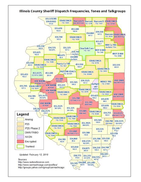
IL County Sheriff Dispatch frequencies map.jpg
From The RadioReference Wiki
Revision as of 23:29, 8 March 2017 by Cubn (talk | contribs) (uploaded a new version of "File:IL County Sheriff Dispatch frequencies map.jpg": Changed McDonough to 453.4375 DMR)
Revision as of 23:29, 8 March 2017 by Cubn (talk | contribs) (uploaded a new version of "File:IL County Sheriff Dispatch frequencies map.jpg": Changed McDonough to 453.4375 DMR)

Size of this preview: 463 × 599 pixels. Other resolutions: 185 × 240 pixels | 816 × 1,056 pixels.
Original file (816 × 1,056 pixels, file size: 515 KB, MIME type: image/jpeg)
Illinois County Sheriff Dispatch Frequencies map (will be updated if frequencies or systems change)
File history
Click on a date/time to view the file as it appeared at that time.
(newest | oldest) View (newer 10 | older 10) (10 | 20 | 50 | 100 | 250 | 500)
| Date/Time | Thumbnail | Dimensions | User | Comment | |
|---|---|---|---|---|---|
| current | 18:27, 12 February 2018 | | 816 × 1,056 (515 KB) | Cubn (talk | contribs) | changed Greene Co to NXDN enc |
| 22:46, 8 February 2018 |  | 816 × 1,056 (514 KB) | Cubn (talk | contribs) | Changed Vermilion Co to DMR encrypted | |
| 23:42, 21 December 2017 |  | 816 × 1,056 (513 KB) | Cubn (talk | contribs) | Changed Will Co to say "multiple TGs" | |
| 21:33, 15 December 2017 |  | 816 × 1,056 (515 KB) | Cubn (talk | contribs) | updated Douglas and Will Counties |
- You cannot overwrite this file.
File usage
The following page uses this file: