Difference between revisions of "Aitkin County (MN)"
From The RadioReference Wiki
| Line 10: | Line 10: | ||
|Mn/DOT District = 3 | |Mn/DOT District = 3 | ||
|DNR District = 7, 9 and 10 | |DNR District = 7, 9 and 10 | ||
| − | |ARMER | + | |ARMER Region = 6 |
| + | |FBI HQ = Minneapolis | ||
| + | |FBI RA = Duluth | ||
|EMS Region = Northeast | |EMS Region = Northeast | ||
|ctid = 1310}} | |ctid = 1310}} | ||
| Line 51: | Line 53: | ||
==ARMER Migration== | ==ARMER Migration== | ||
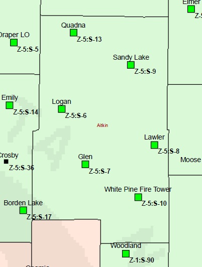
[[Image:AitkinMNARMER.jpg]] | [[Image:AitkinMNARMER.jpg]] | ||
| − | *Status - Planning to | + | *Status - Planning to migrate to ARMER |
*Sites and Status: | *Sites and Status: | ||
| − | + | {|class="wikitable sortable collapsible" border=1 style=border-collapse:collapse cellpadding=3 | |
| − | + | !Site!!Site Name!!Status!!LatDMS!!LonDMS!!FCC Lic.!!CC 1!!CC 2 | |
| − | + | |- | |
| − | + | |5-006||Logan||[[Image:ARMERCO.jpg]]||46.41407N||93.36160W||WQKS343|| || | |
| − | + | |- | |
| − | ** | + | |5-007||Glen||[[Image:ARMERCO.jpg]]||46.28143N||93.30033W||WQKS343|| || |
| + | |- | ||
| + | |5-008||Lawler||[[Image:ARMEROA.jpg]]||46.32019N||93.07531W||WQKS343||853.9125|| | ||
| + | |- | ||
| + | |5-009||Sandy Lake||[[Image:ARMERRF.jpg]]||46.50090N||93.15309W||WQKS343|| || | ||
| + | |- | ||
| + | |5-010||White Pine Fire Tower||[[Image:ARMERCO.jpg]]||46.20011N||93.13225W||WQKS343|| || | ||
| + | |- | ||
| + | |5-013||Quanda||[[Image:ARMEROA.jpg]]||46.57458N||93.35138W||WQKS343||856.2375|| | ||
| + | |} | ||
| + | |||
| + | ==Trunked Radio Systems== | ||
| + | *[[Allied Radio Matrix for Emergency Response (ARMER)]] (800 [[Project 25]] Phase I) | ||
| + | *[[Great River Energy]] (UHF [[Motorola Type II SmartZone OmniLink]] | ||
| + | |||
| + | ==Airports== | ||
| + | *[[Aitkin Municipal Airport (AIT) Aitkin County (MN)|Aitkin Municipal Airport (Steve Kurtz Field)]] | ||
| + | *[[Hill City - Quadna Mountain Airport (07Y) Aitkin County (MN)|Hill City - Quadna Mountain Airport]] | ||
| + | *[[Isedor Iverson Airport (HZX) Aitkin County (MN)|Isedor Iverson Airport]] | ||
| + | |||
| + | ==Recommended Scanning== | ||
| + | ===VHF=== | ||
| + | |||
| + | ===ARMER=== | ||
{{Geographic Location | {{Geographic Location | ||
| Line 71: | Line 96: | ||
|Northwest = [[Cass County (MN)|Cass County]] | |Northwest = [[Cass County (MN)|Cass County]] | ||
}} | }} | ||
| + | |||
| + | Return to [[Minnesota (US)|Minnesota]] | ||
[[Category:Midwest Region]] | [[Category:Midwest Region]] | ||
Revision as of 15:17, 20 June 2011
Welcome to the Aitkin County, Minnesota collaboration article. This is where you, the user, may index any articles you develop for scanning related topics for your area.
Contents
Law Enforcement Agencies
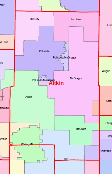
- Aitkin County Sheriffs Office
- Aitkin Police Department
- Hill City Police Department
- McGregor Police Department
Fire Departments
- Hill City Fire
- Jacobson Fire
- Palisade Fire
- McGregor Fire
- Aitkin Fire
- McGrath Fire
- Garrison Fire
- Isle Fire
- Kettle River Fire
- Willow River Fire
- Finlayson Fire
Emergency Medical Services
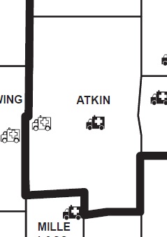
- McGregor Ambulance (BLS)
- North Memorial Ambulance - Aitkin (ALS)
- Meds 1 Ambulance (ALS)
First Response Agencies
- Aitkin First Responders
- Hill City First Responders
ARMER Migration
- Status - Planning to migrate to ARMER
- Sites and Status:
Trunked Radio Systems
- Allied Radio Matrix for Emergency Response (ARMER) (800 Project 25 Phase I)
- Great River Energy (UHF Motorola Type II SmartZone OmniLink
Airports
- Aitkin Municipal Airport (Steve Kurtz Field)
- Hill City - Quadna Mountain Airport
- Isedor Iverson Airport
Recommended Scanning
VHF
ARMER

|
Cass County | Itasca County | St. Louis County | 
|
| Carlton County | ||||
| Crow Wing County | Kanabec County and Mille Lacs County | Pine County |
Return to Minnesota


