Difference between revisions of "Medevac (WI)"
From The RadioReference Wiki
| Line 1: | Line 1: | ||
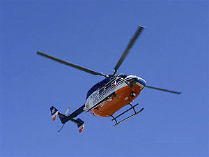
| + | [[image:Flightforlife.jpg|300px|right]] | ||
| + | Medical flight request are general mad by a local agency through their own dispatch. The local dispatch will contact the flight provider for the area, and inquire of their availability. Medical Crews are dispatched by their own dispatch and then contact the Incedent Comand on MARC2(151.280)''primary'' or EMS C(155.280)''secondary''. Some Areas that are not using conventional VHF channels may have a dedicated Talkgroup for Medical Flights and may use that for coordination instead. | ||
| + | |||
| + | =Wisconsin Medical Flight Providers= | ||
| + | *[http://www.flightforlife.org Flight for Life] - Eastern Wisconsin | ||
| + | *[http://www.uwhealth.org/med-flight/med-flight/20432 UW MED Flight] - South-central Wisconsin | ||
| + | *[http://www.thedacare.org/For-Medical-Professionals/ThedaStar.aspx Theda Star] - Central Wisconsin | ||
| + | *[http://www.eagle3.org/index.php Eagle III] - North-East Wisconsin | ||
| + | *[http://ministryhealth.org/MinistryHealth/Services/SpiritMedicalTransportationServices.nws Spirit Air] - North Central Wisconsin | ||
| + | *[http://www.aspirus.org/ourServices/index.cfm?catID=1&subCatID=57&pageID=707 Aspirus Medevac] - Northern Wisconsin & UP Michigan | ||
| + | *[http://www.lifelinkiii.com/ Life Link III] - Western Wisconsin & Minnesota | ||
| + | *[http://www.mayoclinic.org/medical-transport/ Mayo One] - Western Wisconsin & Minnesota | ||
| + | *[http://www.gundluth.org/MLA MedLink AIR] - South-Western Wisconsin, Minnesota, & Iowa | ||
| + | |||
| + | ==Coverage Maps== | ||
| + | *[http://www.lifelinkiii.com/pdf/response-map.pdf Life Link Coverage Map] | ||
| + | *[http://www.mayoclinic.org/medical-transport/mayoone.html Mayo One Coverage Map] | ||
| + | *[http://www.gundluth.org/upload/images/MedLink/MedLink2.jpg Med Link Coverage Map] | ||
| + | *[http://flightforlife.org/FlightforLife/AboutUs/FlightForLifeTransportSystemMap1 Flight for Life Coverage Map] | ||
| + | *[http://www.uwhealth.org/med-flight/med-flight-service-area/20438 UW Med Flight Coverage Map] | ||
| + | *[http://ministryhealth.org/MinistryHealth/Services/SpiritMedicalTransportationServices/FlightServiceArea.nws Spirit Air Coverage Map] | ||
| + | |||
| + | |||
==Flight For Life Landing Zone Coordination== | ==Flight For Life Landing Zone Coordination== | ||
*Milwaukee County Med Unit LZ Coordination = Talkgroup 32400 on MCTRS | *Milwaukee County Med Unit LZ Coordination = Talkgroup 32400 on MCTRS | ||
| Line 7: | Line 30: | ||
*Ozaukee County Fire LZ Coordination = 155.595 (173.8 PL) | *Ozaukee County Fire LZ Coordination = 155.595 (173.8 PL) | ||
| + | =Links= | ||
| + | *[http://www.wisconsinamc.org/ Wisconsin Air Medical Council] | ||
| + | |||
| + | |||
| + | ---- | ||
[[Category:Midwest Region]][[Category:Medical]] | [[Category:Midwest Region]][[Category:Medical]] | ||
only | only | ||
Revision as of 12:48, 4 December 2012
Medical flight request are general mad by a local agency through their own dispatch. The local dispatch will contact the flight provider for the area, and inquire of their availability. Medical Crews are dispatched by their own dispatch and then contact the Incedent Comand on MARC2(151.280)primary or EMS C(155.280)secondary. Some Areas that are not using conventional VHF channels may have a dedicated Talkgroup for Medical Flights and may use that for coordination instead.
Contents
Wisconsin Medical Flight Providers
- Flight for Life - Eastern Wisconsin
- UW MED Flight - South-central Wisconsin
- Theda Star - Central Wisconsin
- Eagle III - North-East Wisconsin
- Spirit Air - North Central Wisconsin
- Aspirus Medevac - Northern Wisconsin & UP Michigan
- Life Link III - Western Wisconsin & Minnesota
- Mayo One - Western Wisconsin & Minnesota
- MedLink AIR - South-Western Wisconsin, Minnesota, & Iowa
Coverage Maps
- Life Link Coverage Map
- Mayo One Coverage Map
- Med Link Coverage Map
- Flight for Life Coverage Map
- UW Med Flight Coverage Map
- Spirit Air Coverage Map
Flight For Life Landing Zone Coordination
- Milwaukee County Med Unit LZ Coordination = Talkgroup 32400 on MCTRS
- Waukesha County (TRS depts) Fire LZ Coordination = Talkgroup 13168 on WCTRS
- Sheboygan County Fire LZ Coordination = Talkgroup 13488 on SCTRS
- Racine County Fire LZ Coordination = 458.8 (100.0 PL)
- Washington County Fire LZ Coordination = 155.595 (173.8 PL)
- Ozaukee County Fire LZ Coordination = 155.595 (173.8 PL)
Links
only
