US Forest Service - Pike National Forest (CO)
From The RadioReference Wiki
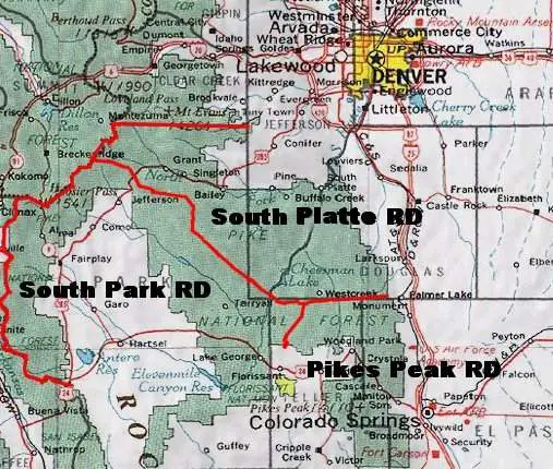
The Pike National Forest encompasses approximately 1.2 million acres spread across Park, Jefferson, Douglas, Teller, and El Paso Counties in central Colorado. Because of its close proximity to both Denver and Colorado Springs, the Pike National Forest is one of the busiest forests in the region, boasting an annual visitation average of nearly 2.5 million people. The South Platte Ranger District is responsible for 450,000 acres of the Pike National Forest, covering the entirety of southern Jefferson County, western Park County, and western Douglas County. Two other Ranger Districts manage the forest, Pikes Peak to the south, covering the portions of the forest in Teller and El Paso Counties, and the South Park Ranger District, covering the remaining portions of the forest which ring Park County. The Pike National Forest is managed jointly with the San Isabel National Forest and the Cimarron and Comanche National Grasslands.
Contents
Radio Frequencies
The Pike National Forest is managed jointly with the San Isabel National Forest and the Cimarron and Comanche National Grasslands. Unlike the unified Arapahoe, Roosevelt, Pawnee radio system to the north, geographic disparities keep the operations of the PSICC radio systems separate, with each management unit operating their own net.
- Information for the San Isabel National Forest Radio Network can be found here: San Isabel National Forest
- Information for the Cimarron and Comanche National Grasslands Radio Network can be found here: Cimarron and Comanche National Grasslands
Dispatching and resource tracking on the Pike National Forest is handled by the Pueblo Interagency Dispatch Center.
- WildCAD CO-PBC Local Incident and Resource Status Tracking
- Federal Dispatch Boundary Maps for Colorado
- Pike, San Isabel, Comanche, and Cimmarron Response Area Maps
Pike National Forest Repeater Network (Pike Net)
- Frequencies changed in July 2016 to comply with NTIA directive to move repeater outputs to frequencies between 169.5125 and 173.9875.
- 2025 Reports that 171.1375 may have migrated to 173.1875
- "Tone #" refers to the Standard Tone Numbering System used by the USFS, BLM, and other land management agencies and is only applicable to TX tones.
| CH | TONE # | RX FREQ | RX TONE | TX FREQ | TX TONE | Description | Ranger District | County | Confirmation |
|---|---|---|---|---|---|---|---|---|---|
| "Local" (Direct) | 1 | 171.1375 | 110.9 | 171.1375 | 110.9 | Forest-wide Simplex/Direct | (All) | (All) | 2022.07 |
| North Twin Cone | 2 | 171.1375 | 110.9 | 164.9875 | 123.0 | North Twin Cone Peak Repeater | S Platte / S Park | Park | |
| Russell Ridge | 3 | 171.1375 | 110.9 | 164.9875 | 131.8 | Russell Ridge (Indian Creek) Repeater | S Platte | Jefferson | 2022.07 |
| Mount Evans | 4 | 171.1375 | 110.9 | 164.9875 | 136.5 | Mount Evans Repeater | S Platte | Clear Creek | 2022.07 |
| Longwater Gulch | 5 | 171.1375 | 110.9 | 164.9875 | 146.2 | Longwater Gulch (Green Mountain) Repeater | S Platte / S Park / Pikes Peak | Douglas | 2022.07 |
| Devils Head | 6 | 171.1375 | 110.9 | 164.9875 | 156.7 | Devil's Head Repeater | S Platte | Douglas | 2022.07 |
| Almagre | 7 | 171.1375 | 110.9 | 164.9875 | 167.9 | Almagre Mountain Repeater | Pikes Peak | Teller | 2022.07 |
| Stanley | 8 | 171.1375 | 110.9 | 164.9875 | 103.5 | Stanley Canyon Repeater | Pikes Peak | El Paso | |
| Cheyenne Creek | 9 | 171.1375 | 110.9 | 164.9875 | 100.0 | Cheyenne Creek (Mount Rosa) Repeater | Pikes Peak | El Paso | |
| Lake George | 10 | 171.1375 | 110.9 | 164.9875 | 107.2 | Lake George Repeater | S Park | Park | 2021.09 |
| Topaz | 11 | 171.1375 | 110.9 | 164.9875 | 114.8 | Topaz Mountain Repeater | S Platte / S Park | Park | 2022.07 |
| Dicks Peak | 12 | 171.1375 | 110.9 | 164.9875 | 127.3 | Dicks Peak Repeater | S Park | Park | |
| Sheep Ridge | 13 | 171.1375 | 110.9 | 164.9875 | 141.3 | Sheep Ridge (Sacramento Gulch) Repeater | S Park | Park | |
| Bailey | 14 | 171.1375 | 110.9 | 164.9875 | 151.4 | Mount Bailey Repeater | S Platte / S Park | Park | 2022.01 |
| Badger | 15 | 171.1375 | 110.9 | 164.9875 | 162.2 | Badger Mountain Repeater | S Park | Park | 2022.06 |
| 16 | 171.1375 | 110.9 | 164.9875 | 192.8 | Portable Repeater | (Incident specific) | (Incident specific) | ||
| (UHF Link) | 406.3250 | (Varies) | 415.3250 | (Varies) | UHF Remote Link to Pike Repeater Net (Tones vary depending upon repeater selected) |
Intra-Crew, Work, & Tactical Frequencies
- Pike NF has no (known) exclusive frequency assignments for either work or tactical use. All of Pike's work and tactical channels are shared use, either within the USFS or across the entire Federal Government. Beware that communications from other Federal agencies or forest units may be received on any/all of these frequencies depending on your location, as their use is not specific to Pike NF.
- Work Channels/frequencies are generally restricted to low power use in handhelds for the purpose of intra-crew communications. These frequencies are part of a shared NTIA Itinerant/Common Use pool (see: Federal Government Itinerant) and not reserved for use by any one specific user/agency.
- The three known Pike Tactical channels are shared use within USFS as nationwide NIFC Tacs and not specifically assigned to Pike NF. See National Incident Radio Support Cache for additional.
- On extended attack incidents, frequencies from the National Incident Radio Support Cache pool are likely to be assigned.
- Local/initial attack incidents may be assigned frequencies from the VHF portion of the NIFOG Interoperability pool (see: Common Public Safety#VHF High Band) to allow for direct coordination with local resources.
| CH | RX FREQ | RX TONE | TX FREQ | TX TONE | Description | Notes | Confirmation |
|---|---|---|---|---|---|---|---|
| TAC 1 | 168.050 | CSQ | 168.050 | CSQ | Pike TAC 1 (NIFC TAC 1) | In common use nationwide as NIFC TAC 1, in use by PSF as an IA (Initial Attack) tactical frequency. Limited to mobile/handheld simplex use only. Not exclusively assigned to Pike NF. Has been referred to as "Group 5 Tac 1" by Pike NF personnel. | 2022.06 (In use on Gove Creek incident.) |
| TAC 2 | 168.200 | 168.200 | Pike TAC 2 (NIFC TAC 2) | In common use nationwide as NIFC TAC 2, in use by PSF as an IA (Initial Attack) tactical frequency. Limited to mobile/handheld simplex use only. Not exclusively assigned to Pike NF. Has been referred to as "Group 5 Tac 2" by Pike NF personnel. | 2022.06 (In use on Gove Creek incident.) | ||
| TAC 3 | 168.600 | 168.600 | Pike TAC 3 (NIFC TAC 3) | In common use nationwide as NIFC TAC 3, in use by PSF as an IA (Initial Attack) tactical frequency. Limited to mobile/handheld simplex use only. Not exclusively assigned to Pike NF. Has been referred to as "Group 5 Tac 3" by Pike NF personnel. | |||
| "Pike Work" | 163.7125 | 163.7125 | (Varies) | Pike Work Ch 1 | Gov't Common 1, handheld or mobile use only. National Travel Net, IHC, and Intra-Crew frequency. Tones 192.8 and 110.9 have been reported in use by Pike on this frequency. | 2022.07 (Briefly heard maintenance or recreation personnel calling on "Work 1." Unknown if ARF or PSF personnel). | |
| "Work-2" | 168.6125 | 168.6125 | (Varies) | Pike Work Ch 2 | Gov't Common 3, handheld or mobile use only. Secondary IHC and Intra-Crew frequency. Tones 103.5 and 110.9 have been reported in use by Pike on this frequency. | 2022.07 (In use by REC units performing trail work using "Tone 8" (103.5). | |
| "Gov Work" | 168.350 | 168.350 | "Government Work" Inter-agency Work Ch | Gov't Common/Nationwide Itinerant. Can be used as an input to 163.100 for portable or temporary repeaters. Old National Travel Net and R-2 TAC. In common use by BLM as a Local Work Channel. | |||
| 163.100 | 163.100 | General Use Work/TAC Ch | Gov't Common/Nationwide Itinerant. Output to 168.350 when configured for use as a temporary/portable repeater. Old National Logistics Channel. In common use by many Federal agencies as a travel channel. |
Law Enforcement
- The Pueblo Interagency Dispatch Center (Pueblo Dispatch) does not handle any LE dispatching functions. USFS LEO's in Colorado generally use either the State (CSP) communications center, or the local County Sheriff's dispatch center which covers the area they are working in for dispatch.
- USFS LEO's working in the Rampart Range area of the South Platte Ranger District appear to be using DCSO for dispatch.
| CH | RX FREQ | RX TONE | TX FREQ | TX TONE | Description | Notes | Confirmation |
|---|---|---|---|---|---|---|---|
| "Devil's Head LEO" | 172.5125 | 110.9 | Unknown | Devil's Head Law Enforcement Repeater | Rampart Range Area Law Enforcement Operations Repeater. Very informal tactical use among USFS, DCSO, and CPW LEO's. Appears to be a standalone repeater, not monitored by Pueblo Dispatch. Douglas County dispatch does have access to this repeater and may use it in extremely rare instances to contact DCSO deputies working on calls in the forest. | 2022.07 | |
| "FS Law" | 168.025 | CSQ | 168.025 | CSQ | USFS Nationwide Law Enforcement Simplex Common | Used occasionally for car-to-car comms between LE units on Pike NF. Often used by units when traveling on area highways. | 2022.06 |
In addition to the conventional VHF frequencies shown above, the USFS has been assigned a handful of talkgroups on the State of Colorado DTRS. "USFS SE" has been used in the past by Pike NF LE units for car-to-car traffic, although traffic is more common on the VHF frequencies. Capturing traffic on these talkgroups is extremely difficult, due to the low saturation of USFS units with DTRS radios affiliating to the system.
| Name | TGID | Description | Notes |
|---|---|---|---|
| USFS STW | 1230 | US Forest Service Statewide | Statewide common/travel channel for USFS units in Colorado. |
| USFS NE | 1231 | US Forest Service Northeast Operations | Reserved for Arapaho, Roosevelt, and Pawnee operations. |
| USFS SE | 1232 | US Forest Service Southeast Operations | Reserved for Pike, San Isabel, and Cimmaron/Comanche operations. Has been referred to on-air as "Southeast." |
| USFS NW | 8375 | US Forest Service Northwest Operations | Reserved for Routt-Medicine Bow and White River operations. |
| USFS SW | 8376 | US Forest Service Southwest Operations | Reserved for Grand Mesa-Uncompahgre-Gunnison (GMUG), Rio Grande, and San Juan operations. |
Air Operations
- Additional information available here: National Incident Radio Support Cache #Air VHF FM ("Foxtrot Mike") Frequencies
- The VHF High Band NIFOG frequencies are often used to coordinate air operations with local agencies. V-FIRE21 in particular is often used for Air-Ground operations with local fire departments in the front range. Please see Common Public Safety#VHF High Band for more information.
| CH | RX FREQ | RX TONE | TX FREQ | TX TONE | Description | Notes | Confirmation |
|---|---|---|---|---|---|---|---|
| "National" (NTL FLTF) | 168.650 | 110.9 | 168.650 | 110.9 | National Flight Following Frequency | Nationwide Flight Following Frequency. Used for dispatch, flight following, and/or redirection of aircraft or other air-to-ground administrative traffic. Not for incident or ground operations use. It appears on most radios as "NTL FLTF." Generally referred to on-air as "National." Previously known as "Airnet." | 2024.08 (in use daily with both PBC and FTC dispatch) |
| "AIRGUARD" | 168.625 | 110.9 | 168.625 | 110.9 | National Aircraft Emergency Frequency | Continuous monitoring of this frequency is required of all tactical aircraft and dispatch offices. Restricted to emergency air-to-air or air-to-ground communications only. It may be used for initial call, recall, and redirection of aircraft only if no other frequencies are available. It appears on all radios as "AIRGUARD" and generally as Channel 16 in portable radios to allow crews to switch to it quickly. | 2021.12 (Used briefly as a contact frequency during the Oak Fire.) |
| "Air-Ground 35" | 167.225 | CSQ | 167.225 | CSQ | Colorado Zone 07 Primary Air-Ground | Primary Air-Ground frequency for Pueblo Dispatch Zone (Colorado Initial Attack Zone 07). National Air-Ground System Channel 35. Has been seen programmed as "CO07AG35" or "A/G 35" in some radios. | 2022.07 (In use on Snow Creek Fire.) |
| "Air-Ground 10" | 166.9375 | CSQ | 166.9375 | CSQ | Colorado Zone 07 Secondary Air-Ground | Secondary Air-Ground frequency for Pueblo Dispatch Zone (Colorado Initial Attack Zone 07). National Air-Ground System Channel 10. Has been seen programmed as "CO07AG10" or "A/G 10" in some radios. | 2024.08 (In use during operations on the Quarry Fire.) |
| "Victor 121.075" | 121.075 | AM | 121.075 | AM | Colorado Zone 07 Air-Air 1 | Primary Air-Air frequency for Pueblo Dispatch Zone (Colorado Initial Attack Zone 07). Referred to on-air as "Victor" or "Victor 121.075." | 2022.07 (In use during operations on the Snow Creek Fire). |
| 119.575 | AM | 119.575 | AM | Colorado Zone 07 Air-Air 2 | Secondary Air-Air frequency for Pueblo Dispatch Zone (Colorado Initial Attack Zone 07). | 2024.08 Used during the Quarry Fire. | |
| 126.350 | AM | 126.350 | AM | Colorado Zone 07 Air-Air 3 | Tertiary Air-Air frequency for Pueblo Dispatch Zone (Colorado Initial Attack Zone 07). Authorized for use during 2020 season, unknown if still in use. | ||
| 120.925 | AM | 120.925 | AM | Helo Deconflict | Rotorwing deconfliction operations | 2024.07 Used during the Quarry Fire. | |
| (UHF Link) | 408.9875 | 136.5 | 417.9875 | 110.9 | UHF Remote Link to National Flight Following (168.650) |
Operations
Station Locations / Ranger Districts
The Pueblo Interagency Dispatch Center has elected to assign station numbers to the work centers and district offices in their service area. These aliases are used when communicating with Pueblo Dispatch to describe the locations where personnel and apparatus are quartered. For Forest Service "stations," the station numbers correspond directly to the assigned district number for that particular Ranger District. Some stations may encompass several physical locations spread out across a given district. In these instances the station number is generally used to describe the resources of that particular Ranger District, and not necessarily a specific location. For stations arranged in this manner, the specific name of the work center or facility is usually given when communicating a unit status with Pueblo Dispatch. Forest Service Ranger Districts generally follow the watershed boundaries of their given territories, often causing them to cross county lines and other political boundaries. Please note that, due to the consolidation of several Ranger Districts over the years, there are some numbers which have been skipped.
| Station No. | Management Unit | Ranger District | Location(s) |
|---|---|---|---|
| Station 1 | San Isabel Nat'l Forest (CO-PSF) | Leadville Ranger District | 810 Front St., Leadville, CO 80461 |
| Station 2 | San Isabel Nat'l Forest (CO-PSF) | Salida Ranger District | 5575 Cleora Rd., Salida, CO 81201 |
| Station 3 | San Isabel Nat'l Forest (CO-PSF) | San Carlos Ranger District | 3028 East Main St., Canon City, CO 81212 |
| Station 4 | Bureau of Land Management (CO-RMD) | Rocky Mountain District | Royal Gorge Field Office: 3028 E. Main St., Canon City, CO 81212 [1]
San Luis Valley Field Office: 1313 E HWY 160, Monte Vista, CO 81144 |
| Station 6 | Comanche Nat'l Grassland (CO-PSF) | Springfield Ranger District | Carrizo Unit: 27204 US HWY 287, Springfield, CO 81073
Timpas Unit: 1420 E. 3rd St., La Junta, CO 81050 |
| Station 7 | Cimarron Nat'l Grassland (CO-PSF) | Elkhart Ranger District | 242 E HWY 56, Elkhart, KS 67950 |
| Station 9 | Pike Nat'l Forest (CO-PSF) | Pike's Peak Ranger District | Woodland Park Work Center: 1408 Rampart Ranger Rd., Woodland Park, CO 80863
Monument Fire Center: 3751 Mt. Herman Rd., Monument, CO 80132 [2] |
| Station 10 | Pike Nat'l Forest (CO-PSF) | South Park Ranger District | District Office: 320 HWY 285, Fairplay, CO 80440
Lake George Work Center: 140 Trail Creek Rd., Lake George, CO 80827 |
| Station 11 | Pike Nat'l Forest (CO-PSF) | South Platte Ranger District | Buffalo Creek Work Center: 18046 CR 126, Pine, CO 80425 |
[1]: The BLM's Royal Gorge Field Office is co-located with the San Carlos Ranger District Office.
[2]: The Monument Fire Center is the Headquarters for the Pike Interagency Hotshot Crew (IHC).
Response Areas
The Pueblo Interagency Dispatch Center has sub-divided the individual Ranger Districts of the Pike National Forest into geographic "Response Areas." These areas are identified by a numeric code, usually (but not always) beginning with the ranger district/station number. Units in the field will often provide Pueblo Dispatch with these numeric location codes when updating their statuses or locations throughout the day.
Station 9 - Pikes Peak Ranger District
| Response Area | Area Name | Management Unit | Ranger District | County | Cooperator Fire Districts |
|---|---|---|---|---|---|
| 90 | Seven Lakes | CO-PSF | Pikes Peak | Teller | N/A |
| 90E | Pikes Peak | CO-PSF | Pikes Peak | El Paso / Teller | Cascade / Green Mtn. Falls-Chip Park / NE Teller / Divide |
| 90M | Broadmoor | CO-PSF | Pikes Peak | El Paso | Broadmoor / Colorado Springs |
| 90W | Gillett | CO-PSF | Pikes Peak | Teller | Divide / Four Mile / Cripple Creek / Victor |
| 91 | Rampart Reservoir | CO-PSF | Pikes Peak | El Paso | Cascade / Green Mtn. Falls-Chip Park |
| 91M | Garden of the Gods | CO-PSF | Pikes Peak | El Paso | Woodmen Valley / USAFA / Colorado Springs / Tri-Lakes Monument |
| 92E | Chimney Peak | CO-PSF | Pikes Peak | Douglas / El Paso | N/A |
| 92M | Spruce Mountain | CO-PSF | Pikes Peak | Douglas | Larkspur / Tri-Lakes Monument |
| 92W | Manitou Experimental Forest | CO-PSF | Pikes Peak | Douglas / Teller / El Paso | NE Teller / Mountain Communities |
| 93 | Signal Butte | CO-PSF | Pikes Peak | Douglas / Teller | NE Teller / Divide / Mountain Communities |
Station 10 - South Park Ranger District
| Response Area | Area Name | Management Unit | Ranger District | County | Cooperator Fire Districts |
|---|---|---|---|---|---|
| 10 | Lake George | CO-PSF | South Park | Park | Lake George / Hartsel |
| 10A | Stoll Mountain | CO-PSF | South Park | Park | Lake George / Hartsel |
| 10N | Hackett Gulch | CO-PSF | South Park | Park | Lake George / Mountain Communities / Florissant |
| 10P | Florissant Fossil Beds-NPS | CO-PSF / CO-FFP | South Park | Teller | Florissant / Divide |
| 10S | Four Mile | CO-PSF | South Park | Park / Teller | Southern Park County / Four Mile |
| 11 | Thirtynine Mile Mountain | CO-PSF | South Park | Park | Southern Park County / Hartsel |
| 12 | Dicks Peak | CO-PSF | South Park | Park | Southern Park County / Hartsel |
| 13 | Badger Flats | CO-PSF | South Park | Park | Lake George |
| 13A | Puma Hills | CO-PSF | South Park | Park | Lake George / Hartsel |
| 14 | Northern Tarryall | CO-PSF | South Park | Park | Jefferson-Como |
| 14A | Farnum Peak | CO-PSF | South Park | Park | Jefferson-Como / Hartsel / Lake George |
| 15 | Topaz Mountain | CO-PSF | South Park | Park | Jefferson-Como |
| 16 | Lost Creek Wilderness West | CO-PSF | South Park | Park | Jefferson-Como / Lake George |
| 17 | Georgia Pass | CO-PSF | South Park | Park | Northwest / Jefferson-Como |
| 18 | Sacramento | CO-PSF | South Park | Park | Northwest / Hartsel |
| 19 | Jones Hill | CO-PSF | South Park | Park | Hartsel / Northwest |
| 19N | Reinecker Ridge | CO-PSF | South Park | Park | Northwest / Jefferson-Como / Hartsel |
| 19S | South Highway 9 | CO-PSF | South Park | Park | Hartsel |
| 19SE | Spinney | CO-PSF | South Park | Park | Hartsel |
| 19SW | Antero | CO-PSF | South Park | Park | Hartsel |
| 19W | Buffalo Peaks Wilderness | CO-PSF | South Park | Park | Northwest |
Station 11 - South Platte Ranger District
| Response Area | Area Name | Management Unit | Ranger District | County | Cooperator Fire Districts |
|---|---|---|---|---|---|
| 1101 | Sawmill Gulch | CO-PSF | South Platte | Park | Platte Canyon |
| 1102 | Mt. Evans Wilderness | CO-PSF | South Platte | Park | Platte Canyon |
| 1102A | Mt. Evans Wilderness-ARF | CO-ARF | Clear Creek | Park | Platte Canyon |
| 1103 | Harris Park | CO-PSF | South Platte | Park | Platte Canyon / Elk Creek |
| 1103A | Cub Creek-ARF | CO-ARF | Clear Creek | Park / Jefferson | Elk Creek / Evergreen |
| 1104 | Buffalo Creek | CO-PSF | South Platte | Jefferson | North Fork |
| 1105 | Indian Creek | CO-PSF | South Platte | Jefferson | West Douglas / Forest Service |
| 1106 | Lost Creek Wilderness | CO-PSF | South Platte | Park / Jefferson | Platte Canyon / Jefferson-Como |
| 1106E | N. Terryall / Kenosha | CO-PSF | South Platte | Park | Platte Canyon / North Fork |
| 1107 | Cheeseman Lake | CO-PSF | South Platte | Jefferson / Douglas / Teller | North Fork / Mountain Communities / Lake George |
| 1108 | Polhemus Gulch | CO-PSF | South Platte | Jefferson | North Fork / Mountain Communities / Forest Service |
Unit Identifiers
Unit identifiers for personnel and apparatus operating on the Pike National Forest generally follows the "Function-District-Position" format in use nationally. In this format, units will identify themselves first by their function (such as "Engine" or "Module") followed by the ranger district number (see Stations list) and then followed by their unique identifier or a position number (example: "Engine 11-1" would correspond to an engine assigned to the South Platte District). Resources from other agencies or from other forest units will generally identify themselves using their own callsigns prefaced by the outside agency name, the outside forest unit's name, or the home location of the unit (example: "North Fork 1201," or "Minnesota Engine 621"). Visiting units may sometimes use the older style four digit numeric identifiers which follow the Forest-District-Function format. These identifiers lead off with the numeric code for the forest unit, followed by the district number, and then by the individual units function code (resources, fire management, ect). These callsigns are still in use by other Forest Service Regions, but rarely encountered on the Pike National Forest. Many forest service engines from outside the Pike (such as those based on the Arapahoe-Roosevelt National Forest to the north) will use three digit identifiers, with the first digit signifying the type of engine, the next digit signifiyng the zone or district, and the last a unique identifier. Personnel not attached to a unit or without an assigned callsign use their last name to identify themselves on the radio.
Apparatus markings for the Pike National Forest are compliant with NWCG PMS 931 Standards for Unit Identifiers and are easily distinguishable by their unique Unit Identifier Code when operating in the field or on an incident (CO-PSF).
| Identifier | Description | Notes |
|---|---|---|
| "Chief" | Forest Fire Management Officer (FFMO) / Assistant Forest Fire Management Officer (AFFMO) | |
| "Division" | District / Zone Fire Management Officer | |
| "Battalion" | District / Zone Asst. Fire Management Officer | |
| "Captain" | Squad / Engine Supervisor | |
| "Squad" | Initial Attack / Fuels Management Squad | |
| "Patrol" | Patrol Unit | (A patrol truck equipped with water, usually a Type VII light wildland engine.) |
| "Prevention" | Prevention Unit | (A patrol truck not equipped with water.) |
| "Engine" | Wildland Fire Engine | (Any ground vehicle used principally for tactical wildland firefighting, used to deploy water on a fire using pump and hose. Structural engines are Types I and II, heavy wildland engines are Types III, IV, and V, and light wildland engines are types VI, and VII.) |
| "Dozer" | Wildland Fire Dozer | (A tracked vehicle with front mounted blade used for exposing mineral soil to construct fireline or firebreaks.) |
| "MOD" | Engine / Fuels Management Module | |
| "REC" | Recreation Technician | (Performs resource management activities such as maintenance of recreation facilities and trails, leading work crews, patrolling forest areas, and assisting in suppression of wildland fires. May be qualified to enforce forest rules and regulations as a Forest Protection Officer.) |
| "FS-##" | Law Enforcement & Investigations |