Difference between revisions of "Tulsa International Airport (TUL) Tulsa County (OK)"
From The RadioReference Wiki
m (InfoBox) |
Andy51edge (talk | contribs) m (→Delta Airlines: Correcting Delta Air Lines Name (Space between Air and Lines)) |
||
| (19 intermediate revisions by 3 users not shown) | |||
| Line 7: | Line 7: | ||
|State=[[Oklahoma (US)|Oklahoma]] | |State=[[Oklahoma (US)|Oklahoma]] | ||
|state=oklahoma | |state=oklahoma | ||
| − | |TRACON= | + | |TRACON=[[#Terminal Radar Approach Control (TRACON)|Tulsa]]<sup>[https://www.faa.gov/about/office_org/headquarters_offices/ato/service_units/air_traffic_services/tracon/ [ref]]</sup> |
| − | |ARTCC=[[Kansas City (ZKC) Air Route Traffic Control Center | + | |ARTCC=[[Kansas City (ZKC) Air Route Traffic Control Center|Kansas City]] |
|DBtype=a | |DBtype=a | ||
|DBid=1331 | |DBid=1331 | ||
| Line 15: | Line 15: | ||
==Tulsa International Airport (KTUL) Air Traffic Control== | ==Tulsa International Airport (KTUL) Air Traffic Control== | ||
| − | {| | + | <gallery> |
| + | Image:Tulsa Approach Frequencies.jpg|Tulsa Approach Frequencies | ||
| + | Image:KTUL Runway Freq Map.jpg|250px|thumb|Tulsa Airport Diagram | ||
| + | </gallery> | ||
| + | {| class="rrtable sortable" | ||
!VHF Frequency | !VHF Frequency | ||
!UHF Frequency | !UHF Frequency | ||
!Area of Control | !Area of Control | ||
!Callsign | !Callsign | ||
| + | !Note | ||
| + | |- | ||
| + | |121.20 | ||
| + | |310.80 | ||
| + | |Runways 36R/18L and 8/26 | ||
| + | |Tulsa Tower | ||
| + | |Primary Local frequency that is used by all aircraft during times of low traffic | ||
|- | |- | ||
|118.70 | |118.70 | ||
|257.80 | |257.80 | ||
|Runway 36L/18R | |Runway 36L/18R | ||
| − | |||
| − | |||
| − | |||
| − | |||
| − | |||
|Tulsa Tower | |Tulsa Tower | ||
| + | |Combined with 36R/18L and 8/26 frequency (121.2/310.0) during times of low traffic | ||
|- | |- | ||
|121.90 | |121.90 | ||
| Line 35: | Line 42: | ||
|Taxiways | |Taxiways | ||
|Tulsa Ground | |Tulsa Ground | ||
| + | | | ||
|- | |- | ||
|134.05 | |134.05 | ||
|284.70 | |284.70 | ||
| − | | | + | | |
|Tulsa Clearance Delivery | |Tulsa Clearance Delivery | ||
| + | | | ||
|- | |- | ||
|124.90 | |124.90 | ||
|377.20 | |377.20 | ||
| − | | | + | | |
|Automated Terminal Information System (ATIS) | |Automated Terminal Information System (ATIS) | ||
| + | | | ||
|} | |} | ||
| − | == | + | ==Terminal Radar Approach Control (TRACON)== |
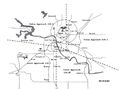
| − | [[File:Tulsa Airspace Map.jpg| | + | [[File:Tulsa Airspace Map.jpg|250px|thumb|Tulsa Riverside Tower Pilot Information Handbook Excerpt]] |
| − | {| | + | {| class="rrtable sortable" |
!VHF Frequency | !VHF Frequency | ||
!UHF Frequency | !UHF Frequency | ||
!Area of Control | !Area of Control | ||
!Callsign | !Callsign | ||
| + | !Note | ||
|- | |- | ||
|124.00 | |124.00 | ||
|338.30 | |338.30 | ||
|Northwest sector | |Northwest sector | ||
| − | |Tulsa Approach | + | |Tulsa Approach and Tulsa Departure |
| + | |Primary frequency | ||
|- | |- | ||
|119.10 | |119.10 | ||
|351.80 | |351.80 | ||
| − | |East sector | + | |North East sector |
| − | |Tulsa Approach | + | |Tulsa Approach and Tulsa Departure |
| + | |Combined with Northwest Sector during times of low traffic | ||
|- | |- | ||
|134.70 | |134.70 | ||
|n/a | |n/a | ||
|Southwest sector | |Southwest sector | ||
| − | |Tulsa Approach | + | |Tulsa Approach and Tulsa Departure |
| + | |Combined with Northwest sector (124.00/338.30) during times of low traffic | ||
|- | |- | ||
|119.85 | |119.85 | ||
|381.20 | |381.20 | ||
| − | | | + | |Southwest Sector |
| − | |Tulsa Approach | + | |Tulsa Approach and Tulsa Departure |
| + | |Combined with Southwest Sector (134.70) 99% of time | ||
|- | |- | ||
|132.10 | |132.10 | ||
|319.90 | |319.90 | ||
| − | | | + | |Tulsa Inner Class C |
| − | |Tulsa Approach | + | |Tulsa Approach and Tulsa Departure |
| + | |Used to provide Airport Surveillance Radar (ASR) approaches. | ||
| + | |} | ||
| + | Information listed above is inconsistent between the KTUL and KRVS airport files. KTUL lists 119.85 as a final approach frequency and makes no mention of 134.70. KRVS lists 119.85 as the TRACON to the east of the airport. The information above is based off of the Tulsa Riverside Tower Pilot Information Handbook airspace map. | ||
| + | |||
| + | |||
| + | ==Airline Operations== | ||
| + | ===American Airlines=== | ||
| + | Tulsa International Airport is the Global Maintenance Headquarters of American Airlines. | ||
| + | <freqsubcat>14552</freqsubcat> | ||
| + | Further information on the Maintenance Headquarters radio use is found [[American Airlines Tulsa Maintenance Base]]. This is part of the search for frequencies. | ||
| + | |||
| + | ===Delta Air Lines=== | ||
| + | <freqsubcat>19760</freqsubcat> | ||
| + | |||
| + | ===FedEx=== | ||
| + | <freqsubcat>56901</freqsubcat> | ||
| + | ===Frontier Airlines=== | ||
| + | Frontier Airlines has been granted the license [https://www.radioreference.com/apps/db/?fccCallsign=WQGU734 WQGU734] with airline service scheduled to commence in [http://www.newson6.com/story/35912863/frontier-to-add-nonstop-flights-from-tulsa-to-denver-orlando-and-san-diego spring 2018]. | ||
| + | The following frequency pair is a prediction based off of the license listed above | ||
| + | {| class="rrtable" | ||
| + | !Frequency | ||
| + | !Input | ||
| + | !License | ||
| + | !Type | ||
| + | !Tone | ||
| + | !Alpha Tag | ||
| + | !Description | ||
| + | !Mode | ||
| + | !Tag | ||
| + | |- | ||
| + | |''463.9625'' | ||
| + | |''468.9625'' | ||
| + | |''[https://www.radioreference.com/apps/db/?fccCallsign=WQGU734 WQGU734]'' | ||
| + | |''RM'' | ||
| + | | | ||
| + | |''FFT Ground Ops'' | ||
| + | |''Frontier Airlines Ground Operations'' | ||
| + | | | ||
| + | |''Business'' | ||
| + | |} | ||
| + | ===Southwest Airlines=== | ||
| + | <freqsubcat>14553</freqsubcat> | ||
| + | ===United Airlines=== | ||
| + | <freqsubcat>20008</freqsubcat> | ||
| + | ===ACARS=== | ||
| + | There is an [[ACARS]] remote sounding on the airport. With the following licenses associated with it: [http://www.radioreference.com/apps/db/?fccCallsign=KXI5 KXI5], [http://www.radioreference.com/apps/db/?fccCallsign=KGP2 KGP2], [http://www.radioreference.com/apps/db/?fccCallsign=WQJR360 WQJR360], and [http://www.radioreference.com/apps/db/?fccCallsign=WCJ91 WCJ91] | ||
| + | {|class="rrtable sortable" | ||
| + | !Frequency | ||
| + | |- | ||
| + | |129.525 | ||
| + | |- | ||
| + | |130.025 | ||
| + | |- | ||
| + | |131.550 | ||
| + | |- | ||
| + | |131.725 | ||
| + | |- | ||
| + | |136.975 | ||
|} | |} | ||
| − | == | + | ==Tulsa Air National Guard== |
| − | * [[North American Aerospace Defense Command (NORAD)]] | + | The Tulsa Air National Guard Base (TANGB) is Co-located at Tulsa International Airport and operates a fleet of F-16 Fighting Falcons. TANGB is host to the 138th Fighter Wing. The 125th Fighter Squadron is part of the 138th Fighter Wing. |
| + | |||
| + | For ATC services, the F-16s normally operate on the UHF air traffic control frequencies. Though the controllers will normally transmit on both VHF and UHF frequencies simultaneously, so the ATC side of the transmissions can normally be heard on VHF. | ||
| + | ===Base Operations=== | ||
| + | <freqsubcat>47258</freqsubcat> | ||
| + | ===Air to Air Operations=== | ||
| + | <freqsubcat>47259</freqsubcat> | ||
| + | |||
| + | ==Tulsa Airport Authority== | ||
| + | The Tulsa Airport Authority (TAA) uses [[OKWIN|OKWIN's]] Tulsa Site for most day to day operations. TAA is migrating from Motorola to a P25 system. | ||
| + | |||
| + | TAA has its own police force that uses the TAA channel F (P25 TG: 2219, MOT TG: 35504). | ||
| + | ===P25 System=== | ||
| + | <tg>6949|24313</tg> | ||
| + | ===Motorola=== | ||
| + | <tg>844|11747</tg> | ||
| + | |||
| + | ==See Also== | ||
| + | *[[Airports Tulsa County (OK)]] | ||
| + | *[[Tulsa County (OK)]] | ||
| + | *[[North American Aerospace Defense Command (NORAD)]] | ||
| + | *[[Federal Aviation Administration]] | ||
| + | *[[Transportation Security Administration]] | ||
| + | *[[ACARS]] | ||
| + | *[[OKWIN]] | ||
| + | |||
| + | ==External Links== | ||
| + | *[https://www.faa.gov/about/office_org/headquarters_offices/ato/service_units/air_traffic_services/tracon/ TRACON List] | ||
| + | *[http://jraa.org/resourcesforourmembers/pilothandbook.html Tulsa Riverside Tower Pilot Information Handbook] | ||
| + | |||
| + | |||
[[Category:Oklahoma Civil Aviation]] | [[Category:Oklahoma Civil Aviation]] | ||
Latest revision as of 02:52, 23 November 2021
| ICAO: | KTUL |
| FAA: | TUL |
| City: | Tulsa |
| County: | Tulsa |
| State: | Oklahoma |
| TRACON: | Tulsa[ref] |
| ARTCC: | Kansas City |
|
| |
| Database | AirNav |
| Forum | FlightAware |
|
| |
| Aviation FAQ | Aviation Glossary |
|
| |
| Wiki FAQ | MediaWiki |
| QuickRef | PDF Card |
Welcome to the Tulsa International Airport (TUL) aviation article, the airport located in Tulsa County, Oklahoma.
This is where you, the user, may index any articles, frequencies-lists, etc. that you develop for scanning related topics for this airport.
Contents
Tulsa International Airport (KTUL) Air Traffic Control
Tulsa Approach Frequencies
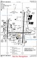
Tulsa Airport Diagram


| VHF Frequency | UHF Frequency | Area of Control | Callsign | Note |
|---|---|---|---|---|
| 121.20 | 310.80 | Runways 36R/18L and 8/26 | Tulsa Tower | Primary Local frequency that is used by all aircraft during times of low traffic |
| 118.70 | 257.80 | Runway 36L/18R | Tulsa Tower | Combined with 36R/18L and 8/26 frequency (121.2/310.0) during times of low traffic |
| 121.90 | 348.60 | Taxiways | Tulsa Ground | |
| 134.05 | 284.70 | Tulsa Clearance Delivery | ||
| 124.90 | 377.20 | Automated Terminal Information System (ATIS) |
Terminal Radar Approach Control (TRACON)

| VHF Frequency | UHF Frequency | Area of Control | Callsign | Note |
|---|---|---|---|---|
| 124.00 | 338.30 | Northwest sector | Tulsa Approach and Tulsa Departure | Primary frequency |
| 119.10 | 351.80 | North East sector | Tulsa Approach and Tulsa Departure | Combined with Northwest Sector during times of low traffic |
| 134.70 | n/a | Southwest sector | Tulsa Approach and Tulsa Departure | Combined with Northwest sector (124.00/338.30) during times of low traffic |
| 119.85 | 381.20 | Southwest Sector | Tulsa Approach and Tulsa Departure | Combined with Southwest Sector (134.70) 99% of time |
| 132.10 | 319.90 | Tulsa Inner Class C | Tulsa Approach and Tulsa Departure | Used to provide Airport Surveillance Radar (ASR) approaches. |
Information listed above is inconsistent between the KTUL and KRVS airport files. KTUL lists 119.85 as a final approach frequency and makes no mention of 134.70. KRVS lists 119.85 as the TRACON to the east of the airport. The information above is based off of the Tulsa Riverside Tower Pilot Information Handbook airspace map.
Airline Operations
American Airlines
Tulsa International Airport is the Global Maintenance Headquarters of American Airlines.
| Frequency |
Input |
License | Type | Tone | Alpha Tag | Description | Mode | Tag |
|---|---|---|---|---|---|---|---|---|
| 460.65000 | 465.65000 | WNPC794 | RM | AmericanAirlines | Ground Operations | FMN | Business | |
| 460.80000 | 465.80000 | KNBR346 | RM | AmericanAirlines | Ground Operations | FMN | Business | |
| 129.20000 | WEI5 | BM | CSQ | AmericanAirlines | Air to Ground | AM | Aircraft | |
| 129.32500 | WEI5 | BM | CSQ | AmericanAirlines | Air to Ground Maintenance | AM | Aircraft |
Further information on the Maintenance Headquarters radio use is found American Airlines Tulsa Maintenance Base. This is part of the search for frequencies.
Delta Air Lines
| Frequency |
Input |
License | Type | Tone | Alpha Tag | Description | Mode | Tag |
|---|---|---|---|---|---|---|---|---|
| 460.82500 | 465.82500 | KKO374 | RM | 115 DPL | Delta Airlines | Ground Operations | FMN | Business |
FedEx
| Frequency | License | Type | Tone | Alpha Tag | Description | Mode | Tag |
|---|---|---|---|---|---|---|---|
| 131.92500 | WOM6 | BM | CSQ | FedEx Tulsa Air | FedEx -- Air to Ground | AM | Aircraft |
Frontier Airlines
Frontier Airlines has been granted the license WQGU734 with airline service scheduled to commence in spring 2018. The following frequency pair is a prediction based off of the license listed above
| Frequency | Input | License | Type | Tone | Alpha Tag | Description | Mode | Tag |
|---|---|---|---|---|---|---|---|---|
| 463.9625 | 468.9625 | WQGU734 | RM | FFT Ground Ops | Frontier Airlines Ground Operations | Business |
Southwest Airlines
| Frequency |
Input |
License | Type | Tone | Alpha Tag | Description | Mode | Tag |
|---|---|---|---|---|---|---|---|---|
| 451.48750 | 456.48750 | WPEF932 | RM | 115 DPL | SW Airlines Grnd | Ground Operations | FMN | Business |
| 131.70000 | WPI3 | BM | CSQ | SW Airlines Air | Air to Ground | AM | Aircraft |
United Airlines
| Frequency |
Input |
License | Type | Tone | Alpha Tag | Description | Mode | Tag |
|---|---|---|---|---|---|---|---|---|
| 464.77500 | 469.77500 | WNQZ554 | RM | United Airlines | Ground Operations | DMR | Business | |
| 130.15000 | KNT9 | BM | CSQ | United Airlines | Air to Ground | AM | Aircraft |
ACARS
There is an ACARS remote sounding on the airport. With the following licenses associated with it: KXI5, KGP2, WQJR360, and WCJ91
| Frequency |
|---|
| 129.525 |
| 130.025 |
| 131.550 |
| 131.725 |
| 136.975 |
Tulsa Air National Guard
The Tulsa Air National Guard Base (TANGB) is Co-located at Tulsa International Airport and operates a fleet of F-16 Fighting Falcons. TANGB is host to the 138th Fighter Wing. The 125th Fighter Squadron is part of the 138th Fighter Wing.
For ATC services, the F-16s normally operate on the UHF air traffic control frequencies. Though the controllers will normally transmit on both VHF and UHF frequencies simultaneously, so the ATC side of the transmissions can normally be heard on VHF.
Base Operations
| Frequency | Type | Tone | Alpha Tag | Description | Mode | Tag |
|---|---|---|---|---|---|---|
| 163.51250 | BM | 151.4 PL | Tulsa ANG Ops | TANG Operations | FM | Military |
| 163.48750 | BM | CSQ | ANG Security 1 | Security Primary | FM | Military |
| 164.17500 | BM | CSQ | ANG Security 2 | Security Secondary | FM | Military |
| 163.00000 | BM | CSQ | ANG Fire | Fire and Crash | FM | Military |
| 163.58750 | BM | CSQ | ANG DisasterPrep | Disaster Preparedness | FM | Military |
| 165.06250 | BM | 151.4 PL | Tulsa ANG Ops | TANG Operations | FM | Military |
| 335.47500 | BM | CSQ | Tulsa Air Guard | Air National Guard Operations | AM | Military |
Air to Air Operations
| Frequency | Type | Tone | Alpha Tag | Description | Mode | Tag |
|---|---|---|---|---|---|---|
| 138.42500 | M | CSQ | 138th ANG Air | 125th Flight Squadron -- Air to Air | AM | Military |
| 141.90000 | BM | CSQ | 138th ANGBaseOps | 125th Flight Squadron -- Base Ops | AM | Military |
| 149.35000 | M | CSQ | 138th ANG Air | 125th Flight Squadron -- Air to Air | AM | Military |
| 149.37500 | M | CSQ | 138th ANG Air | 125th Flight Squadron -- Air to Air | AM | Military |
| 149.40000 | M | CSQ | 138th ANG Air | 125th Flight Squadron -- Air to Air | AM | Military |
| 149.45000 | M | CSQ | 138th ANG Air | 125th Flight Squadron -- Air to Air | AM | Military |
| 381.10000 | BM | CSQ | 138th ANG Air | 125th Flight Squadron -- Air to Air | AM | Military |
| 149.62500 | M | CSQ | 138th ANG Air | 125th Flight Squadron - Air to Air | AM | Military |
Tulsa Airport Authority
The Tulsa Airport Authority (TAA) uses OKWIN's Tulsa Site for most day to day operations. TAA is migrating from Motorola to a P25 system.
TAA has its own police force that uses the TAA channel F (P25 TG: 2219, MOT TG: 35504).
P25 System
| DEC | HEX | Mode | Alpha Tag | Description |
|---|---|---|---|---|
| 1981 | 7bd | D | Tulsa Airport H | Airport Traffic Management: |
| 2209 | 8a1 | D | Tulsa Airport A | Airfield Maintenance |
| 2211 | 8a3 | D | Tulsa Airport B | Airport Field Ops |
| 2213 | 8a5 | D | Tulsa Airport C | Airport Building Maintenance |
| 2215 | 8a7 | D | Tulsa Airport D | Riverside Jones Airport |
| 2217 | 8a9 | D | Tulsa Airport E | Airport Tactical |
| 2219 | 8ab | D | Tulsa Airport PD | Airport Police Dispatch (F) |
| 2221 | 8ad | D | Tulsa Airport FD | Airport Fire Dispatch (G) |
Motorola
| DEC | HEX | Mode | Alpha Tag | Description |
|---|---|---|---|---|
| 35344 | 8a1 | A | TulsaAirprtA | Airport Authority A |
| 35376 | 8a3 | A | TulsaAirprtB | Airport Authority B |
| 35408 | 8a5 | A | TulsaAirprtC | Airport Authority C |
| 35440 | 8a7 | A | TulsaAirprtD | Airport Authority D |
| 35472 | 8a9 | A | TulsaAirprtE | Airport Authority E |
| 35504 | 8ab | A | TulsaAirprtF | Police Dispatch and Emergency Alerts |
See Also
- Airports Tulsa County (OK)
- Tulsa County (OK)
- North American Aerospace Defense Command (NORAD)
- Federal Aviation Administration
- Transportation Security Administration
- ACARS
- OKWIN