Difference between revisions of "Indiana Project Hoosier SAFE-T"
From The RadioReference Wiki
| Line 15: | Line 15: | ||
==System Map== | ==System Map== | ||
[https://www.in.gov/ipsc/images/System_Map_Feb_2020.pdf IPSC P25 System Map] | [https://www.in.gov/ipsc/images/System_Map_Feb_2020.pdf IPSC P25 System Map] | ||
| − | + | -Removed by the state for Security Reasons | |
| + | |||
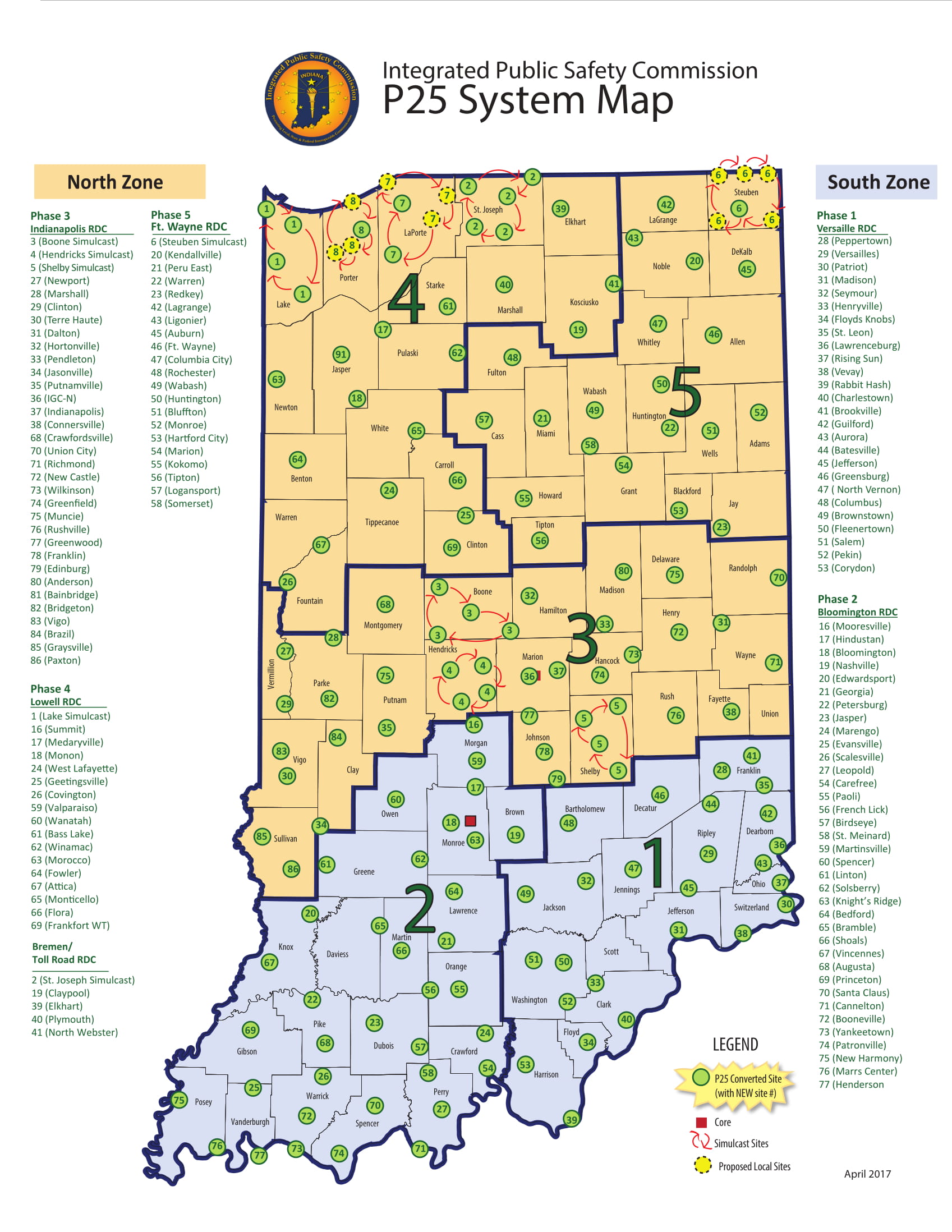
| + | Motorola Provides a map on their [https://www.motorolasolutions.com/en_us/states/indiana.html#maps "system advertisement page"]. Unsure how up-to-date this is. | ||
| + | [https://www.motorolasolutions.com/content/dam/msi/images/states/indianasafet/april_2017_statewide_map.jpg Motorola IPSC Map] | ||
| + | |||
==Related Pages== | ==Related Pages== | ||
* [[Indiana Project Hoosier SAFE-T (P25) RID]] | * [[Indiana Project Hoosier SAFE-T (P25) RID]] | ||
Latest revision as of 08:25, 16 February 2022
| System Name | Indiana Project Hoosier SAFE-T (P25) |
| System Type | Project 25 Phase 1 |
| System ID | 6BD |
| Connect Tone | ? |
| Network Access Code | ? |
| DMR Color Code | ? |
| NXDN RAN | |
| Band | 800 |
| State | IN, KY |
| Ownership | Public |
|
| |
| Indiana Project Hoosier SAFE-T (P25) System DB Entry | |
| Indiana Project Hoosier SAFE-T (P25) Site Map from the RRDB | |
|
| |
| MediaWiki | |
| QuickRef | |
| PDF Card | |
Welcome to the Indiana Project Hoosier SAFE-T (P25) TRS collaboration article. This is where you, the user, may index any articles you develop for scanning related topics for this Trunked Radio System.
System Map
IPSC P25 System Map -Removed by the state for Security Reasons
Motorola Provides a map on their "system advertisement page". Unsure how up-to-date this is. Motorola IPSC Map