Difference between revisions of "Wake County (NC)"
From The RadioReference Wiki
| Line 58: | Line 58: | ||
==Raleigh (NC) Fire Dept. ({{Callsign|WPCI922}})== | ==Raleigh (NC) Fire Dept. ({{Callsign|WPCI922}})== | ||
| − | * ''Sta. #1'' - 220 S. Dawson St. (aka State Route 50/US-70/US-401) between W. Hargett St. & W. Martin St. '''({{Callsign|KII313}})''' (Engine 1/Engine 13/Ladder 4/Fire Invest Unit/Car 401/Car 402) | + | * '''Sta. #1''' - 220 S. Dawson St. (aka State Route 50/US-70/US-401) between W. Hargett St. & W. Martin St. '''({{Callsign|KII313}})''' (Engine 1/Engine 13/Ladder 4/Fire Invest Unit/Car 401/Car 402) |
| − | * ''Sta. #2'' - 263 Pecan Rd. between S. Saunders St. (aka State Route 50/US-70/US-401) & Renfrow Rd. '''({{Callsign|KII313}})''' (Engine 2/Haz-Mat 1) | + | * '''Sta. #2''' - 263 Pecan Rd. between S. Saunders St. (aka State Route 50/US-70/US-401) & Renfrow Rd. '''({{Callsign|KII313}})''' (Engine 2/Haz-Mat 1) |
| − | * ''Sta. #3'' - 11-13 S. East St. between New Bern Ave. & Morson St. '''({{Callsign|KII313}})''' (Engine 3) | + | * '''Sta. #3''' - 11-13 S. East St. between New Bern Ave. & Morson St. '''({{Callsign|KII313}})''' (Engine 3) |
| − | * ''Sta. #4'' - | + | * '''Sta. #4''' - |
** Current Sta. - 121 Northway Ct. @ Horizon Dr. (Engine 4/Ladder 1) | ** Current Sta. - 121 Northway Ct. @ Horizon Dr. (Engine 4/Ladder 1) | ||
** Former Sta. - 505 Jefferson St. between Glenwood Ave. & Filmore St. | ** Former Sta. - 505 Jefferson St. between Glenwood Ave. & Filmore St. | ||
| − | * ''Sta. #5'' - 300 Oberlin Rd. @ 1920-1922 Park Dr. (Engine 5) | + | * '''Sta. #5''' - 300 Oberlin Rd. @ 1920-1922 Park Dr. (Engine 5) |
| − | * ''Sta. #6'' - | + | * '''Sta. #6''' - |
** Current Sta. - 2601 Fairview Rd. @ Oberlin Rd. (Engine 6) | ** Current Sta. - 2601 Fairview Rd. @ Oberlin Rd. (Engine 6) | ||
** Former Sta. - 2519 Fairview Rd. between Oberlin Rd. & St. Mary's St. | ** Former Sta. - 2519 Fairview Rd. between Oberlin Rd. & St. Mary's St. | ||
| − | * ''Sta. #7'' - 2100 Glascock St. @ N. Raleigh Blvd. (Squad 7/Mini-Pumper 2) | + | * '''Sta. #7''' - 2100 Glascock St. @ N. Raleigh Blvd. (Squad 7/Mini-Pumper 2) |
| − | * ''Sta. #8'' - | + | * '''Sta. #8''' - |
** Current Sta. - 5001 Western Blvd. between Pineland Cir. & Gannett St. (Engine 8/Battalion 3/Air Truck/Haz-Mat 3) | ** Current Sta. - 5001 Western Blvd. between Pineland Cir. & Gannett St. (Engine 8/Battalion 3/Air Truck/Haz-Mat 3) | ||
** Former Sta. - 1007 Method Rd. between Western Blvd. & Reavis Rd. | ** Former Sta. - 1007 Method Rd. between Western Blvd. & Reavis Rd. | ||
| − | * ''Sta. #9'' - 4465 Six Forks Rd. @ Rowan St. (Engine 9/Battalion 5) | + | * '''Sta. #9''' - 4465 Six Forks Rd. @ Rowan St. (Engine 9/Battalion 5) |
| − | * ''Sta. #10'' - 2711 Sanderford Rd. between Seabrook Rd. & Elkpark Dr. (Engine 10) | + | * '''Sta. #10''' - 2711 Sanderford Rd. between Seabrook Rd. & Elkpark Dr. (Engine 10) |
| − | * ''Sta. #11'' - 2925 Glenridge Dr. between Highwoods Blvd. & Ward Rd. (Engine 11/Ladder 2) | + | * '''Sta. #11''' - 2925 Glenridge Dr. between Highwoods Blvd. & Ward Rd. (Engine 11/Ladder 2) |
| − | * ''Sta. #12'' - | + | * '''Sta. #12''' - |
** Current Sta. - 4302-4306 Poole Rd. (aka County Route 1007) @ 803-807 Bus Way '''({{Callsign|WNYY760}})''' (Engine 12/Ladder 8/Battalion 2) | ** Current Sta. - 4302-4306 Poole Rd. (aka County Route 1007) @ 803-807 Bus Way '''({{Callsign|WNYY760}})''' (Engine 12/Ladder 8/Battalion 2) | ||
** Former Sta. - 3409 Poole Rd. (aka County Route 1007) between Birch Ridge Dr. & Samuel Rd. | ** Former Sta. - 3409 Poole Rd. (aka County Route 1007) between Birch Ridge Dr. & Samuel Rd. | ||
| − | * ''Sta. #14'' - 4220 Lake Boone Trl. between Rexwoods Dr. & Rex Way '''({{Callsign|WNYY760}})''' (Squad 14/Mini-Pumper 3) | + | * '''Sta. #14''' - 4220 Lake Boone Trl. between Rexwoods Dr. & Rex Way '''({{Callsign|WNYY760}})''' (Squad 14/Mini-Pumper 3) |
| − | * ''Sta. #15'' - 1815 Spring Forest Rd. across from Sentinel Dr. '''({{Callsign|WNYY760}})''' (Engine 15) | + | * '''Sta. #15''' - 1815 Spring Forest Rd. across from Sentinel Dr. '''({{Callsign|WNYY760}})''' (Engine 15) |
| − | * ''Sta. #16'' - 5225 Lead Mine Rd. between Belsay Dr. & Yorkgate Dr. '''({{Callsign|WNYY760}})''' (Engine 16/Rescue 1) | + | * '''Sta. #16''' - 5225 Lead Mine Rd. between Belsay Dr. & Yorkgate Dr. '''({{Callsign|WNYY760}})''' (Engine 16/Rescue 1) |
| − | * ''Sta. #17'' - 4601 Pleasant Valley Rd. between Duraleigh Rd. & Grove Church Rd. '''({{Callsign|WNYY760}})''' (Engine 17/Ladder 3) | + | * '''Sta. #17''' - 4601 Pleasant Valley Rd. between Duraleigh Rd. & Grove Church Rd. '''({{Callsign|WNYY760}})''' (Engine 17/Ladder 3) |
| − | * ''Sta. #18'' - 8200 Morgans Way @ Creedmoor Rd. (aka State Route 50) '''({{Callsign|WNYY760}})''' (Engine 18/Battalion 4) | + | * '''Sta. #18''' - 8200 Morgans Way @ Creedmoor Rd. (aka State Route 50) '''({{Callsign|WNYY760}})''' (Engine 18/Battalion 4) |
| − | * ''Sta. #19'' - 4209 Spring Forest Rd. between Sedgewick Dr. & Somerset Springs Dr. '''(Callsign|WNYY759}})''' (Engine 19/Battalion 1) | + | * '''Sta. #19''' - 4209 Spring Forest Rd. between Sedgewick Dr. & Somerset Springs Dr. '''({{Callsign|WNYY759}})''' (Engine 19/Battalion 1) |
| − | * ''Sta. #20'' - 1721 Trailwood Dr. between Main Campus Dr. & Crump Rd. '''({{Callsign|WNYY759}})''' (Engine 20/Ladder 7) | + | * '''Sta. #20''' - 1721 Trailwood Dr. between Main Campus Dr. & Crump Rd. '''({{Callsign|WNYY759}})''' (Engine 20/Ladder 7) |
| − | * ''Sta. #21'' - 2651 Southall Rd. between Eagle Trace Dr. & Skycrest Dr. (Engine 21/Swift Water Rescue 801) | + | * '''Sta. #21''' - 2651 Southall Rd. between Eagle Trace Dr. & Skycrest Dr. (Engine 21/Swift Water Rescue 801) |
| − | * ''Sta. #22'' - | + | * '''Sta. #22''' - |
** Current Sta. - 9350 Durant Rd. (aka County Route 2006) between Leslieshire Dr. & Hawksmoor Dr. (Engine 22/Ladder 5/Haz-Mat 4) | ** Current Sta. - 9350 Durant Rd. (aka County Route 2006) between Leslieshire Dr. & Hawksmoor Dr. (Engine 22/Ladder 5/Haz-Mat 4) | ||
** Temporary Sta. - 10231 Falls of Neuse Rd. (aka County Route 2000) between Durant Rd. (aka County Route 2006) & Raven Ridge Rd. (aka County Route 2010) (The Crew Quarters sat at the following coordinates: 35.914376/-78.599710 & the Engine Bay sat at the following coordinates: 35.914405/-78.599965) | ** Temporary Sta. - 10231 Falls of Neuse Rd. (aka County Route 2000) between Durant Rd. (aka County Route 2006) & Raven Ridge Rd. (aka County Route 2010) (The Crew Quarters sat at the following coordinates: 35.914376/-78.599710 & the Engine Bay sat at the following coordinates: 35.914405/-78.599965) | ||
| − | * ''Sta. #23'' - 8312 Pinecrest Rd. between Seafarer Ct. & O'Neal Rd. (Engine 23/Ladder 9) (Sta. #23 is shared with the Durham Highway V.F.D. Sta. #2) | + | * '''Sta. #23''' - 8312 Pinecrest Rd. between Seafarer Ct. & O'Neal Rd. (Engine 23/Ladder 9) (Sta. #23 is shared with the Durham Highway V.F.D. Sta. #2) |
| − | * ''Sta. #24'' - 10440 Fossil Creek Ct. between Brier Creek Pkwy. & Dead End (Engine 24/Ladder 6) (Sta. #24 sits at the Dead End) | + | * '''Sta. #24''' - 10440 Fossil Creek Ct. between Brier Creek Pkwy. & Dead End (Engine 24/Ladder 6) (Sta. #24 sits at the Dead End) |
| − | * ''Sta. #25'' - 2740 Wakefield Crossing Dr. between Queensland Rd. & Berks Way (Engine 25/Ladder 5/Haz-Mat) | + | * '''Sta. #25''' - 2740 Wakefield Crossing Dr. between Queensland Rd. & Berks Way (Engine 25/Ladder 5/Haz-Mat) |
| − | * ''Sta. #26'' - 3929 Barwell Rd. between Barwell Park Dr. & Tomahawk Trl. (Engine 26/Ladder 8) | + | * '''Sta. #26''' - 3929 Barwell Rd. between Barwell Park Dr. & Tomahawk Trl. (Engine 26/Ladder 8) |
| − | * ''Sta. #27'' - 5916 Buffaloe Rd. (aka County Route 2215) between Woodchurch Ct. & Tallyhoe Dr. (Engine 27/Haz-Mat 5) | + | * '''Sta. #27''' - 5916 Buffaloe Rd. (aka County Route 2215) between Woodchurch Ct. & Tallyhoe Dr. (Engine 27/Haz-Mat 5) |
| − | * ''Sta. #28'' - 3500 Forestville Rd. (aka County Route 2049) between Mitchell Mill Rd. (aka County Route 2224) & Hopper St. (Engine 28/Ladder 9/Mini-Pumper 1/Air 2) | + | * '''Sta. #28''' - 3500 Forestville Rd. (aka County Route 2049) between Mitchell Mill Rd. (aka County Route 2224) & Hopper St. (Engine 28/Ladder 9/Mini-Pumper 1/Air 2) |
| − | * ''Sta. #29'' - 12117 Leesville Rd. (aka County Route 1839) @ Englehardt Dr. (Engine 29/Haz-Mat 2) | + | * '''Sta. #29''' - 12117 Leesville Rd. (aka County Route 1839) @ Englehardt Dr. (Engine 29/Haz-Mat 2) |
| − | * ''Capital Hose Co.'' - 115-117 W. Morgan St. between S. McDowell St. (aka State Route 50/US-70/US-401) & S. Salisbury St. '''''***(NOW CLOSED)***''''' | + | * '''Capital Hose Co.''' - 115-117 W. Morgan St. between S. McDowell St. (aka State Route 50/US-70/US-401) & S. Salisbury St. '''''***(NOW CLOSED)***''''' |
==Related Links== | ==Related Links== | ||
Revision as of 00:56, 29 April 2020
Contents
Using Google Earth to view Raleigh Police Department Districts/Beats
Google Earth can now be used to view every Raleigh PD Beat & District. It is Very easy to setup:
- Go to Google Earth and download Google Earth and install it for your operating system. It is available for most operating systems.
- Download this zip file from RR.com: RPDKMLFiles.Zip
- Unzip and Extract the 2 files in the RPDKMLFiles.zip file you just downloaded.
- The 2 Files you should now have are named:
- New Beats.kml
- New District.kml
- Start up Google Earth and Select "File" then "Open" as shown below:

- Select both of the ".kml" files you just saved a few minutes ago and Google Earth
should import them.
- If successful you should see the new beats/districts in the places column on the left hand side:

- And you should be able to click on them and see something like the Image Below:
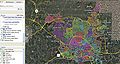
CityWide Map
(Click to enlarge)

- You now have the ability to zoom in to street level and out and click on individual Beats/Districts and see which beats cover which areas.
Wake County Sheriff Unit Numbering
- 100 units are administrative
- 200 units are investigators
- 300 units are SRO's (School Resource Officers)
- 400 units are jail transport
- 500 units are judicial services
- 600 units are A Platoon units...Patrol (regular road deputies)
- 800 units are B Platoon units...Patrol (regular road deputies)
- 900 units are STOP/IMPACT & K-9 Units (STOP are deputies that do traffic enforcement and IMPACT are Drug enforcement patrol units).
The zone map is mainly just for assignment purposes. Road deputies are assigned to a zone or zones at the beginning of their shift. They will usually be assigned calls in their zone or an adjacent zone if needed.
Wake County Sheriff Dept Maps
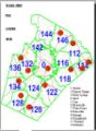
Dept Zone Layout
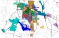
Dept Beat Map


Raleigh/Wake County 10 Codes/Signals
Raleigh Ten Codes

Raleigh (NC) Fire Dept. (WPCI922)
- Sta. #1 - 220 S. Dawson St. (aka State Route 50/US-70/US-401) between W. Hargett St. & W. Martin St. (KII313) (Engine 1/Engine 13/Ladder 4/Fire Invest Unit/Car 401/Car 402)
- Sta. #2 - 263 Pecan Rd. between S. Saunders St. (aka State Route 50/US-70/US-401) & Renfrow Rd. (KII313) (Engine 2/Haz-Mat 1)
- Sta. #3 - 11-13 S. East St. between New Bern Ave. & Morson St. (KII313) (Engine 3)
- Sta. #4 -
- Current Sta. - 121 Northway Ct. @ Horizon Dr. (Engine 4/Ladder 1)
- Former Sta. - 505 Jefferson St. between Glenwood Ave. & Filmore St.
- Sta. #5 - 300 Oberlin Rd. @ 1920-1922 Park Dr. (Engine 5)
- Sta. #6 -
- Current Sta. - 2601 Fairview Rd. @ Oberlin Rd. (Engine 6)
- Former Sta. - 2519 Fairview Rd. between Oberlin Rd. & St. Mary's St.
- Sta. #7 - 2100 Glascock St. @ N. Raleigh Blvd. (Squad 7/Mini-Pumper 2)
- Sta. #8 -
- Current Sta. - 5001 Western Blvd. between Pineland Cir. & Gannett St. (Engine 8/Battalion 3/Air Truck/Haz-Mat 3)
- Former Sta. - 1007 Method Rd. between Western Blvd. & Reavis Rd.
- Sta. #9 - 4465 Six Forks Rd. @ Rowan St. (Engine 9/Battalion 5)
- Sta. #10 - 2711 Sanderford Rd. between Seabrook Rd. & Elkpark Dr. (Engine 10)
- Sta. #11 - 2925 Glenridge Dr. between Highwoods Blvd. & Ward Rd. (Engine 11/Ladder 2)
- Sta. #12 -
- Current Sta. - 4302-4306 Poole Rd. (aka County Route 1007) @ 803-807 Bus Way (WNYY760) (Engine 12/Ladder 8/Battalion 2)
- Former Sta. - 3409 Poole Rd. (aka County Route 1007) between Birch Ridge Dr. & Samuel Rd.
- Sta. #14 - 4220 Lake Boone Trl. between Rexwoods Dr. & Rex Way (WNYY760) (Squad 14/Mini-Pumper 3)
- Sta. #15 - 1815 Spring Forest Rd. across from Sentinel Dr. (WNYY760) (Engine 15)
- Sta. #16 - 5225 Lead Mine Rd. between Belsay Dr. & Yorkgate Dr. (WNYY760) (Engine 16/Rescue 1)
- Sta. #17 - 4601 Pleasant Valley Rd. between Duraleigh Rd. & Grove Church Rd. (WNYY760) (Engine 17/Ladder 3)
- Sta. #18 - 8200 Morgans Way @ Creedmoor Rd. (aka State Route 50) (WNYY760) (Engine 18/Battalion 4)
- Sta. #19 - 4209 Spring Forest Rd. between Sedgewick Dr. & Somerset Springs Dr. (WNYY759) (Engine 19/Battalion 1)
- Sta. #20 - 1721 Trailwood Dr. between Main Campus Dr. & Crump Rd. (WNYY759) (Engine 20/Ladder 7)
- Sta. #21 - 2651 Southall Rd. between Eagle Trace Dr. & Skycrest Dr. (Engine 21/Swift Water Rescue 801)
- Sta. #22 -
- Current Sta. - 9350 Durant Rd. (aka County Route 2006) between Leslieshire Dr. & Hawksmoor Dr. (Engine 22/Ladder 5/Haz-Mat 4)
- Temporary Sta. - 10231 Falls of Neuse Rd. (aka County Route 2000) between Durant Rd. (aka County Route 2006) & Raven Ridge Rd. (aka County Route 2010) (The Crew Quarters sat at the following coordinates: 35.914376/-78.599710 & the Engine Bay sat at the following coordinates: 35.914405/-78.599965)
- Sta. #23 - 8312 Pinecrest Rd. between Seafarer Ct. & O'Neal Rd. (Engine 23/Ladder 9) (Sta. #23 is shared with the Durham Highway V.F.D. Sta. #2)
- Sta. #24 - 10440 Fossil Creek Ct. between Brier Creek Pkwy. & Dead End (Engine 24/Ladder 6) (Sta. #24 sits at the Dead End)
- Sta. #25 - 2740 Wakefield Crossing Dr. between Queensland Rd. & Berks Way (Engine 25/Ladder 5/Haz-Mat)
- Sta. #26 - 3929 Barwell Rd. between Barwell Park Dr. & Tomahawk Trl. (Engine 26/Ladder 8)
- Sta. #27 - 5916 Buffaloe Rd. (aka County Route 2215) between Woodchurch Ct. & Tallyhoe Dr. (Engine 27/Haz-Mat 5)
- Sta. #28 - 3500 Forestville Rd. (aka County Route 2049) between Mitchell Mill Rd. (aka County Route 2224) & Hopper St. (Engine 28/Ladder 9/Mini-Pumper 1/Air 2)
- Sta. #29 - 12117 Leesville Rd. (aka County Route 1839) @ Englehardt Dr. (Engine 29/Haz-Mat 2)
- Capital Hose Co. - 115-117 W. Morgan St. between S. McDowell St. (aka State Route 50/US-70/US-401) & S. Salisbury St. ***(NOW CLOSED)***
Related Links
- Wake County (NC) EMS 800Mhz Viper System Procedures
- Wake County (NC) Fire Brevity Codes
- Wake County (NC) Tone-Out List
- Wake County (NC) Raleigh EMS Medical Priority Codes
- Wake County (NC) Raleigh PD Monitoring Guide
- Wake County NC EMS Station IDs
- Raleigh Durham International Airport (RDU) Wake County (NC)
Return to DB page: Wake County (NC)
Return to Wiki page: North Carolina Counties