Travel Reference (VA) I-495
From The RadioReference Wiki
 Image Attribution and License |
General Info
For the convenience of travelers visiting Virginia, the set of Travel Reference (VA) pages collectively lists the Interstates, US Highways, and national parkways and trails which cross Virginia state borders. The lists include details such as approximate mile marker, county, city, nearest VA STARS antenna site, VSP district, and very brief notes or names of major landmarks. When possible, the county and/or city names are linked to the proper RR Wiki page. For convenience, references are listed below each table and include links when possible.
Other Travel Reference (VA) Pages
I-495
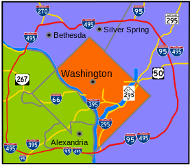
- Interstate 495 is also known as the Capital Beltway. Maryland and Virginia coordinated their exit-numbering.
- Exit numbers start on the Woodrow Wilson Bridge and increase when traveling in the outer/counter-clockwise lanes.
| Mile | County | City | STARS Site | VSP Div |
Notes | Exit Nbr |
| 42.24 | 117 Fairfax 119 Arlington |
7 | Virginia/Maryland state-line on the American Legion Memorial Bridge over the Potomac River | |||
| 42.73 | Fairfax | McLean | 117 Fairfax 119 Arlington |
7 | GW Parkway South | 43 |
| 43.71 | Fairfax | McLean | 117 Fairfax 119 Arlington |
7 | SR 193 / Georgetown Pike Claude Moore Colonial Farm, NPS:CMCF |
44 |
| 45.31 | Fairfax | Tysons Corner | 117 Fairfax 119 Arlington |
7 | SR 267 / Dulles Toll Rd to I-66 East / Dulles Access Road Dulles International Airport (IAD), AirNav:KIAD |
45 |
| 46.23 | Fairfax | Tysons Corner | 117 Fairfax 119 Arlington |
7 | SR 123 / Chain Bridge Rd | 46 |
| 47.16 | Fairfax | Tysons Corner | 117 Fairfax 119 Arlington |
7 | SR 7 / Leesburg Pike | 47 |
| 48.98 | Fairfax | Dunn Loring | 117 Fairfax 119 Arlington |
7 | I-66 | 49 |
| 49.74 | Fairfax | Dunn Loring | 117 Fairfax 119 Arlington |
7 | US 50 / Arlington Blvd to US 29 | 50 |
| 51.08 | Fairfax | Dunn Loring | 117 Fairfax 119 Arlington |
7 | SR 650 / Gallows Rd | 51 |
| 52.43 | Fairfax | Annandale | 117 Fairfax 119 Arlington |
7 | SR 236 / Little River Turnpike | 52 |
| 54.26 | Fairfax | Annandale | 117 Fairfax 119 Arlington |
7 | SR 620 / Braddock Rd | 54 |
| 57.60 | Fairfax | Springfield | 117 Fairfax 119 Arlington |
7 | I-95 South to SR 644 / I-395 North (I-495 Outer Loop coincides with I-95 North) |
I-495 Exit 57 I-95 Exit 170 (interstates overlap) |
| 58.82 | Fairfax | Franconia | 117 Fairfax 119 Arlington |
7 | SR 613 / Van Dorn St (I-495 Outer Loop coincides with I-95 North) |
I-95 Exit 173 (interstates overlap) |
| 60.02 | Fairfax | Rose Hill | 117 Fairfax 119 Arlington |
7 | Eisenhower Av Connector (I-495 Outer Loop coincides with I-95 North) |
I-95 Exit 174 (interstates overlap) |
| 62.43 | Fairfax | Huntington | 117 Fairfax 119 Arlington |
7 | SR 241 / Telegraph Rd (I-495 Outer Loop coincides with I-95 North) |
I-95 Exit 176 (interstates overlap) |
| 63.62 | Alexandria | 117 Fairfax 119 Arlington |
7 | US 1 / GW Parkway South (I-495 Outer Loop coincides with I-95 North) |
I-95 Exit 177 (interstates overlap) | |
| 64.23 | 117 Fairfax 119 Arlington |
7 | Virginia/District of Columbia state-line on the Woodrow Wilson Bridge over the Potomac River (I-495 Outer Loop coincides with I-95 North) |
(interstates overlap) |
References: Wikipedia - I-495 in VA , RR Wiki: VA STARS, STARS Google Map
External Sites
- Virginia.gov: Visit - Offical site for the Commonwealth of Virginia
- Virginia.gov: Virginia Roads, 511Virginia Traffic Info, Truck Routes, DMV Crash Locations Map
- Virginia.gov: Historical and Genealogical Societies in Virginia
- Virginia.gov: State Parks
- Virginia Amber Alerts, Virginia Senior Alerts, Virginia Locality Alert Notification Sign-ups
- USGS: National Map
Return to Wiki pages: Virginia (US)
(No matching DB page)