Actions

Travel Reference (VA) US 221

From The RadioReference Wiki
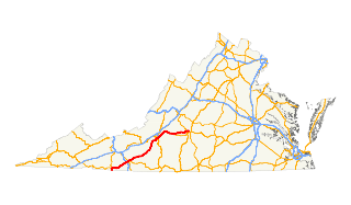
US 221
Image Attribution and License


General Info

For the convenience of travelers visiting Virginia, the set of Travel Reference (VA) pages collectively lists the Interstates, US Highways, and national parkways and trails which cross Virginia state borders. The lists include details such as approximate mile marker, county, city, nearest VA STARS antenna site, VSP district, and very brief notes or names of major landmarks. When possible, the county and/or city names are linked to the proper RR Wiki page. For convenience, references are listed below each table and include links when possible.

Other Travel Reference (VA) Pages

Interstates          US Highways          Parkways and Trails


I-64
I-66
I-74
I-77
I-81
I-85
I-95
I-495
US 1
US 11
US 13
US 15
US 17
     US 19
US 21
US 23
US 29
US 33
     US 48
US 50
US 52
US 58
US 60
     US 121
US 219
US 220
US 221
US 250
     US 258
US 301
US 340
US 421
US 460
     US 501
US 522

USBR 1
USBR 76
Blue Ridge Pkwy
G.W. Memorial Pkwy
Appalachian Trail
Iron Mountain Trail
Overmountain Victory Trail
Potomac Heritage Trail
Washington-Rochambeau
STARS Sites and Nearby Routes List

US 221

Mile County City STARS Site VSP
Div
Notes Exit Nbr
0.00 Grayson 211 Buck Mtn 4 NC State line
3.86 Grayson 211 Buck Mtn 4 US 21 North / Independence Av / US 58 / Main St
Grayson Co. Tourism
6.61 Grayson 211 Buck Mtn 4 SR 274 East / Riverside Dr
15.29 Grayson 211 Buck Mtn 4 SR 94 North / Riverside Dr
18.42 Galax 211 Buck Mtn 4 SR 89 South / Main St
Twin County Regional Healthcare, Jeff Matthews Museum
28.69 Carroll Hillsville 209 Beamer Knob
229 Lambsburg
4 I-77 I-77 Exit 14
28.7 Carroll Hillsville 209 Beamer Knob
229 Lambsburg
4 US 52 / Main St
Carroll County Historical Museum
31.51 Carroll Hillsville 209 Beamer Knob
229 Lambsburg
4 US 58 East / Stuart Dr
32.95 Carroll Hillsville 209 Beamer Knob
229 Lambsburg
4 SR 100 North / Sylvatus Smith Hwy / SR 669 South / Hardscuffle Rd
59.09 Floyd Floyd 219 Bull Mtn 6 SR 8 / Locust St
Floyd County Historical Society Museum
79.9 Roanoke 218 Fort Lewis Mtn 6 Blue Ridge Parkway
93.0 Roanoke Cave Spring 218 Fort Lewis Mtn
233 Potts Mtn
6 SR 419 / Electric Rd
96.03 Roanoke Roanoke 218 Fort Lewis Mtn
233 Potts Mtn
6 Brandon Av
VA Western Community College, Carilion Roanoke Community Hospital
97.15 Roanoke Roanoke 218 Fort Lewis Mtn
233 Potts Mtn
6 Franklin Rd
97.45 Roanoke Roanoke 218 Fort Lewis Mtn
233 Potts Mtn
6 SR 24 East / Elm Av / SR 116 South / Jefferson St
97.73 Roanoke Roanoke 218 Fort Lewis Mtn
233 Potts Mtn
6 US 11 South / Campbell Av
98.03 Roanoke Roanoke 218 Fort Lewis Mtn
233 Potts Mtn
6 I-581 South / US 220 North
98.53 Roanoke Roanoke 218 Fort Lewis Mtn
233 Potts Mtn
6 US 11 North / Williamson Rd / US 460 / US 11 Alt. South / US 220 Alt. South / SR 116 North / Orange AV
99.02 Roanoke Roanoke 218 Fort Lewis Mtn
233 Potts Mtn
6 SR 115 North / Hollins Rd
103.34 Roanoke Bonsack 218 Fort Lewis Mtn
233 Potts Mtn
6 US 220 Alt. North / Cloverdale Rd
106.23 Botetourt Blue Ridge 218 Fort Lewis Mtn
233 Potts Mtn
6 Blue Ridge Parkway
124.46 Bedford Bedford 225 Apple Orchard 6 US 460
National D-Day Memorial
125.54 Bedford Bedford 225 Apple Orchard 6 SR 122 Bus. South / Crewshaw St
125.73 Bedford Bedford 225 Apple Orchard 6 US 460 Bus. East / SR 43 South / Main St
126.00 Bedford Bedford 225 Apple Orchard 6 SR 43 North / Peaks St
127.18 Bedford Bedford 225 Apple Orchard 6 SR 122 / Independence Blvd / Longwood Av
144.93 Lynchburg 201 Long Mtn 6 US 501 / Lynchburg Expressway
148.11 Lynchburg 201 Long Mtn 6 SR 163 / Memorial Av
148.35 Lynchburg 201 Long Mtn 6 US 460 Bus. West / Fort Av
149.02 Lynchburg 201 Long Mtn 6 US 501 Bus. North / Campbell Av
Centra Lynchburg General Hospital, Ann Spencer House and Garden Museum
149.61 Lynchburg 201 Long Mtn 6 US 29 Bus. / Lynchburg Expressway / US 460 Bus. East / US 501 Bus. South / Kemper St

References: Wikipedia - US 221 in VA , RR Wiki: VA STARS, STARS Google Map

External Sites


Return to Wiki pages: Virginia (US)
(No matching DB page)