STARCOM21 Statewide Illinois
From The RadioReference Wiki
Return to STARCOM21 Database page
Radio/Unit IDs
Illinois Counties Starcom21.com - Links directly to the RadioReference.com database page
Wiki Home → Collaboration Gateway → United States → Illinois, Iowa → STARCOM21 Statewide Illinois TRS
Welcome to the STARCOM21 Statewide Illinois collaboration article, a Multi-State Public Trunked Radio System located in Illinois, Iowa, United States.
This is where you, the user, may index any articles you develop for scanning related topics for this Trunked Radio System.
- Some talkgroups on this system may be using P25 Phase II TDMA modulation, which can only be monitored using a P25 Phase II capable scanner or receiver.
- Click HERE for a list of scanners capable of monitoring those talkgroups.
Contents
Information
- STAte Radio (Voice) COMmunications for the 21st Century.
- Subscriber information PDF
Related Wiki Pages and Links
- ISP Conventional Radio Database page WIKI
- SC21 FAQ FAQ
- Unidentified Talkgroup Information
Site/Tower NACs (No longer being updated)
STARCOM21 is the Statewide Motorola Project 25 TRS in Illinois for public safety radio communications. The purpose of this page is to provide supplemental information to the Radioreference.com Starcom21 page.
Department of Innovation and Technology WEB/Info
- The network is owned and operated by Motorola Solutions and currently serves more than 45,000 subscribers from various State, local and federal government and non-governmental entities. It is a statewide, 700/800 MHz, Project 25-compliant, digital, trunked voice radio network that is open to all public safety and public service agencies in the State of Illinois. Non-State entities must work with Motorola Solutions directly to apply for network access. State agencies and non-State entities alike must complete a SC21 Oversight Committee System Access application to commence ordering equipment. SC21 services are coordinated and administered for State entities (State agencies, boards, commissions, etc., not including the General Assembly) through an agreement between DoIT and the Illinois State Police (ISP) Multi-Agency Communications Services Section (MACSS group).
SC21 also figures prominently in the Statewide Communications Interoperability Plan (SCIP), which establishes a single statewide platform for all public safety agencies to share emergency information. Managed by the Illinois Emergency Management Agency (IEMA), SCIP was developed by a consortium of federal, state, and local public safety practitioners working through the Illinois Terrorism Task Force's (ITTF’s) Communications Committee and the Statewide Interoperability Executive Committee. For more information on the SCIP please go to Statewide Communication Interoperability
WAVE Service
The STARCOM21 network supports a cellular broadband service through the Motorola Solutions Inc. WAVE Application. This provides the agency with the ability to connect their mobile smartphone to a STARCOM21 Astro25 Talkgroup or create broadband only talkgroups, these will not connect in any way to SC21. See WAVE PTX
Major Users of STARCOM21
- Illinois State Police Database page WIKI
- Conservation Police / Secretary of State Police
- Department of Natural Resources Police
- Illinois Department of Transportation
- Illinois Department of Corrections
- IEMA / ITTF / ILEAS
Every hospital in the state, in additional to nearly every municipality and/or fire district in the state should have a SC21 radio (somewhere)
Radio IDs (RIDs) / User IDs (UIDs)
Feel free to add any RIDs to the lists below, using the current format.
- 00001 - 19999 Motorola / Testing / ISTHA - Page 1
- 20000 - 22999 St Clair County - Page 2
- 23000 - 25999 St Clair County - Page 3
- 26000 - 27999 St Clair County - Page 4
- 28000 - 32999 Will/Lee/McHenry - Page 5
- 33000 - 37999 McH/DuP/Boone - Page 6
- 38000 - 79000 Page 7
- 80000 - 89999 Page 8
- 90000 - 99000 Page 9
- 100xxx - 139999 Cook County/Chicago Metro Area - Page 10
- 140xxx - 199xxx Cook/Kankakee/McHenry/Will Counties - Page 11
- 200xxx - 299xxx - Page 12
- 200xxx - 299xxx Lake/Winnebago - Page 13
- 300xxx - 349xxx Elgin/Kane - Page 14
- 350xxx - 361xxx IDOC/IDJJ, IDOT - Page 15
- 362xxx - 390xxx IDOT, others - Page 16
- 400xxx - 409xxx IEMA, etc - Page 17
- 410xxx - 410xxx ITTF Dispatch Centers/IDPH - Page 18
- 411xxx - 412xxx ITTF Dispatch Centers/IDPH - Page 19
- 413xxx - 416xxx McLean Co/IEMA CommCtr/ISU - Page 20
- 417xxx - 427xxx Page 21
- 428xxx - 433xxx Page 22
- 434xxx - 497xxx State/Counties? - Page 23
- 500xxx - 650xxx Sangamon/Ameren/IDOC - Page 24
- 651xxx - 699xxx Ameren/IEMA/ICC/SOS? - Page 25
- 700xxx - 759xxx Madison/Zone 3?/BD-CL/??? - Page 26
- 767xxx - 840xxx Madison/Monroe Counties - Page 27
- 100xxxx - 109xxxx ISP North - Page 28
- 110xxxx - 1109999 ISP North - Page 29
- 111xxxx - 199xxxx Page 30
- 200xxxx - 299xxxx ISP Z2 Center - Page 31
- 300xxxx - 399xxxx ISP Z3 South - Page 32
- 400xxxx - 587xxxx McLean/Cook Counties - Page 33
- Future Use - Page 34
- Future Use - Page 35
- Future Use - Page 36
- Future Use - Page 37
- 600xxxx - 689xxxx Pace? - Page 38
- 700xxxx - 70063xx Pace Bus - Page 39
- 70064xx - 8919xxx Pace Bus, others - Page 40
- 1000xxxx - 1005xxxx Harper College, Lifenet 3-1, others - Page 41
- Champaign County MDICE
- St Louis City P25 RIDs (UIDs) (For Reference) MOSWIN - Statewide Missouri (and St Louis City)
- SLATER - MO Counties surrounding St Louis City / Metro
Unidentified/Unconfirmed Talk Group IDs (TGIDS)
Sites
Future Sites
- New 8/25 - "SY" Trunked at 2995 NORTH 2500E ROAD, BEAVERVILLE - 771.71875, 772.44375, 773.41875, 774.46875 125W Repeaters with 300-35W mobiles (P25) Application 0011704100
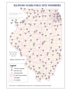
Site/Tower Google Map
(NOT UPDATED) This may prove I have too much time on my hands, but I have taken all of the information from the CARMA profile and plotted all the transmit sites for StarCom using the "my maps" feature of Google Maps. Anyone wanting to check it out can go here: Link
A few things about the map:
- After plugging in the coordinates for each site on the map I tried to locate the exact tower or structure used by a combination of satellite view, street view, and in some cases switching to Microsoft's Bing Maps for their Birds Eye view. If it still wasn't exactly clear I made a guess usually just putting the mark where the lat/lon coordinates landed me.
- Pushpins are used for single site locations, blue for the north zone, green for central, and purple for south.
- The "balloon" type pins are used on all simulcast sites, with different colors for each site.
- At this time I included the county owned sites that use the same technology as StarCom including McHenry County (all of these being co-located with StarCom sites), Champaign's MDICE, and the St. Clair County system. My only regret doing this is that with all these sites included Google shows two separate pages for the sites, so not all of them are visible at one time on the map. I'm debating whether to take these sites out and make the map strictly StarCom so all the sites show up at once.
Google allows anyone with a Google account to make changes to the map, however I have it set up to only allow those that I invite to make the changes. If anyone is interested in helping to maintain the map or make corrections or additions to it, send me your e-mail address and I will add your name to the list. If you notice any errors either in locations of towers or the control channels listed and don't have a Google account or don't want to mess with the map, e-mail me and I will be glad to make the corrections.
Comments, praise, and even criticisms are welcome. -Mike McGowan - K9JPM
New StarCom21 tower map (Click here) - The above map has become outdated; I've attempted to reach the map owner to offer help to update the map, have not gotten a response. I have created a map that display updated and current tower locations for 8 digital systems within the state. Last update to the map for each system is in the description of the map. If you have any questions, comments, concerns please feel free to contact me. Enjoy! - Isaiah (Mex)
For a printable map of tower sites, click the image below:

Former Sites
- Many other sites have also changed and/or been moved
| Site | Name | County | Freqs | ||||||
|---|---|---|---|---|---|---|---|---|---|
| 3 (3) 905 (389) | Belleville [OFF AIR - was 3-005] | St. Clair | 851.33750 | 851.86250c | 852.38750a | 852.91250a | |||
| 3 (3) 925 (39D) | Edwardsville/SIUE [OFF AIR - was 3-025] | Madison | 851.25000 | 851.83750 | 852.11250c | 852.77500a | 853.66250a | 853.98750 | 854.01250 |
| 858.33750 | 860.33750 | ||||||||
| 3 (3) 953 (3B9) | Caseyville [OFF AIR - was 3-053] | St. Clair | 774.05625 | 774.28125c | 774.59375a | 774.81875a | |||
| 3 (3) 955 (3BB) | Godfrey/Alton [OFF AIR - was 3-055] | Madison | 851.35000a | 851.87500c | 852.40000a | 852.66250 | 853.08750 | 858.21250 | |
| 3 (3) 999 (3E7) | Mascoutah [OFF AIR - was 3-001] | St. Clair | 774.78125 | 775.34375c | 775.55625a | 775.80625a | 855.16250 | 859.33750 | |
| 3 (3) 999 (3E7) | East St. Louis [OFF AIR 11/12 - was 3-023] | St. Clair | 851.83750 | 852.36250c | 852.88750a | 853.98750a | 858.33750 |
- 5 (5) 020 (14) Conesville (MUSCOM) Muscatine, IA 854.0375 854.3375 855.4875 856.5375c; unknown NAC
- 5 (5) 021 (15) West Liberty (MUSCOM) Muscatine, IA 854.2875 854.6875 856.1625c 857.4875c 141 NAC WQWY303
- 5 (5) 022 (16) Muscatine (MUSCOM) Muscatine, IA 854.1875 854.5375 854.7125 857.1375c 142 NAC
- 5 (5) 023 (17) Wilton (MUSCOM) Muscatine, IA 854.4125c 856.1875 857.5375 858.5375c
- Motorola - STARCOM21 web site (OLD)
- https://www2.illinois.gov/sites/doit/services/catalog/Documents/STARCOM21_Subscriber_List.pdf <- Subscriber List (OLD)
Others Users
- Ameren Utility Company (AmerenIP, AmerenCIPS, AmerenUE)
- Ameren uses 800 MHz voice channels on 700 MHz control channel sites.
- Statewide Ameren Mobile License WNQJ842
Illinois State Police
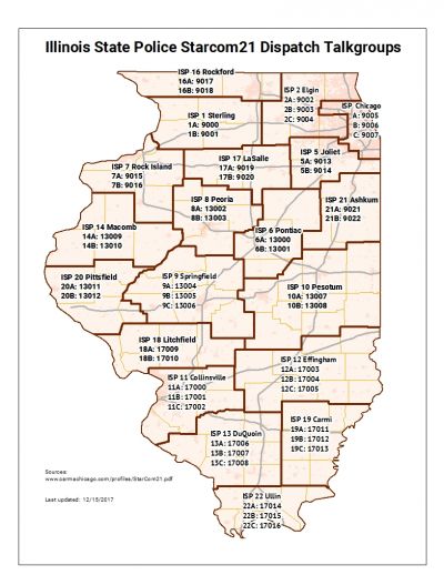
The Illinois State Police (ISP) is using the Starcom21 TRS as its primary means of communication. VHF may be used infrequently as an alternate channel in some districts. 155.4750 ISPERN is still in use.
- ISP District Chicago as of 9/18/07
- ISP District 1 (Sterling) as of 9/6/2007
- ISP District 2 (Elgin) as of ?/?/2007
- ISP District 5 (Joliet) as of late August 2007
- ISP District 6 (Pontiac) as of 8/14/2007
- ISP District 7 (Rock Island) as of 8/23/2007
- ISP District 8 (Peoria) as of 8/16/2007
- ISP District 9 (Springfield) as of 8/2/2007
- ISP District 10 (Pesotum) as of 8/9/2007
- ISP District 11 (Collinsville) as of 7/24/2007
- ISP District 12 (Effingham) as of 7/27/2007
- ISP District 13 (DuQuoin) as of ?April 2007
- ISP District 14 (Macomb) as of 8/21/2007
- ISP District 15 (Chicago Tollways-Oakbrook) as of ?9/2007
- ISP District 16 (Rockford) 9/11/2007
- ISP District 17 (La Salle) as of August 28, 2007
- ISP District 18 (Litchfield) as of 7/31/2007
- ISP District 19 (Carmi) as of ?April 2007
- ISP District 20 (Pittsfield) as of 8/?/2007
- ISP District 21 (Ashkum) as of 9/4/2007
- ISP District 22 (Ullin) as of ?April 2007
Related Links / Pages
- MABAS SC21 Powerpoint (stored as a PDF file)
- ITTF STARCOM21 PDF
- News and Info on St. Clair County's Project In Conjunction With STARCOM21
Return to Wiki page: Trunked Radio Systems (IN), Trunked Radio Systems (IA)


